Property Record
6010 Utsa Blvd, San Antonio, TX 78249


Save to a Folder
{{folder.Name}}
{{folder.ListingIds.length}} Properties
{{folder.ListingIds.length}} Property
Create a New Folder
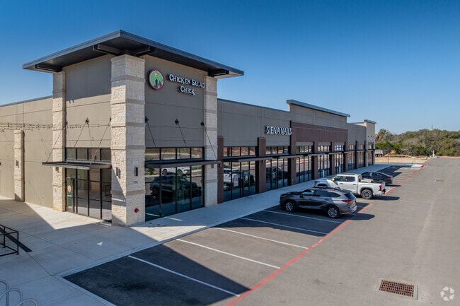
Property Detail
6010 Utsa Blvd
San Antonio-New Braunfels, TX
NCB 14890 (ROADRUNNER CREEK RETAIL), BLOCK 15 LOT 4 EXC E IRR 126.12 FT (4.023 AC) 2025- REMAINS PER SPLIT PER DEED 20240235759 ( .115 ACRES CONVEYED)
14890-015-0040
BEXAR
Regionalshoppingcenterormallwithanchorstore
Texas
AE The base floodplain where base flood elevations are provided. AE Zones are now used on new format FIRMs instead of A1-A30 Zones.
4
2025
4.02 AC
2025
Northwest
181820
San Antonio
21,580 SF
NEARBY LISTINGS FOR SALE OR LEASE
DEMOGRAPHICS near 6010 Utsa Blvd
1 mile
3 mile
5 mile
2025 Total Population
12,175
90,826
238,004
2030 Population
12,985
95,893
250,297
Pop Growth 2025-2030
+ 6.65%
+ 5.58%
+ 5.17%
Average Age
30
36
37
2025 Total Households
4,475
38,004
100,562
HH Growth 2025-2030
+ 7.49%
+ 5.98%
+ 5.48%
Median Household Inc
$67,851
$74,671
$75,946
Avg Household Size
2.10
2.30
2.30
2025 Avg HH Vehicles
2.00
2.00
2.00
Median Home Value
$337,417
$330,833
$350,134
Median Year Built
2008
2001
1996
Nearby Places
Map Layers
Map Styles
 Street
 Aerial
Layers
 Traffic
 Biking
Places
Listings with unknown addresses are not visible on the map
- Restaurants
- Banks
- Shops
- Fitness
- Groceries
PUBLIC TRANSPORTATION
AIRPORT
San Antonio International
Drive
Walk
Distance
San Antonio International
16 min
11.8 mi
Freight Ports
Calhoun Port
Drive
Walk
Distance
Calhoun Port
197 min
165.3 mi
Nearby Properties
Address
Land Use
TOTAL SIZE
Lot Size
Zoning
Address
Land Use
TOTAL SIZE
Lot Size
Zoning
437,060 SF
91.31 AC
Address
Land Use
TOTAL SIZE
Lot Size
Zoning
405,133 SF
16.41 AC
Address
Land Use
TOTAL SIZE
Lot Size
Zoning
538,895 SF
54.58 AC
Address
Land Use
TOTAL SIZE
Lot Size
Zoning
335,841 SF
33.70 AC
Address
Land Use
TOTAL SIZE
Lot Size
Zoning
538,895 SF
60.25 AC
Address
Land Use
TOTAL SIZE
Lot Size
Zoning
509,312 SF
43.63 AC
Address
Land Use
TOTAL SIZE
Lot Size
Zoning
391,367 SF
11.36 AC
Address
Land Use
TOTAL SIZE
Lot Size
Zoning
940,089 SF
63.74 AC
Address
Land Use
TOTAL SIZE
Lot Size
Zoning
499,480 SF
19.57 AC
Address
Land Use
TOTAL SIZE
Lot Size
Zoning
21,348 SF
14.50 AC
Address
Land Use
TOTAL SIZE
Lot Size
Zoning
462,227 SF
31.21 AC
Address
Land Use
TOTAL SIZE
Lot Size
Zoning
13,128 SF
5.23 AC
Address
Land Use
TOTAL SIZE
Lot Size
Zoning
300,264 SF
27.81 AC
Address
Land Use
TOTAL SIZE
Lot Size
Zoning
21,852 SF
5.25 AC
Address
Land Use
TOTAL SIZE
Lot Size
Zoning
331,715 SF
9.04 AC
Address
Land Use
TOTAL SIZE
Lot Size
Zoning
10,622 SF
8.01 AC
Address
Land Use
TOTAL SIZE
Lot Size
Zoning
389,048 SF
16.25 AC
Address
Land Use
TOTAL SIZE
Lot Size
Zoning
329,050 SF
17.10 AC
Address
Land Use
TOTAL SIZE
Lot Size
Zoning
320,406 SF
12.11 AC
Address
Land Use
TOTAL SIZE
Lot Size
Zoning
515,812 SF
200.45 AC
Address
Land Use
TOTAL SIZE
Lot Size
Zoning
305,497 SF
9.99 AC
Address
Land Use
TOTAL SIZE
Lot Size
Zoning
395,039 SF
31 AC
Address
Land Use
TOTAL SIZE
Lot Size
Zoning
6,809 SF
9.04 AC
Address
Land Use
TOTAL SIZE
Lot Size
Zoning
238,999 SF
8.43 AC
Address
Land Use
TOTAL SIZE
Lot Size
Zoning
309,429 SF
5.17 AC
Address
Land Use
TOTAL SIZE
Lot Size
Zoning
152,266 SF
18.72 AC
Address
Land Use
TOTAL SIZE
Lot Size
Zoning
183,249 SF
21.94 AC
Address
Land Use
TOTAL SIZE
Lot Size
Zoning
244,260 SF
5.82 AC
Address
Land Use
TOTAL SIZE
Lot Size
Zoning
520,686 SF
53.63 AC
Address
Land Use
TOTAL SIZE
Lot Size
Zoning
349,074 SF
27.84 AC
The World's #1 Commercial Real Estate Marketplace
Connect with us
© 2026 CoStar Group
The information above has been obtained from sources believed reliable. While we do not doubt its accuracy we have not verified it and make no guarantee, warranty or representation about it. It is your responsibility to independently confirm its accuracy and completeness. Any projections, opinions, assumptions, or estimates used are for example only and do not represent the current or future performance of the property. The value of this transaction to you depends on tax and other factors which should be evaluated by your tax, financial, and legal advisors. You and your advisors should conduct a careful, independent investigation of the property to determine to your satisfaction the suitability of the property for your needs.