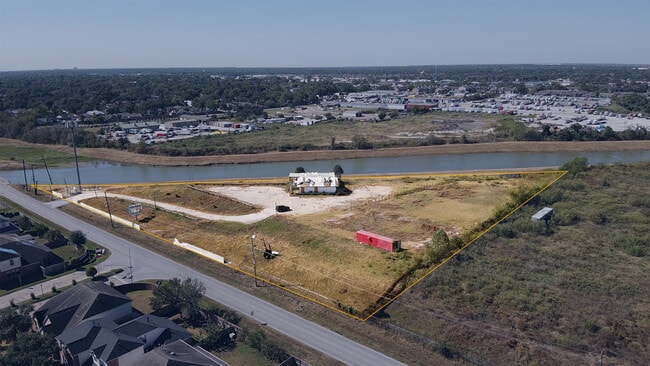
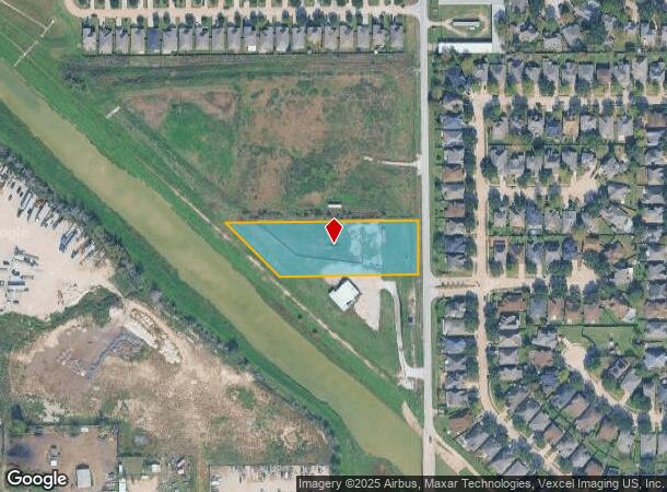
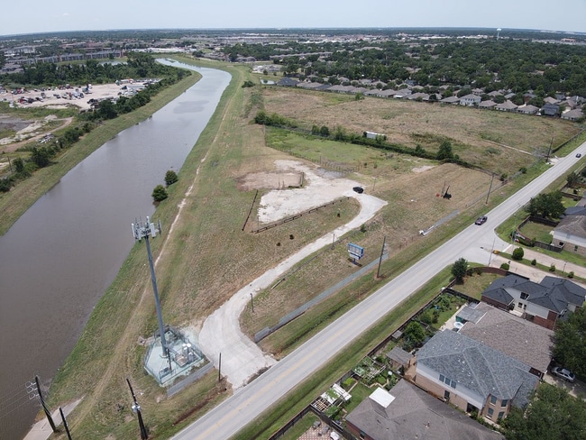
Property Record
0 Addicks Satsuma Rd, Houston, TX 77084
NEARBY LISTINGS FOR SALE OR LEASE
Property Detail
0 Addicks Satsuma Rd
Houston-The Woodlands-Sugar Land, TX
Seven Star Plus
1409880010001
RES A BLK 1 SEVEN STAR PLUS
Commercialnec
Harris
AE
Texas
48201C0610M
1.98 AC
2024
FM 1960/Hwy 249
2025
Houston
541604
DEMOGRAPHICS near 0 Addicks Satsuma Rd
1 Mile
3 Mile
5 Mile
2024 Total Population
19,038
107,017
254,708
2029 Population
19,278
108,110
257,546
Pop Growth 2024-2029
+ 1.26%
+ 1.02%
+ 1.11%
Average Age
35
37
36
2024 Total Households
6,592
35,590
85,254
HH Growth 2024-2029
+ 1.38%
+ 1.00%
+ 1.07%
Median Household Inc
$60,446
$74,956
$78,894
Avg Household Size
2.80
2.90
2.90
2024 Avg HH Vehicles
2.00
2.00
2.00
Median Home Value
$195,650
$216,642
$225,155
Median Year Built
1986
1989
1995
Nearby Places
Map Layers
Map Styles
 Street
 Aerial
- Restaurants
- Banks
- Shops
- Fitness
- Groceries
PUBLIC TRANSPORTATION
AIRPORT
George Bush Intcntl/Houston
DRIVE
WALK
Distance
George Bush Intcntl/Houston
37 min
26.2 mi
William P Hobby
DRIVE
WALK
Distance
William P Hobby
55 min
34.8 mi
Freight Ports
Port of Houston
DRIVE
WALK
Distance
Port of Houston
47 min
30.4 mi
SALE & LEASE HISTORY
LISTING DATE
SALE/LEASE

Oct 21, 2024
For Sale
Jul 24, 2025
For Lease
Nearby Properties
Address
Land Use
TOTAL SIZE
Lot Size
Zoning
Address
Land Use
TOTAL SIZE
Lot Size
Zoning
380,959 SF
21.43 AC
Address
Land Use
TOTAL SIZE
Lot Size
Zoning
386,642 SF
14.45 AC
Address
Land Use
TOTAL SIZE
Lot Size
Zoning
120.78 AC
Address
Land Use
TOTAL SIZE
Lot Size
Zoning
358,713 SF
19.91 AC
Address
Land Use
TOTAL SIZE
Lot Size
Zoning
320,084 SF
8.01 AC
Address
Land Use
TOTAL SIZE
Lot Size
Zoning
408,144 SF
26.13 AC
Address
Land Use
TOTAL SIZE
Lot Size
Zoning
392,185 SF
30.73 AC
Address
Land Use
TOTAL SIZE
Lot Size
Zoning
491,051 SF
50 AC
Address
Land Use
TOTAL SIZE
Lot Size
Zoning
388,223 SF
14.99 AC
Address
Land Use
TOTAL SIZE
Lot Size
Zoning
363,896 SF
21.69 AC
Address
Land Use
TOTAL SIZE
Lot Size
Zoning
412,250 SF
45.79 AC
Address
Land Use
TOTAL SIZE
Lot Size
Zoning
112,440 SF
8.02 AC
Address
Land Use
TOTAL SIZE
Lot Size
Zoning
301,102 SF
12.58 AC
Address
Land Use
TOTAL SIZE
Lot Size
Zoning
327,674 SF
15.32 AC
Address
Land Use
TOTAL SIZE
Lot Size
Zoning
493,233 SF
25.82 AC
Address
Land Use
TOTAL SIZE
Lot Size
Zoning
232,717 SF
10.21 AC
Address
Land Use
TOTAL SIZE
Lot Size
Zoning
292,466 SF
12.18 AC
Address
Land Use
TOTAL SIZE
Lot Size
Zoning
312,939 SF
22.80 AC
Address
Land Use
TOTAL SIZE
Lot Size
Zoning
351,468 SF
16.05 AC
Address
Land Use
TOTAL SIZE
Lot Size
Zoning
300,292 SF
15.65 AC
Address
Land Use
TOTAL SIZE
Lot Size
Zoning
250,178 SF
Address
Land Use
TOTAL SIZE
Lot Size
Zoning
488,411 SF
32.43 AC
Address
Land Use
TOTAL SIZE
Lot Size
Zoning
198,510 SF
17.13 AC
Address
Land Use
TOTAL SIZE
Lot Size
Zoning
150,570 SF
18.16 AC
Address
Land Use
TOTAL SIZE
Lot Size
Zoning
516,943 SF
61.56 AC
Address
Land Use
TOTAL SIZE
Lot Size
Zoning
116,997 SF
10.82 AC
Address
Land Use
TOTAL SIZE
Lot Size
Zoning
257,816 SF
10.43 AC
Address
Land Use
TOTAL SIZE
Lot Size
Zoning
215,153 SF
16.34 AC
Address
Land Use
TOTAL SIZE
Lot Size
Zoning
187,007 SF
9.76 AC
Address
Land Use
TOTAL SIZE
Lot Size
Zoning
125,907 SF
10.54 AC
The World's #1 Commercial Real Estate Marketplace
Connect with us
© 2025 CoStar Group
The information above has been obtained from sources believed reliable. While we do not doubt its accuracy we have not verified it and make no guarantee, warranty or representation about it. It is your responsibility to independently confirm its accuracy and completeness. Any projections, opinions, assumptions, or estimates used are for example only and do not represent the current or future performance of the property. The value of this transaction to you depends on tax and other factors which should be evaluated by your tax, financial, and legal advisors. You and your advisors should conduct a careful, independent investigation of the property to determine to your satisfaction the suitability of the property for your needs.