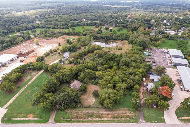
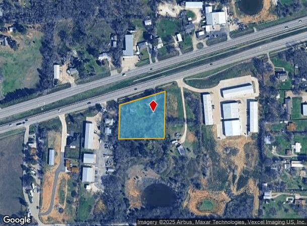
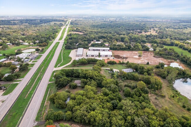
Property Record
6012 E Highway 67, Alvarado, TX 76009
NEARBY LISTINGS FOR SALE OR LEASE
Property Detail
6012 E Highway 67
126-0047-00180
Wm Balch
Farms
ABST 47 TR 22,23 WM BALCH
X
Johnson
48251C0200J
Texas
2024
1.85 AC
2025
Johnson County
130415
Dallas/Ft Worth
1,406 SF
Dallas-Fort Worth-Arlington, TX
DEMOGRAPHICS near 6012 E Highway 67
1 Mile
3 Mile
5 Mile
2024 Total Population
870
10,135
26,608
2029 Population
984
12,047
31,481
Pop Growth 2024-2029
+ 13.10%
+ 18.87%
+ 18.31%
Average Age
43
38
38
2024 Total Households
320
3,400
8,929
HH Growth 2024-2029
+ 13.75%
+ 19.29%
+ 18.78%
Median Household Inc
$66,562
$77,597
$72,795
Avg Household Size
2.70
2.80
2.90
2024 Avg HH Vehicles
2.00
2.00
2.00
Median Home Value
$248,134
$191,403
$191,415
Median Year Built
1991
1992
1990
Nearby Places
Map Layers
Map Styles
 Street
 Aerial
- Restaurants
- Banks
- Shops
- Fitness
- Groceries
PUBLIC TRANSPORTATION
COMMUTER RAIL
Cleburne Amtrak Station (Texas Eagle - Amtrak)
DRIVE
WALK
Distance
Cleburne Amtrak Station (Texas Eagle - Amtrak)
15 min
9.8 mi
Freight Ports
Port of Shreveport
DRIVE
WALK
Distance
Port of Shreveport
248 min
230.7 mi
SALE & LEASE HISTORY
LISTING DATE
SALE/LEASE

Sep 26, 2024
For Sale
Nearby Properties
Address
Land Use
TOTAL SIZE
Lot Size
Zoning
Address
Land Use
TOTAL SIZE
Lot Size
Zoning
157,850 SF
85.56 AC
Address
Land Use
TOTAL SIZE
Lot Size
Zoning
71.29 AC
Address
Land Use
TOTAL SIZE
Lot Size
Zoning
209,318 SF
69.85 AC
Address
Land Use
TOTAL SIZE
Lot Size
Zoning
9.84 AC
Address
Land Use
TOTAL SIZE
Lot Size
Zoning
54,000 SF
13.76 AC
Address
Land Use
TOTAL SIZE
Lot Size
Zoning
106,926 SF
16.28 AC
Address
Land Use
TOTAL SIZE
Lot Size
Zoning
63,911 SF
15 AC
Address
Land Use
TOTAL SIZE
Lot Size
Zoning
45,750 SF
10.49 AC
Address
Land Use
TOTAL SIZE
Lot Size
Zoning
548.67 AC
Address
Land Use
TOTAL SIZE
Lot Size
Zoning
33,000 SF
10.05 AC
Address
Land Use
TOTAL SIZE
Lot Size
Zoning
31,005 SF
9.19 AC
Address
Land Use
TOTAL SIZE
Lot Size
Zoning
17,000 SF
12.49 AC
Address
Land Use
TOTAL SIZE
Lot Size
Zoning
55,300 SF
8.72 AC
Address
Land Use
TOTAL SIZE
Lot Size
Zoning
650 SF
212 AC
Address
Land Use
TOTAL SIZE
Lot Size
Zoning
48,263 SF
10 AC
Address
Land Use
TOTAL SIZE
Lot Size
Zoning
10,510 SF
12 AC
Address
Land Use
TOTAL SIZE
Lot Size
Zoning
18.12 AC
Address
Land Use
TOTAL SIZE
Lot Size
Zoning
236.05 AC
Address
Land Use
TOTAL SIZE
Lot Size
Zoning
29,840 SF
7 AC
Address
Land Use
TOTAL SIZE
Lot Size
Zoning
41,772 SF
1.74 AC
Address
Land Use
TOTAL SIZE
Lot Size
Zoning
24,695 SF
17.88 AC
Address
Land Use
TOTAL SIZE
Lot Size
Zoning
198.97 AC
Address
Land Use
TOTAL SIZE
Lot Size
Zoning
38,919 SF
1.85 AC
Address
Land Use
TOTAL SIZE
Lot Size
Zoning
12,462 SF
1.73 AC
Address
Land Use
TOTAL SIZE
Lot Size
Zoning
4,933 SF
6.45 AC
Address
Land Use
TOTAL SIZE
Lot Size
Zoning
55.03 AC
Address
Land Use
TOTAL SIZE
Lot Size
Zoning
59.96 AC
Address
Land Use
TOTAL SIZE
Lot Size
Zoning
29,108 SF
4.48 AC
Address
Land Use
TOTAL SIZE
Lot Size
Zoning
24,726 SF
5 AC
Address
Land Use
TOTAL SIZE
Lot Size
Zoning
13,968 SF
17.34 AC
The World's #1 Commercial Real Estate Marketplace
Connect with us
© 2025 CoStar Group
The information above has been obtained from sources believed reliable. While we do not doubt its accuracy we have not verified it and make no guarantee, warranty or representation about it. It is your responsibility to independently confirm its accuracy and completeness. Any projections, opinions, assumptions, or estimates used are for example only and do not represent the current or future performance of the property. The value of this transaction to you depends on tax and other factors which should be evaluated by your tax, financial, and legal advisors. You and your advisors should conduct a careful, independent investigation of the property to determine to your satisfaction the suitability of the property for your needs.