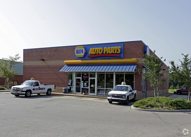
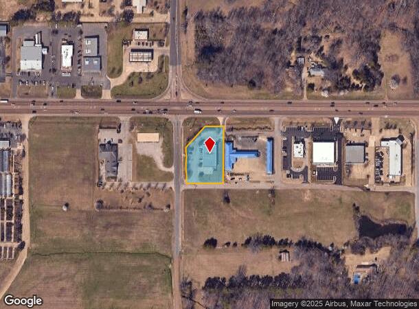
Property Record
6015 Goodman Rd, Olive Branch, MS 38654

NEARBY LISTINGS FOR SALE OR LEASE
Property Detail
6015 Goodman Rd
Memphis, TN-MS-AR
Oaks Commercial S/D Phase 1
1069311500000100
DAVIDSON OAKS COMMERCIAL S/D PHASE 1 LOT 1
Realpropertynec
DeSoto
X
Mississippi
47157C0585F
1
2025
0.94 AC
2025
Olive Branch
070724
Memphis
6,195 SF
DEMOGRAPHICS near 6015 Goodman Rd
1 Mile
3 Mile
5 Mile
2024 Total Population
2,953
21,141
86,957
2029 Population
3,245
23,233
92,796
Pop Growth 2024-2029
+ 9.89%
+ 9.90%
+ 6.71%
Average Age
41
42
39
2024 Total Households
1,034
7,738
31,171
HH Growth 2024-2029
+ 9.96%
+ 9.87%
+ 6.76%
Median Household Inc
$80,295
$87,678
$79,826
Avg Household Size
2.80
2.70
2.80
2024 Avg HH Vehicles
2.00
2.00
2.00
Median Home Value
$275,270
$272,294
$236,255
Median Year Built
2000
2001
1997
Nearby Places
Map Layers
Map Styles
 Street
 Aerial
- Restaurants
- Banks
- Shops
- Fitness
- Groceries
PUBLIC TRANSPORTATION
AIRPORT
Memphis International
DRIVE
WALK
Distance
Memphis International
21 min
12.6 mi
Nearby Properties
Address
Land Use
TOTAL SIZE
Lot Size
Zoning
Address
Land Use
TOTAL SIZE
Lot Size
Zoning
921,576 SF
25.20 AC
CA
Address
Land Use
TOTAL SIZE
Lot Size
Zoning
434,122 SF
23.97 AC
R-6
Address
Land Use
TOTAL SIZE
Lot Size
Zoning
158,366 SF
24.31 AC
R-6
Address
Land Use
TOTAL SIZE
Lot Size
Zoning
326,743 SF
22.91 AC
R-8
Address
Land Use
TOTAL SIZE
Lot Size
Zoning
345,770 SF
18.13 AC
EMP
Address
Land Use
TOTAL SIZE
Lot Size
Zoning
864,054 SF
72.19 AC
M-1
Address
Land Use
TOTAL SIZE
Lot Size
Zoning
3,437 SF
169.11 AC
CA
Address
Land Use
TOTAL SIZE
Lot Size
Zoning
364,578 SF
19.76 AC
IH
Address
Land Use
TOTAL SIZE
Lot Size
Zoning
366,046 SF
22.37 AC
CA
Address
Land Use
TOTAL SIZE
Lot Size
Zoning
307,100 SF
18.95 AC
CA
Address
Land Use
TOTAL SIZE
Lot Size
Zoning
309,885 SF
17.49 AC
R-8
Address
Land Use
TOTAL SIZE
Lot Size
Zoning
860,464 SF
54.55 AC
M-1
Address
Land Use
TOTAL SIZE
Lot Size
Zoning
693,680 SF
47.15 AC
M-1
Address
Land Use
TOTAL SIZE
Lot Size
Zoning
814,054 SF
51.14 AC
M-1
Address
Land Use
TOTAL SIZE
Lot Size
Zoning
60,296 SF
18.86 AC
CA
Address
Land Use
TOTAL SIZE
Lot Size
Zoning
390,874 SF
122.03 AC
M-1
Address
Land Use
TOTAL SIZE
Lot Size
Zoning
445,114 SF
32.34 AC
M-1
Address
Land Use
TOTAL SIZE
Lot Size
Zoning
180,307 SF
9.97 AC
CA
Address
Land Use
TOTAL SIZE
Lot Size
Zoning
368,608 SF
21.85 AC
M-1
Address
Land Use
TOTAL SIZE
Lot Size
Zoning
5,189 SF
9.62 AC
C-4
Address
Land Use
TOTAL SIZE
Lot Size
Zoning
130,091 SF
9.39 AC
R-6
Address
Land Use
TOTAL SIZE
Lot Size
Zoning
329,096 SF
21.64 AC
M-1
Address
Land Use
TOTAL SIZE
Lot Size
Zoning
250,364 SF
13.72 AC
M-1
Address
Land Use
TOTAL SIZE
Lot Size
Zoning
217,448 SF
19.07 AC
M-1
Address
Land Use
TOTAL SIZE
Lot Size
Zoning
53,402 SF
17 AC
IH
Address
Land Use
TOTAL SIZE
Lot Size
Zoning
218,400 SF
14.52 AC
M-1
Address
Land Use
TOTAL SIZE
Lot Size
Zoning
185,731 SF
18.49 AC
C-4
Address
Land Use
TOTAL SIZE
Lot Size
Zoning
64,571 SF
11.09 AC
C-4
Address
Land Use
TOTAL SIZE
Lot Size
Zoning
193,842 SF
11.29 AC
M-1
Address
Land Use
TOTAL SIZE
Lot Size
Zoning
44,445 SF
44 AC
C-3
The World's #1 Commercial Real Estate Marketplace
Connect with us
© 2026 CoStar Group
The information above has been obtained from sources believed reliable. While we do not doubt its accuracy we have not verified it and make no guarantee, warranty or representation about it. It is your responsibility to independently confirm its accuracy and completeness. Any projections, opinions, assumptions, or estimates used are for example only and do not represent the current or future performance of the property. The value of this transaction to you depends on tax and other factors which should be evaluated by your tax, financial, and legal advisors. You and your advisors should conduct a careful, independent investigation of the property to determine to your satisfaction the suitability of the property for your needs.