Property Record
6017 Magee Rd, Hornell, NY 14843
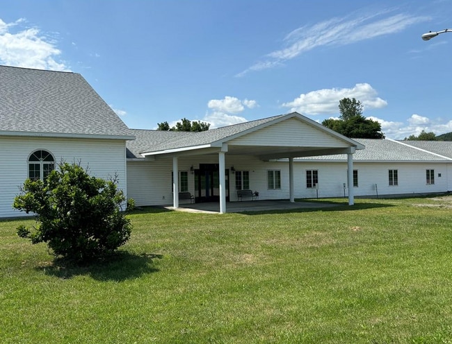

This Property Is For Sale
Current Lease Availabilities
NEARBY LISTINGS FOR SALE OR LEASE
Property Detail
6017 Magee Rd
Corning, NY
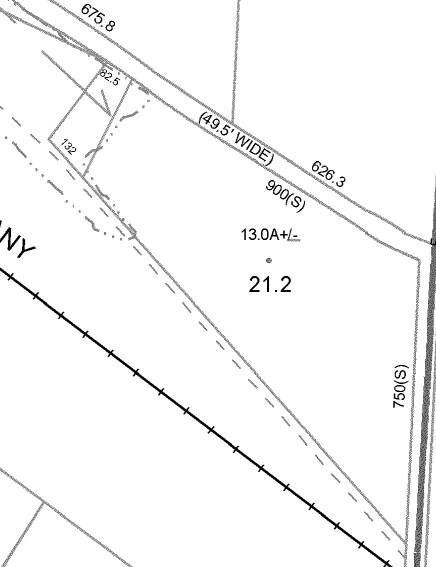
13 A
465289-182-000-0002-021-200
Steuben
Religious
New York
0
21.200
2024
13 AC
960600
Ithaca/Elmira
15,846 SF
Other Market Areas
DEMOGRAPHICS near 6017 Magee Rd
1 Mile
3 Mile
5 Mile
2024 Total Population
181
8,167
13,124
2029 Population
179
8,000
12,854
Pop Growth 2024-2029
(1.10%)
(2.04%)
(2.06%)
Average Age
43
40
41
2024 Total Households
73
3,448
5,594
HH Growth 2024-2029
(1.37%)
(2.09%)
(2.11%)
Median Household Inc
$55,000
$51,875
$50,386
Avg Household Size
2.40
2.30
2.30
2024 Avg HH Vehicles
2.00
2.00
2.00
Median Home Value
$143,478
$92,831
$92,309
Median Year Built
1962
1948
1948
Nearby Places
Map Layers
Map Styles
 Street
 Aerial
- Restaurants
- Banks
- Shops
- Fitness
- Groceries
Nearby Properties
Address
Land Use
TOTAL SIZE
Lot Size
Zoning
Address
Land Use
TOTAL SIZE
Lot Size
Zoning
66,310 SF
21.70 AC
07 - MIXED
Address
Land Use
TOTAL SIZE
Lot Size
Zoning
216.30 AC
Address
Land Use
TOTAL SIZE
Lot Size
Zoning
96,944 SF
3.95 AC
07 - MIXED
Address
Land Use
TOTAL SIZE
Lot Size
Zoning
Address
Land Use
TOTAL SIZE
Lot Size
Zoning
Address
Land Use
TOTAL SIZE
Lot Size
Zoning
18.57 AC
Address
Land Use
TOTAL SIZE
Lot Size
Zoning
70,000 SF
28.70 AC
I-1
Address
Land Use
TOTAL SIZE
Lot Size
Zoning
147,500 SF
3.58 AC
B-1
Address
Land Use
TOTAL SIZE
Lot Size
Zoning
6,516 SF
5.76 AC
Address
Land Use
TOTAL SIZE
Lot Size
Zoning
13,776 SF
1.71 AC
B-2
Address
Land Use
TOTAL SIZE
Lot Size
Zoning
28,634 SF
5.42 AC
B-2
Address
Land Use
TOTAL SIZE
Lot Size
Zoning
36,118 SF
1.62 AC
Address
Land Use
TOTAL SIZE
Lot Size
Zoning
21.72 AC
Address
Land Use
TOTAL SIZE
Lot Size
Zoning
896 SF
31 AC
05
Address
Land Use
TOTAL SIZE
Lot Size
Zoning
2,340 SF
0.34 AC
B-2
Address
Land Use
TOTAL SIZE
Lot Size
Zoning
31,780 SF
1.53 AC
R-3
Address
Land Use
TOTAL SIZE
Lot Size
Zoning
28,000 SF
2.27 AC
I-2
Address
Land Use
TOTAL SIZE
Lot Size
Zoning
8,500 SF
4.90 AC
R-3
Address
Land Use
TOTAL SIZE
Lot Size
Zoning
4.80 AC
Address
Land Use
TOTAL SIZE
Lot Size
Zoning
23,412 SF
1.68 AC
Address
Land Use
TOTAL SIZE
Lot Size
Zoning
14,097 SF
13.85 AC
04
Address
Land Use
TOTAL SIZE
Lot Size
Zoning
39,388 SF
2.80 AC
R-3
Address
Land Use
TOTAL SIZE
Lot Size
Zoning
Address
Land Use
TOTAL SIZE
Lot Size
Zoning
Address
Land Use
TOTAL SIZE
Lot Size
Zoning
20,480 SF
1.47 AC
I-2
Address
Land Use
TOTAL SIZE
Lot Size
Zoning
13,348 SF
0.23 AC
B-2
Address
Land Use
TOTAL SIZE
Lot Size
Zoning
2.55 AC
Address
Land Use
TOTAL SIZE
Lot Size
Zoning
Address
Land Use
TOTAL SIZE
Lot Size
Zoning
The World's #1 Commercial Real Estate Marketplace
Connect with us
© 2026 CoStar Group
The information above has been obtained from sources believed reliable. While we do not doubt its accuracy we have not verified it and make no guarantee, warranty or representation about it. It is your responsibility to independently confirm its accuracy and completeness. Any projections, opinions, assumptions, or estimates used are for example only and do not represent the current or future performance of the property. The value of this transaction to you depends on tax and other factors which should be evaluated by your tax, financial, and legal advisors. You and your advisors should conduct a careful, independent investigation of the property to determine to your satisfaction the suitability of the property for your needs.