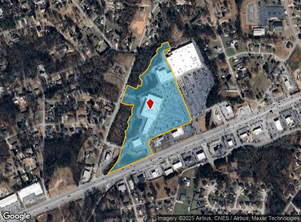
Property Record
6003 Wade Hampton Blvd, Taylors, SC 29687


Current Lease Availabilities
NEARBY LISTINGS FOR SALE OR LEASE
Property Detail
6003 Wade Hampton Blvd
Greenville-Anderson-Mauldin, SC
MAP T009.04
T009.04-01-025.08
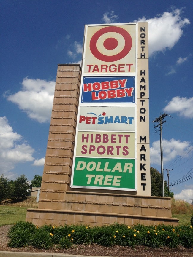
Greenville
Stripcommercialcenter
South Carolina
X
025.08
45045C0342E
17.32 AC
2024
Wade Hampton
2024
Greenville/Spartanburg
002611
DEMOGRAPHICS near 6003 Wade Hampton Blvd
1 Mile
3 Mile
5 Mile
2024 Total Population
4,068
45,510
115,717
2029 Population
4,491
50,051
127,510
Pop Growth 2024-2029
+ 10.40%
+ 9.98%
+ 10.19%
Average Age
40
40
40
2024 Total Households
1,650
18,140
45,552
HH Growth 2024-2029
+ 10.55%
+ 10.07%
+ 10.28%
Median Household Inc
$57,843
$67,581
$70,404
Avg Household Size
2.40
2.50
2.50
2024 Avg HH Vehicles
2.00
2.00
2.00
Median Home Value
$221,510
$228,089
$245,806
Median Year Built
1994
1991
1989
Nearby Places
- Restaurants
- Banks
- Shops
- Fitness
- Groceries
PUBLIC TRANSPORTATION
COMMUTER RAIL
Greenville Amtrak Station (Crescent - Amtrak)
DRIVE
WALK
Distance
Greenville Amtrak Station (Crescent - Amtrak)
18 min
9.8 mi
AIRPORT
Greenville Spartanburg International
DRIVE
WALK
Distance
Greenville Spartanburg International
19 min
8.1 mi
Freight Ports
North Charleston Terminal
DRIVE
WALK
Distance
North Charleston Terminal
239 min
207.9 mi
Nearby Properties
Address
Land Use
TOTAL SIZE
Lot Size
Zoning
Address
Land Use
TOTAL SIZE
Lot Size
Zoning
5.07 AC
C2
Address
Land Use
TOTAL SIZE
Lot Size
Zoning
14.20 AC
UNZONED
Address
Land Use
TOTAL SIZE
Lot Size
Zoning
13.25 AC
I1
Address
Land Use
TOTAL SIZE
Lot Size
Zoning
11.80 AC
R10
Address
Land Use
TOTAL SIZE
Lot Size
Zoning
11.30 AC
R10
Address
Land Use
TOTAL SIZE
Lot Size
Zoning
0.42 AC
OD
Address
Land Use
TOTAL SIZE
Lot Size
Zoning
8.22 AC
I1
Address
Land Use
TOTAL SIZE
Lot Size
Zoning
1.90 AC
I1
Address
Land Use
TOTAL SIZE
Lot Size
Zoning
25.70 AC
R20
Address
Land Use
TOTAL SIZE
Lot Size
Zoning
6.81 AC
RM
Address
Land Use
TOTAL SIZE
Lot Size
Zoning
92.74 AC
R15
Address
Land Use
TOTAL SIZE
Lot Size
Zoning
10.20 AC
S1
Address
Land Use
TOTAL SIZE
Lot Size
Zoning
41.90 AC
RMA
Address
Land Use
TOTAL SIZE
Lot Size
Zoning
5.23 AC
I1
Address
Land Use
TOTAL SIZE
Lot Size
Zoning
14.33 AC
I1
Address
Land Use
TOTAL SIZE
Lot Size
Zoning
22.35 AC
R20
Address
Land Use
TOTAL SIZE
Lot Size
Zoning
532 SF
72.61 AC
I1
Address
Land Use
TOTAL SIZE
Lot Size
Zoning
4.07 AC
OD
Address
Land Use
TOTAL SIZE
Lot Size
Zoning
6.90 AC
I1
Address
Land Use
TOTAL SIZE
Lot Size
Zoning
19.02 AC
RRROW
Address
Land Use
TOTAL SIZE
Lot Size
Zoning
11.70 AC
C2
Address
Land Use
TOTAL SIZE
Lot Size
Zoning
7.12 AC
R15
Address
Land Use
TOTAL SIZE
Lot Size
Zoning
44.37 AC
R15
Address
Land Use
TOTAL SIZE
Lot Size
Zoning
5.15 AC
R15
Address
Land Use
TOTAL SIZE
Lot Size
Zoning
3.56 AC
OD
Address
Land Use
TOTAL SIZE
Lot Size
Zoning
5 AC
C3
Address
Land Use
TOTAL SIZE
Lot Size
Zoning
37.96 AC
RS
Address
Land Use
TOTAL SIZE
Lot Size
Zoning
6.62 AC
I1
Address
Land Use
TOTAL SIZE
Lot Size
Zoning
4.85 AC
I1
Address
Land Use
TOTAL SIZE
Lot Size
Zoning
99.01 AC
I1
The World's #1 Commercial Real Estate Marketplace
Connect with us
© 2025 CoStar Group
The information above has been obtained from sources believed reliable. While we do not doubt its accuracy we have not verified it and make no guarantee, warranty or representation about it. It is your responsibility to independently confirm its accuracy and completeness. Any projections, opinions, assumptions, or estimates used are for example only and do not represent the current or future performance of the property. The value of this transaction to you depends on tax and other factors which should be evaluated by your tax, financial, and legal advisors. You and your advisors should conduct a careful, independent investigation of the property to determine to your satisfaction the suitability of the property for your needs.