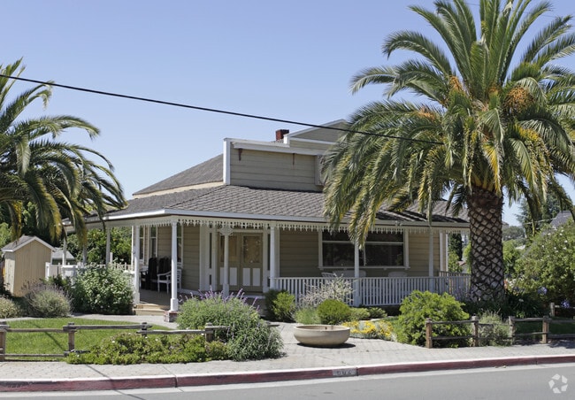
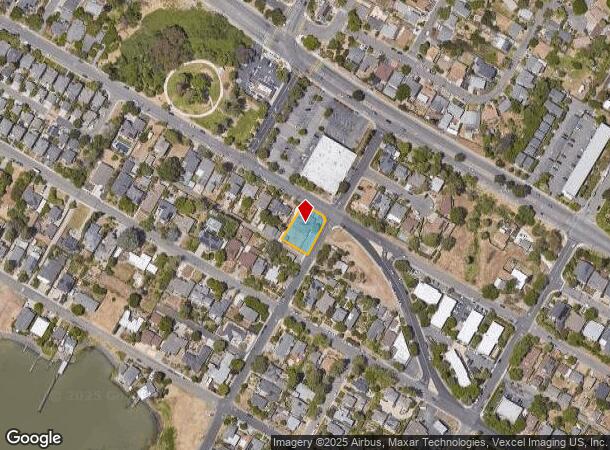
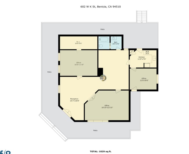
Property Record
602 W K St, Benicia, CA 94510
This Property Is For Sale
NEARBY LISTINGS FOR SALE OR LEASE
Property Detail
602 W K St
Vallejo-Fairfield, CA
Benicia
0087-142-150
BK-BG 00-00
Medicalbuilding
Solano
X
California
06095C0641F
5
2024
0.22 AC
2025
Benicia
252000
North Bay/Santa Rosa
1,226 SF
DEMOGRAPHICS near 602 W K St
1 Mile
3 Mile
5 Mile
2024 Total Population
10,009
36,351
100,194
2029 Population
9,904
35,878
99,071
Pop Growth 2024-2029
(1.05%)
(1.30%)
(1.12%)
Average Age
45
45
42
2024 Total Households
4,379
14,537
37,685
HH Growth 2024-2029
(1.10%)
(1.33%)
(1.12%)
Median Household Inc
$114,184
$115,676
$94,960
Avg Household Size
2.30
2.50
2.60
2024 Avg HH Vehicles
2.00
2.00
2.00
Median Home Value
$746,951
$734,797
$659,488
Median Year Built
1976
1981
1974
Nearby Places
Map Layers
Map Styles
 Street
 Aerial
- Restaurants
- Banks
- Shops
- Fitness
- Groceries
PUBLIC TRANSPORTATION
COMMUTER RAIL
DRIVE
WALK
Distance
10 min
6.3 mi
AIRPORT
Metro Oakland International
DRIVE
WALK
Distance
Metro Oakland International
51 min
37.7 mi
San Francisco International
DRIVE
WALK
Distance
San Francisco International
63 min
46.1 mi
Freight Ports
Port of Richmond
DRIVE
WALK
Distance
Port of Richmond
35 min
24.2 mi
Nearby Properties
Address
Land Use
TOTAL SIZE
Lot Size
Zoning
Address
Land Use
TOTAL SIZE
Lot Size
Zoning
324.69 AC
Address
Land Use
TOTAL SIZE
Lot Size
Zoning
1,053 SF
7.78 AC
HI
Address
Land Use
TOTAL SIZE
Lot Size
Zoning
19.90 AC
Address
Land Use
TOTAL SIZE
Lot Size
Zoning
Address
Land Use
TOTAL SIZE
Lot Size
Zoning
160,000 SF
13.67 AC
Address
Land Use
TOTAL SIZE
Lot Size
Zoning
200,888 SF
19.11 AC
MR25
Address
Land Use
TOTAL SIZE
Lot Size
Zoning
22,176 SF
15.14 AC
Address
Land Use
TOTAL SIZE
Lot Size
Zoning
243,000 SF
12.62 AC
Address
Land Use
TOTAL SIZE
Lot Size
Zoning
86,222 SF
39.83 AC
Address
Land Use
TOTAL SIZE
Lot Size
Zoning
12.63 AC
Address
Land Use
TOTAL SIZE
Lot Size
Zoning
19.08 AC
Address
Land Use
TOTAL SIZE
Lot Size
Zoning
13.63 AC
Address
Land Use
TOTAL SIZE
Lot Size
Zoning
488,220 SF
11.88 AC
Address
Land Use
TOTAL SIZE
Lot Size
Zoning
240,000 SF
11.77 AC
Address
Land Use
TOTAL SIZE
Lot Size
Zoning
240,000 SF
9.60 AC
INDUSTRIAL
Address
Land Use
TOTAL SIZE
Lot Size
Zoning
12.80 AC
Address
Land Use
TOTAL SIZE
Lot Size
Zoning
115,292 SF
9.85 AC
Address
Land Use
TOTAL SIZE
Lot Size
Zoning
100,547 SF
7.51 AC
Address
Land Use
TOTAL SIZE
Lot Size
Zoning
120,000 SF
5.52 AC
Address
Land Use
TOTAL SIZE
Lot Size
Zoning
15,032 SF
47.47 AC
Address
Land Use
TOTAL SIZE
Lot Size
Zoning
1,536,263 SF
6.57 AC
Address
Land Use
TOTAL SIZE
Lot Size
Zoning
77,841 SF
7.67 AC
Address
Land Use
TOTAL SIZE
Lot Size
Zoning
3.75 AC
RM
Address
Land Use
TOTAL SIZE
Lot Size
Zoning
1,536,263 SF
9.65 AC
Address
Land Use
TOTAL SIZE
Lot Size
Zoning
21,410 SF
19.35 AC
Address
Land Use
TOTAL SIZE
Lot Size
Zoning
1,536,263 SF
6 AC
Address
Land Use
TOTAL SIZE
Lot Size
Zoning
82,040 SF
8.22 AC
INDUSTRIAL
Address
Land Use
TOTAL SIZE
Lot Size
Zoning
35,434 SF
1.66 AC
Address
Land Use
TOTAL SIZE
Lot Size
Zoning
5.17 AC
INDUSTRIAL
Address
Land Use
TOTAL SIZE
Lot Size
Zoning
89,400 SF
1.83 AC
The World's #1 Commercial Real Estate Marketplace
Connect with us
© 2026 CoStar Group
The information above has been obtained from sources believed reliable. While we do not doubt its accuracy we have not verified it and make no guarantee, warranty or representation about it. It is your responsibility to independently confirm its accuracy and completeness. Any projections, opinions, assumptions, or estimates used are for example only and do not represent the current or future performance of the property. The value of this transaction to you depends on tax and other factors which should be evaluated by your tax, financial, and legal advisors. You and your advisors should conduct a careful, independent investigation of the property to determine to your satisfaction the suitability of the property for your needs.