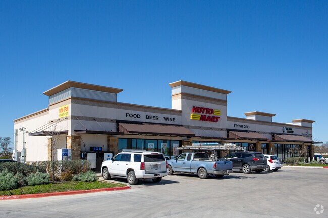
Property Record
6020 Fm 1660, Hutto, TX 78634

Property Detail
6020 Fm 1660
Austin-Round Rock-San Marcos, TX
S8181 - HUTTOPARKE SEC 1, BLOCK C, LOT 112, ACRES 6.12
R431569
Williamson
Commercialnec
Texas
AE The base floodplain where base flood elevations are provided. AE Zones are now used on new format FIRMs instead of A1-A30 Zones.
112
2024
6.12 AC
2025
Georgetown
020812
Austin
7,020 SF
NEARBY LISTINGS FOR SALE OR LEASE
DEMOGRAPHICS near 6020 Fm 1660
1 mile
3 mile
5 mile
2025 Total Population
9,730
35,103
82,184
2030 Population
11,354
40,904
95,041
Pop Growth 2025-2030
+ 16.69%
+ 16.53%
+ 15.64%
Average Age
35
35
36
2025 Total Households
3,065
11,139
26,991
HH Growth 2025-2030
+ 17.16%
+ 16.90%
+ 16.11%
Median Household Inc
$119,623
$122,905
$129,999
Avg Household Size
3.10
3.10
3.00
2025 Avg HH Vehicles
3.00
2.00
2.00
Median Home Value
$406,442
$407,378
$439,026
Median Year Built
2010
2010
2010
Nearby Places
Map Layers
Map Styles
 Street
 Aerial
Transit
 Traffic
 Biking
Places
Listings with unknown addresses are not visible on the map
- Restaurants
- Banks
- Shops
- Fitness
- Groceries
PUBLIC TRANSPORTATION
COMMUTER RAIL
Drive
Walk
Distance
14 min
9.9 mi
AIRPORT
Austin-Bergstrom International
Drive
Walk
Distance
Austin-Bergstrom International
44 min
34.3 mi
SALE & LEASE HISTORY
LISTING DATE
SALE/LEASE

Oct 09, 2018
For Lease
Jun 24, 2019
For Lease
Jun 16, 2017
For Lease
Nearby Properties
Address
Land Use
TOTAL SIZE
Lot Size
Zoning
Address
Land Use
TOTAL SIZE
Lot Size
Zoning
533,782 SF
79.41 AC
Address
Land Use
TOTAL SIZE
Lot Size
Zoning
243,097 SF
15.73 AC
Address
Land Use
TOTAL SIZE
Lot Size
Zoning
302,465 SF
15.79 AC
Address
Land Use
TOTAL SIZE
Lot Size
Zoning
29,616 SF
158.84 AC
Address
Land Use
TOTAL SIZE
Lot Size
Zoning
253,225 SF
12.25 AC
Address
Land Use
TOTAL SIZE
Lot Size
Zoning
301,721 SF
16.54 AC
Address
Land Use
TOTAL SIZE
Lot Size
Zoning
304,814 SF
17.04 AC
Address
Land Use
TOTAL SIZE
Lot Size
Zoning
76.14 AC
Address
Land Use
TOTAL SIZE
Lot Size
Zoning
230,841 SF
17.51 AC
Address
Land Use
TOTAL SIZE
Lot Size
Zoning
183,310 SF
10.78 AC
Address
Land Use
TOTAL SIZE
Lot Size
Zoning
266,428 SF
58.60 AC
Address
Land Use
TOTAL SIZE
Lot Size
Zoning
195,520 SF
14.89 AC
Address
Land Use
TOTAL SIZE
Lot Size
Zoning
243,097 SF
12.53 AC
Address
Land Use
TOTAL SIZE
Lot Size
Zoning
154,528 SF
7.23 AC
Address
Land Use
TOTAL SIZE
Lot Size
Zoning
220,850 SF
12.06 AC
Address
Land Use
TOTAL SIZE
Lot Size
Zoning
161,190 SF
8.82 AC
Address
Land Use
TOTAL SIZE
Lot Size
Zoning
297,577 SF
28.22 AC
Address
Land Use
TOTAL SIZE
Lot Size
Zoning
535,408 SF
30.16 AC
Address
Land Use
TOTAL SIZE
Lot Size
Zoning
147,230 SF
8.05 AC
Address
Land Use
TOTAL SIZE
Lot Size
Zoning
109,908 SF
7.94 AC
Address
Land Use
TOTAL SIZE
Lot Size
Zoning
16.70 AC
Address
Land Use
TOTAL SIZE
Lot Size
Zoning
14.30 AC
Address
Land Use
TOTAL SIZE
Lot Size
Zoning
193,933 SF
14.25 AC
Address
Land Use
TOTAL SIZE
Lot Size
Zoning
108,422 SF
15.72 AC
Address
Land Use
TOTAL SIZE
Lot Size
Zoning
35,187 SF
5.57 AC
Address
Land Use
TOTAL SIZE
Lot Size
Zoning
49,841 SF
74.93 AC
Address
Land Use
TOTAL SIZE
Lot Size
Zoning
154,752 SF
0.90 AC
Address
Land Use
TOTAL SIZE
Lot Size
Zoning
140,233 SF
12.63 AC
Address
Land Use
TOTAL SIZE
Lot Size
Zoning
114,374 SF
15 AC
Address
Land Use
TOTAL SIZE
Lot Size
Zoning
21,183 SF
3.70 AC
The World's #1 Commercial Real Estate Marketplace
Connect with us
© 2026 CoStar Group
The information above has been obtained from sources believed reliable. While we do not doubt its accuracy we have not verified it and make no guarantee, warranty or representation about it. It is your responsibility to independently confirm its accuracy and completeness. Any projections, opinions, assumptions, or estimates used are for example only and do not represent the current or future performance of the property. The value of this transaction to you depends on tax and other factors which should be evaluated by your tax, financial, and legal advisors. You and your advisors should conduct a careful, independent investigation of the property to determine to your satisfaction the suitability of the property for your needs.