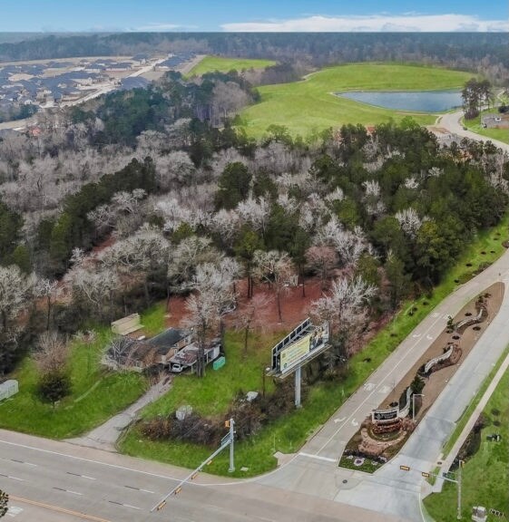
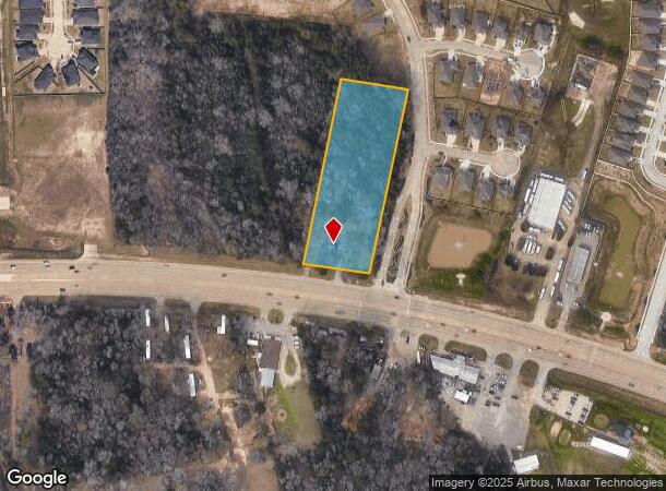
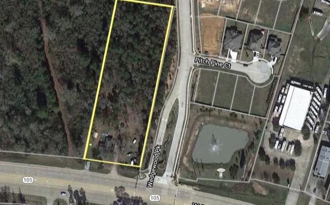
Property Record
6020 W Davis St, Conroe, TX 77304
NEARBY LISTINGS FOR SALE OR LEASE
Property Detail
6020 W Davis St
0256-00-00200
Herndon P H
Commercialnec
A0256 - HERNDON P H, TRACT 2, ACRES 2.856
X
Montgomery
48339C0360G
Texas
2024
2.85 AC
2025
Outlying Montgomery Cnty
693703
Houston
1,680 SF
Houston-The Woodlands-Sugar Land, TX
DEMOGRAPHICS near 6020 W Davis St
1 Mile
3 Mile
5 Mile
2024 Total Population
2,765
26,329
83,560
2029 Population
3,473
32,629
103,129
Pop Growth 2024-2029
+ 25.61%
+ 23.93%
+ 23.42%
Average Age
40
39
39
2024 Total Households
1,114
10,415
31,244
HH Growth 2024-2029
+ 25.67%
+ 24.05%
+ 24.03%
Median Household Inc
$74,536
$79,655
$74,440
Avg Household Size
2.50
2.50
2.60
2024 Avg HH Vehicles
2.00
2.00
2.00
Median Home Value
$299,854
$306,575
$299,385
Median Year Built
2010
2010
2005
Nearby Places
Map Layers
Map Styles
 Street
 Aerial
- Restaurants
- Banks
- Shops
- Fitness
- Groceries
PUBLIC TRANSPORTATION
AIRPORT
George Bush Intcntl/Houston
DRIVE
WALK
Distance
George Bush Intcntl/Houston
45 min
35.7 mi
Freight Ports
Port of Houston
DRIVE
WALK
Distance
Port of Houston
68 min
51.4 mi
SALE & LEASE HISTORY
LISTING DATE
SALE/LEASE

Oct 29, 2021
For Sale
Jun 08, 2022
For Sale
Jan 26, 2022
For Sale
Nearby Properties
Address
Land Use
TOTAL SIZE
Lot Size
Zoning
Address
Land Use
TOTAL SIZE
Lot Size
Zoning
419,016 SF
26 AC
Address
Land Use
TOTAL SIZE
Lot Size
Zoning
308,438 SF
14.35 AC
Address
Land Use
TOTAL SIZE
Lot Size
Zoning
322,588 SF
14.77 AC
Address
Land Use
TOTAL SIZE
Lot Size
Zoning
280,904 SF
12 AC
Address
Land Use
TOTAL SIZE
Lot Size
Zoning
294,336 SF
20.39 AC
Address
Land Use
TOTAL SIZE
Lot Size
Zoning
275,000 SF
13.65 AC
Address
Land Use
TOTAL SIZE
Lot Size
Zoning
204,716 SF
15.51 AC
Address
Land Use
TOTAL SIZE
Lot Size
Zoning
206,841 SF
23.44 AC
Address
Land Use
TOTAL SIZE
Lot Size
Zoning
258,100 SF
12.04 AC
1
Address
Land Use
TOTAL SIZE
Lot Size
Zoning
229,345 SF
12.36 AC
1
Address
Land Use
TOTAL SIZE
Lot Size
Zoning
134,935 SF
10.50 AC
1
Address
Land Use
TOTAL SIZE
Lot Size
Zoning
250,716 SF
11.17 AC
1
Address
Land Use
TOTAL SIZE
Lot Size
Zoning
235,826 SF
15.29 AC
Address
Land Use
TOTAL SIZE
Lot Size
Zoning
134,621 SF
26.37 AC
Address
Land Use
TOTAL SIZE
Lot Size
Zoning
313,974 SF
25.03 AC
1
Address
Land Use
TOTAL SIZE
Lot Size
Zoning
157,996 SF
9 AC
Address
Land Use
TOTAL SIZE
Lot Size
Zoning
287,364 SF
23.45 AC
4
Address
Land Use
TOTAL SIZE
Lot Size
Zoning
174,324 SF
6.66 AC
1
Address
Land Use
TOTAL SIZE
Lot Size
Zoning
151,806 SF
9 AC
1
Address
Land Use
TOTAL SIZE
Lot Size
Zoning
221,890 SF
17.18 AC
Address
Land Use
TOTAL SIZE
Lot Size
Zoning
87,864 SF
22.43 AC
Address
Land Use
TOTAL SIZE
Lot Size
Zoning
114,349 SF
6.50 AC
1
Address
Land Use
TOTAL SIZE
Lot Size
Zoning
239,104 SF
65.54 AC
1
Address
Land Use
TOTAL SIZE
Lot Size
Zoning
114,547 SF
57.94 AC
1
Address
Land Use
TOTAL SIZE
Lot Size
Zoning
114,101 SF
43.80 AC
Address
Land Use
TOTAL SIZE
Lot Size
Zoning
65,004 SF
7.49 AC
1
Address
Land Use
TOTAL SIZE
Lot Size
Zoning
109,998 SF
13.20 AC
Address
Land Use
TOTAL SIZE
Lot Size
Zoning
402,840 SF
26.73 AC
Address
Land Use
TOTAL SIZE
Lot Size
Zoning
190,000 SF
7.54 AC
The World's #1 Commercial Real Estate Marketplace
Connect with us
© 2025 CoStar Group
The information above has been obtained from sources believed reliable. While we do not doubt its accuracy we have not verified it and make no guarantee, warranty or representation about it. It is your responsibility to independently confirm its accuracy and completeness. Any projections, opinions, assumptions, or estimates used are for example only and do not represent the current or future performance of the property. The value of this transaction to you depends on tax and other factors which should be evaluated by your tax, financial, and legal advisors. You and your advisors should conduct a careful, independent investigation of the property to determine to your satisfaction the suitability of the property for your needs.