Property Record
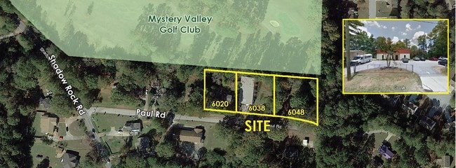
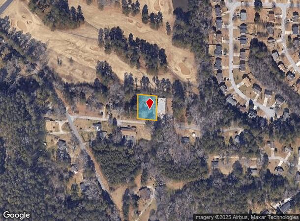
6020 Paul Rd, Lithonia, GA 30058
NEARBY LISTINGS FOR SALE OR LEASE
Property Detail
6020 Paul Rd
16-094-01-074
DeKalb
Commercialnec
Georgia
X
74
13089C0094K
0.46 AC
2025
Stone Mtn/Clarkston
2025
Atlanta
023329
Atlanta-Sandy Springs-Roswell, GA
1,816 SF
DEMOGRAPHICS near 6020 Paul Rd
1 Mile
3 Mile
5 Mile
2024 Total Population
5,164
73,113
184,750
2029 Population
5,117
72,475
183,778
Pop Growth 2024-2029
(0.91%)
(0.87%)
(0.53%)
Average Age
40
39
38
2024 Total Households
1,776
25,454
67,527
HH Growth 2024-2029
(0.90%)
(0.94%)
(0.60%)
Median Household Inc
$73,887
$66,632
$58,456
Avg Household Size
2.90
2.80
2.70
2024 Avg HH Vehicles
2.00
2.00
2.00
Median Home Value
$243,762
$187,986
$198,234
Median Year Built
1996
1986
1986
Nearby Places
Map Layers
Map Styles
 Street
 Aerial
- Restaurants
- Banks
- Shops
- Fitness
- Groceries
PUBLIC TRANSPORTATION
AIRPORT
Hartsfield - Jackson Atlanta International
DRIVE
WALK
Distance
Hartsfield - Jackson Atlanta International
39 min
22.3 mi
Freight Ports
Georgia Ports - Savannah
DRIVE
WALK
Distance
Georgia Ports - Savannah
290 min
245.7 mi
SALE & LEASE HISTORY
LISTING DATE
SALE/LEASE

Sep 23, 2019
For Sale
Nearby Properties
Address
Land Use
TOTAL SIZE
Lot Size
Zoning
Address
Land Use
TOTAL SIZE
Lot Size
Zoning
614,505 SF
97.30 AC
Address
Land Use
TOTAL SIZE
Lot Size
Zoning
764,622 SF
48.38 AC
M
Address
Land Use
TOTAL SIZE
Lot Size
Zoning
271,666 SF
33.72 AC
RM100
Address
Land Use
TOTAL SIZE
Lot Size
Zoning
81,537 SF
9.27 AC
C1
Address
Land Use
TOTAL SIZE
Lot Size
Zoning
34,138 SF
10.97 AC
MR1
Address
Land Use
TOTAL SIZE
Lot Size
Zoning
175,082 SF
14.87 AC
X
Address
Land Use
TOTAL SIZE
Lot Size
Zoning
210,070 SF
14.81 AC
RM100
Address
Land Use
TOTAL SIZE
Lot Size
Zoning
174,655 SF
14.12 AC
X
Address
Land Use
TOTAL SIZE
Lot Size
Zoning
7,384 SF
15.80 AC
M
Address
Land Use
TOTAL SIZE
Lot Size
Zoning
215,422 SF
33.84 AC
M
Address
Land Use
TOTAL SIZE
Lot Size
Zoning
227,648 SF
14.56 AC
X
Address
Land Use
TOTAL SIZE
Lot Size
Zoning
72,755 SF
5.17 AC
C1
Address
Land Use
TOTAL SIZE
Lot Size
Zoning
116,473 SF
15.63 AC
C-1
Address
Land Use
TOTAL SIZE
Lot Size
Zoning
33,448 SF
2.07 AC
C-1
Address
Land Use
TOTAL SIZE
Lot Size
Zoning
207,446 SF
12.21 AC
M
Address
Land Use
TOTAL SIZE
Lot Size
Zoning
253,861 SF
19.28 AC
X
Address
Land Use
TOTAL SIZE
Lot Size
Zoning
128,508 SF
11.62 AC
RCD
Address
Land Use
TOTAL SIZE
Lot Size
Zoning
55,604 SF
4.85 AC
C-3
Address
Land Use
TOTAL SIZE
Lot Size
Zoning
142,160 SF
9.50 AC
M
Address
Land Use
TOTAL SIZE
Lot Size
Zoning
13,232 SF
205.25 AC
X
Address
Land Use
TOTAL SIZE
Lot Size
Zoning
78,600 SF
4.99 AC
M
Address
Land Use
TOTAL SIZE
Lot Size
Zoning
150,000 SF
13.24 AC
M
Address
Land Use
TOTAL SIZE
Lot Size
Zoning
93.79 AC
RM100
Address
Land Use
TOTAL SIZE
Lot Size
Zoning
38,838 SF
5.02 AC
X
Address
Land Use
TOTAL SIZE
Lot Size
Zoning
65,972 SF
0.02 AC
C1
Address
Land Use
TOTAL SIZE
Lot Size
Zoning
112,474 SF
9.20 AC
M
Address
Land Use
TOTAL SIZE
Lot Size
Zoning
94,581 SF
5.58 AC
M
Address
Land Use
TOTAL SIZE
Lot Size
Zoning
57,399 SF
3.76 AC
M
Address
Land Use
TOTAL SIZE
Lot Size
Zoning
99,876 SF
11.81 AC
M2
Address
Land Use
TOTAL SIZE
Lot Size
Zoning
74,768 SF
9.65 AC
C1
The World's #1 Commercial Real Estate Marketplace
Connect with us
© 2025 CoStar Group
The information above has been obtained from sources believed reliable. While we do not doubt its accuracy we have not verified it and make no guarantee, warranty or representation about it. It is your responsibility to independently confirm its accuracy and completeness. Any projections, opinions, assumptions, or estimates used are for example only and do not represent the current or future performance of the property. The value of this transaction to you depends on tax and other factors which should be evaluated by your tax, financial, and legal advisors. You and your advisors should conduct a careful, independent investigation of the property to determine to your satisfaction the suitability of the property for your needs.