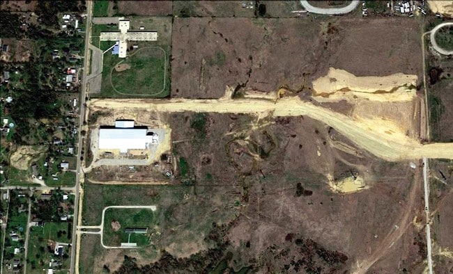
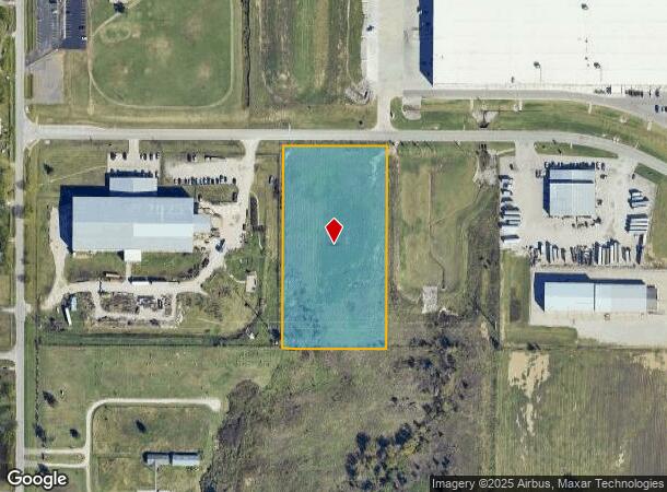
Property Record
5557 S 65Th Ave W, Tulsa, OK 74107
NEARBY LISTINGS FOR SALE OR LEASE
-
-
View all Tulsa listings for sale on LoopNet.com
Property Detail
5557 S 65Th Ave W
99232-92-32-35270
Unplatted
Warehouse
PRT SE SW NW BEG 581.37N & 751E SWC SW NW TH E300.14 S581.24 W300 N581.27 POB SEC 32 19 12 4.01 ACS
X
Tulsa
40143C0333L
Oklahoma
2025
4.01 AC
2025
West
004700
Tulsa
10,410 SF
Tulsa, OK
DEMOGRAPHICS near 5557 S 65Th Ave W
1 Mile
3 Mile
5 Mile
2024 Total Population
949
22,611
69,950
2029 Population
986
23,462
72,569
Pop Growth 2024-2029
+ 3.90%
+ 3.76%
+ 3.74%
Average Age
41
40
39
2024 Total Households
357
8,667
29,372
HH Growth 2024-2029
+ 3.92%
+ 3.80%
+ 3.69%
Median Household Inc
$63,068
$57,349
$53,072
Avg Household Size
2.60
2.50
2.30
2024 Avg HH Vehicles
2.00
2.00
2.00
Median Home Value
$174,478
$149,638
$157,569
Median Year Built
1972
1971
1975
Nearby Places
Map Layers
Map Styles
 Street
 Aerial
- Restaurants
- Banks
- Shops
- Fitness
- Groceries
PUBLIC TRANSPORTATION
AIRPORT
Tulsa International
DRIVE
WALK
Distance
Tulsa International
24 min
16.5 mi
Freight Ports
Tulsa Port Of Catoosa
DRIVE
WALK
Distance
Tulsa Port Of Catoosa
34 min
25.8 mi
SALE & LEASE HISTORY
LISTING DATE
SALE/LEASE

Sep 24, 2016
For Sale
Nearby Properties
Address
Land Use
TOTAL SIZE
Lot Size
Zoning
Address
Land Use
TOTAL SIZE
Lot Size
Zoning
1,134,776 SF
35.85 AC
CN
Address
Land Use
TOTAL SIZE
Lot Size
Zoning
119,056 SF
28.06 AC
CM
Address
Land Use
TOTAL SIZE
Lot Size
Zoning
110,382 SF
9.81 AC
RS3
Address
Land Use
TOTAL SIZE
Lot Size
Zoning
143,520 SF
25.14 AC
IM
Address
Land Use
TOTAL SIZE
Lot Size
Zoning
47,670 SF
10.05 AC
RS
Address
Land Use
TOTAL SIZE
Lot Size
Zoning
22,078 SF
5.08 AC
CS
Address
Land Use
TOTAL SIZE
Lot Size
Zoning
32,847 SF
28.03 AC
RS3
Address
Land Use
TOTAL SIZE
Lot Size
Zoning
23,269 SF
263.40 AC
NCU
Address
Land Use
TOTAL SIZE
Lot Size
Zoning
32,722 SF
8.40 AC
RS3
Address
Land Use
TOTAL SIZE
Lot Size
Zoning
1,025 SF
64.46 AC
AG
Address
Land Use
TOTAL SIZE
Lot Size
Zoning
251,601 SF
16.75 AC
RM1
Address
Land Use
TOTAL SIZE
Lot Size
Zoning
117,372 SF
11.87 AC
CN
Address
Land Use
TOTAL SIZE
Lot Size
Zoning
20,771 SF
1.11 AC
RS3
Address
Land Use
TOTAL SIZE
Lot Size
Zoning
370,891 SF
26.43 AC
IM
Address
Land Use
TOTAL SIZE
Lot Size
Zoning
16,000 SF
5 AC
CS
Address
Land Use
TOTAL SIZE
Lot Size
Zoning
69,616 SF
1.86 AC
RS3
Address
Land Use
TOTAL SIZE
Lot Size
Zoning
38,940 SF
16.24 AC
Address
Land Use
TOTAL SIZE
Lot Size
Zoning
15,066 SF
2.16 AC
RS3
Address
Land Use
TOTAL SIZE
Lot Size
Zoning
31,600 SF
13.46 AC
Address
Land Use
TOTAL SIZE
Lot Size
Zoning
25,685 SF
5.04 AC
Address
Land Use
TOTAL SIZE
Lot Size
Zoning
40,069 SF
4.22 AC
RM0
Address
Land Use
TOTAL SIZE
Lot Size
Zoning
19,188 SF
3.87 AC
RS3
Address
Land Use
TOTAL SIZE
Lot Size
Zoning
15,662 SF
0.78 AC
RS3
Address
Land Use
TOTAL SIZE
Lot Size
Zoning
25,088 SF
4.77 AC
RS3
Address
Land Use
TOTAL SIZE
Lot Size
Zoning
41,444 SF
4.71 AC
CG
Address
Land Use
TOTAL SIZE
Lot Size
Zoning
62.43 AC
RS3
Address
Land Use
TOTAL SIZE
Lot Size
Zoning
23,100 SF
30 AC
IM
Address
Land Use
TOTAL SIZE
Lot Size
Zoning
9,282 SF
4.83 AC
Address
Land Use
TOTAL SIZE
Lot Size
Zoning
14,900 SF
0.78 AC
RS3
Address
Land Use
TOTAL SIZE
Lot Size
Zoning
82,140 SF
10.61 AC
IL
The World's #1 Commercial Real Estate Marketplace
Connect with us
© 2026 CoStar Group
The information above has been obtained from sources believed reliable. While we do not doubt its accuracy we have not verified it and make no guarantee, warranty or representation about it. It is your responsibility to independently confirm its accuracy and completeness. Any projections, opinions, assumptions, or estimates used are for example only and do not represent the current or future performance of the property. The value of this transaction to you depends on tax and other factors which should be evaluated by your tax, financial, and legal advisors. You and your advisors should conduct a careful, independent investigation of the property to determine to your satisfaction the suitability of the property for your needs.