Property Record
6021 Troy Hwy, Montgomery, AL 36116

NEARBY LISTINGS FOR SALE OR LEASE
-
-
View all Montgomery listings for sale on LoopNet.com
Property Detail
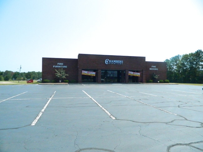
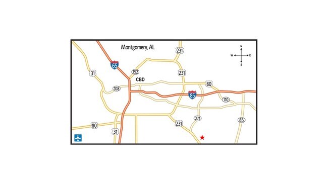
6021 Troy Hwy
Montgomery, AL
Don Chambers 2
16-03-08-3-000-002.007
1603083000002007
Publicstorage
Montgomery
AE
Alabama
01101C0241J
1a
2025
3.20 AC
2025
North Montgomery
005610
Montgomery
25,540 SF
DEMOGRAPHICS near 6021 Troy Hwy
1 Mile
3 Mile
5 Mile
2024 Total Population
564
12,068
57,814
2029 Population
553
11,797
55,769
Pop Growth 2024-2029
(1.95%)
(2.25%)
(3.54%)
Average Age
37
36
37
2024 Total Households
218
4,748
24,065
HH Growth 2024-2029
(1.83%)
(2.36%)
(3.70%)
Median Household Inc
$69,772
$68,579
$57,765
Avg Household Size
2.60
2.50
2.30
2024 Avg HH Vehicles
2.00
2.00
2.00
Median Home Value
$211,905
$210,241
$185,175
Median Year Built
1994
1998
1991
Nearby Places
Map Layers
Map Styles
 Street
 Aerial
- Restaurants
- Banks
- Shops
- Fitness
- Groceries
PUBLIC TRANSPORTATION
AIRPORT
Montgomery Regional (Dannelly Field)
DRIVE
WALK
Distance
Montgomery Regional (Dannelly Field)
19 min
14.6 mi
Freight Ports
Port of Panama City
DRIVE
WALK
Distance
Port of Panama City
223 min
177.8 mi
SALE & LEASE HISTORY
LISTING DATE
SALE/LEASE

Aug 19, 2019
For Sale
Nearby Properties
Address
Land Use
TOTAL SIZE
Lot Size
Zoning
Address
Land Use
TOTAL SIZE
Lot Size
Zoning
4,998 SF
27.50 AC
R-65-M
Address
Land Use
TOTAL SIZE
Lot Size
Zoning
47,292 SF
63.99 AC
Address
Land Use
TOTAL SIZE
Lot Size
Zoning
23,642 SF
13.70 AC
PUD
Address
Land Use
TOTAL SIZE
Lot Size
Zoning
10,317 SF
16.70 AC
AGR-1
Address
Land Use
TOTAL SIZE
Lot Size
Zoning
30,536 SF
18.06 AC
AGR-1
Address
Land Use
TOTAL SIZE
Lot Size
Zoning
7,683 SF
8.11 AC
PUD
Address
Land Use
TOTAL SIZE
Lot Size
Zoning
44,082 SF
5.95 AC
Address
Land Use
TOTAL SIZE
Lot Size
Zoning
6,866 SF
5.39 AC
PUD
Address
Land Use
TOTAL SIZE
Lot Size
Zoning
3,358 SF
123.85 AC
AGR-1
Address
Land Use
TOTAL SIZE
Lot Size
Zoning
84,279 SF
14.27 AC
Address
Land Use
TOTAL SIZE
Lot Size
Zoning
1,585 SF
13.86 AC
PUD
Address
Land Use
TOTAL SIZE
Lot Size
Zoning
43,646 SF
22.54 AC
AGR-1
Address
Land Use
TOTAL SIZE
Lot Size
Zoning
25.72 AC
Address
Land Use
TOTAL SIZE
Lot Size
Zoning
43,139 SF
0.72 AC
T5
Address
Land Use
TOTAL SIZE
Lot Size
Zoning
4,608 SF
5.08 AC
AGR-1
Address
Land Use
TOTAL SIZE
Lot Size
Zoning
118 AC
Address
Land Use
TOTAL SIZE
Lot Size
Zoning
206.60 AC
PUD
Address
Land Use
TOTAL SIZE
Lot Size
Zoning
20,595 SF
17.67 AC
PUD
Address
Land Use
TOTAL SIZE
Lot Size
Zoning
30,967 SF
0.09 AC
T4-0
Address
Land Use
TOTAL SIZE
Lot Size
Zoning
165,954 SF
23.10 AC
M-1
Address
Land Use
TOTAL SIZE
Lot Size
Zoning
18,080 SF
0.51 AC
Address
Land Use
TOTAL SIZE
Lot Size
Zoning
1,064 SF
7.70 AC
R-75-S
Address
Land Use
TOTAL SIZE
Lot Size
Zoning
160.40 AC
PUD
Address
Land Use
TOTAL SIZE
Lot Size
Zoning
12,143 SF
0.22 AC
PUD
Address
Land Use
TOTAL SIZE
Lot Size
Zoning
12,378 SF
0.25 AC
PUD
Address
Land Use
TOTAL SIZE
Lot Size
Zoning
18,193 SF
0.42 AC
T5
Address
Land Use
TOTAL SIZE
Lot Size
Zoning
8.80 AC
PUD
Address
Land Use
TOTAL SIZE
Lot Size
Zoning
10,328 SF
0.23 AC
PUD
Address
Land Use
TOTAL SIZE
Lot Size
Zoning
85,253 SF
6 AC
M-1
Address
Land Use
TOTAL SIZE
Lot Size
Zoning
10,402 SF
0.20 AC
PUD
The World's #1 Commercial Real Estate Marketplace
Connect with us
© 2026 CoStar Group
The information above has been obtained from sources believed reliable. While we do not doubt its accuracy we have not verified it and make no guarantee, warranty or representation about it. It is your responsibility to independently confirm its accuracy and completeness. Any projections, opinions, assumptions, or estimates used are for example only and do not represent the current or future performance of the property. The value of this transaction to you depends on tax and other factors which should be evaluated by your tax, financial, and legal advisors. You and your advisors should conduct a careful, independent investigation of the property to determine to your satisfaction the suitability of the property for your needs.