Property Record
6025 Genoa Red Bluff Rd, Pasadena, TX 77507
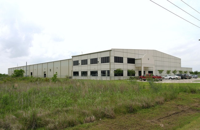

Property Detail
6025 Genoa Red Bluff Rd
1351720010001
RES A BLK 1 TECHEMET COMMERCIAL PARK R/P
Lightindustrial
HARRIS
AE The base floodplain where base flood elevations are provided. AE Zones are now used on new format FIRMs instead of A1-A30 Zones.
Texas
2025
20.14 AC
2025
East-Southeast Far
343700
Houston
330,030 SF
Houston-Pasadena-The Woodlands, TX
NEARBY LISTINGS FOR SALE OR LEASE
DEMOGRAPHICS near 6025 Genoa Red Bluff Rd
1 mile
3 mile
5 mile
2025 Total Population
2,833
62,405
161,191
2030 Population
3,035
66,670
171,958
Pop Growth 2025-2030
+ 7.13%
+ 6.83%
+ 6.68%
Average Age
40
39
39
2025 Total Households
1,006
22,076
58,040
HH Growth 2025-2030
+ 7.36%
+ 6.99%
+ 6.79%
Median Household Inc
$137,938
$98,802
$93,992
Avg Household Size
2.80
2.80
2.70
2025 Avg HH Vehicles
2.00
2.00
2.00
Median Home Value
$351,320
$289,872
$288,692
Median Year Built
1995
1990
1986
Nearby Places
Map Layers
Map Styles
 Street
 Aerial
Layers
 Traffic
 Biking
Places
Listings with unknown addresses are not visible on the map
- Restaurants
- Banks
- Shops
- Fitness
- Groceries
PUBLIC TRANSPORTATION
AIRPORT
William P Hobby
Drive
Walk
Distance
William P Hobby
27 min
12.9 mi
George Bush Intcntl/Houston
Drive
Walk
Distance
George Bush Intcntl/Houston
45 min
34.1 mi
Freight Ports
Port of Houston
Drive
Walk
Distance
Port of Houston
28 min
15.7 mi
Nearby Properties
Address
Land Use
TOTAL SIZE
Lot Size
Zoning
Address
Land Use
TOTAL SIZE
Lot Size
Zoning
Address
Land Use
TOTAL SIZE
Lot Size
Zoning
Address
Land Use
TOTAL SIZE
Lot Size
Zoning
20.83 AC
Address
Land Use
TOTAL SIZE
Lot Size
Zoning
47.21 AC
Address
Land Use
TOTAL SIZE
Lot Size
Zoning
914.75 AC
Address
Land Use
TOTAL SIZE
Lot Size
Zoning
767,630 SF
41.71 AC
Address
Land Use
TOTAL SIZE
Lot Size
Zoning
343,865 SF
16.92 AC
Address
Land Use
TOTAL SIZE
Lot Size
Zoning
642,432 SF
41.55 AC
Address
Land Use
TOTAL SIZE
Lot Size
Zoning
411,864 SF
12.61 AC
Address
Land Use
TOTAL SIZE
Lot Size
Zoning
562,760 SF
21.90 AC
Address
Land Use
TOTAL SIZE
Lot Size
Zoning
319,549 SF
20.70 AC
Address
Land Use
TOTAL SIZE
Lot Size
Zoning
236,508 SF
24.19 AC
Address
Land Use
TOTAL SIZE
Lot Size
Zoning
54.49 AC
Address
Land Use
TOTAL SIZE
Lot Size
Zoning
Address
Land Use
TOTAL SIZE
Lot Size
Zoning
932.50 AC
Address
Land Use
TOTAL SIZE
Lot Size
Zoning
48.84 AC
Address
Land Use
TOTAL SIZE
Lot Size
Zoning
932.50 AC
Address
Land Use
TOTAL SIZE
Lot Size
Zoning
403,572 SF
24.68 AC
Address
Land Use
TOTAL SIZE
Lot Size
Zoning
2.17 AC
Address
Land Use
TOTAL SIZE
Lot Size
Zoning
173,293 SF
19.70 AC
Address
Land Use
TOTAL SIZE
Lot Size
Zoning
371,072 SF
19.71 AC
Address
Land Use
TOTAL SIZE
Lot Size
Zoning
45.18 AC
Address
Land Use
TOTAL SIZE
Lot Size
Zoning
359,223 SF
17.24 AC
Address
Land Use
TOTAL SIZE
Lot Size
Zoning
112.75 AC
Address
Land Use
TOTAL SIZE
Lot Size
Zoning
369,855 SF
21.68 AC
Address
Land Use
TOTAL SIZE
Lot Size
Zoning
356,565 SF
18.07 AC
Address
Land Use
TOTAL SIZE
Lot Size
Zoning
283,010 SF
14.61 AC
Address
Land Use
TOTAL SIZE
Lot Size
Zoning
46.57 AC
Address
Land Use
TOTAL SIZE
Lot Size
Zoning
295,992 SF
18.50 AC
Address
Land Use
TOTAL SIZE
Lot Size
Zoning
276,029 SF
14.44 AC
The World's #1 Commercial Real Estate Marketplace
Connect with us
© 2026 CoStar Group
The information above has been obtained from sources believed reliable. While we do not doubt its accuracy we have not verified it and make no guarantee, warranty or representation about it. It is your responsibility to independently confirm its accuracy and completeness. Any projections, opinions, assumptions, or estimates used are for example only and do not represent the current or future performance of the property. The value of this transaction to you depends on tax and other factors which should be evaluated by your tax, financial, and legal advisors. You and your advisors should conduct a careful, independent investigation of the property to determine to your satisfaction the suitability of the property for your needs.