Property Record
6025 Merritt Rd, Ypsilanti, MI 48197
NEARBY LISTINGS FOR SALE OR LEASE
Property Detail
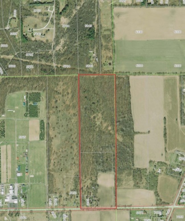
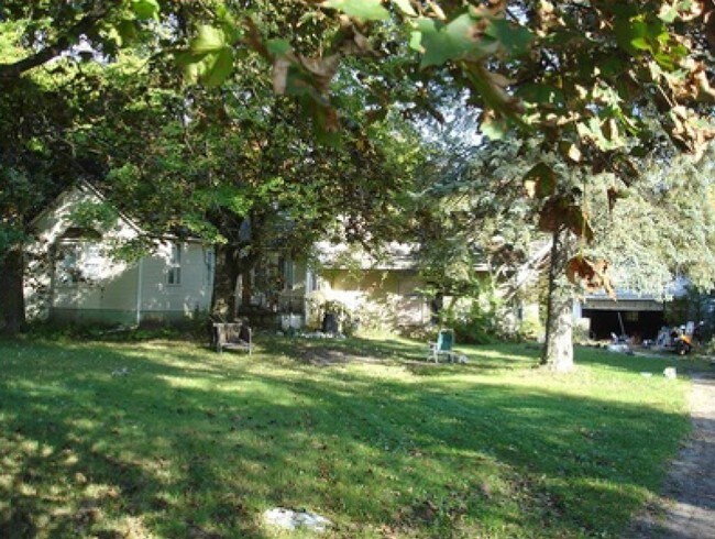
6025 Merritt Rd
11-30-400-014
THE EAST HALF OF THE EAST HALF OF THE SOUTHEAST QUARTER OF SECTION 30 EXCEPT THE PARCEL DECRIBED AS FOLLOWS: THE SOUTHERLY
Agriculturalland
Washtenaw
X
Michigan
26161C0410E
14.65 AC
0
Washtenaw E of 23
2025
Detroit
413403
Ann Arbor, MI
1,125 SF
DEMOGRAPHICS near 6025 Merritt Rd
1 Mile
3 Mile
5 Mile
2024 Total Population
915
31,335
110,697
2029 Population
922
30,869
109,360
Pop Growth 2024-2029
+ 0.77%
(1.49%)
(1.21%)
Average Age
46
38
37
2024 Total Households
355
11,315
45,643
HH Growth 2024-2029
+ 0.56%
(1.64%)
(1.37%)
Median Household Inc
$90,517
$88,001
$61,639
Avg Household Size
2.50
2.50
2.30
2024 Avg HH Vehicles
2.00
2.00
2.00
Median Home Value
$311,441
$265,094
$230,410
Median Year Built
1990
1991
1976
Nearby Places
Map Layers
Map Styles
 Street
 Aerial
- Restaurants
- Banks
- Shops
- Fitness
- Groceries
PUBLIC TRANSPORTATION
AIRPORT
Detroit Metro Wayne County
DRIVE
WALK
Distance
Detroit Metro Wayne County
29 min
20.0 mi
Freight Ports
Port of Toledo
DRIVE
WALK
Distance
Port of Toledo
73 min
53.0 mi
Nearby Properties
Address
Land Use
TOTAL SIZE
Lot Size
Zoning
Address
Land Use
TOTAL SIZE
Lot Size
Zoning
17,672 SF
33.37 AC
BI
Address
Land Use
TOTAL SIZE
Lot Size
Zoning
27,603 SF
35.42 AC
BI
Address
Land Use
TOTAL SIZE
Lot Size
Zoning
18,148 SF
21.62 AC
BI
Address
Land Use
TOTAL SIZE
Lot Size
Zoning
13,224 SF
24.30 AC
BI
Address
Land Use
TOTAL SIZE
Lot Size
Zoning
18,110 SF
14.80 AC
BI
Address
Land Use
TOTAL SIZE
Lot Size
Zoning
1,344 SF
18.17 AC
SPLIT
Address
Land Use
TOTAL SIZE
Lot Size
Zoning
26,146 SF
7.35 AC
BI
Address
Land Use
TOTAL SIZE
Lot Size
Zoning
12,747 SF
22.86 AC
BA
Address
Land Use
TOTAL SIZE
Lot Size
Zoning
17,228 SF
8.40 AC
Address
Land Use
TOTAL SIZE
Lot Size
Zoning
259,778 SF
25.39 AC
Address
Land Use
TOTAL SIZE
Lot Size
Zoning
67,220 SF
9 AC
Address
Land Use
TOTAL SIZE
Lot Size
Zoning
Address
Land Use
TOTAL SIZE
Lot Size
Zoning
11.42 AC
Address
Land Use
TOTAL SIZE
Lot Size
Zoning
132,290 SF
30.91 AC
Address
Land Use
TOTAL SIZE
Lot Size
Zoning
Address
Land Use
TOTAL SIZE
Lot Size
Zoning
79,744 SF
5.39 AC
Address
Land Use
TOTAL SIZE
Lot Size
Zoning
48,996 SF
12.19 AC
R-1
Address
Land Use
TOTAL SIZE
Lot Size
Zoning
57.86 AC
Address
Land Use
TOTAL SIZE
Lot Size
Zoning
31,780 SF
16.77 AC
BI
Address
Land Use
TOTAL SIZE
Lot Size
Zoning
172,663 SF
36.09 AC
Address
Land Use
TOTAL SIZE
Lot Size
Zoning
12.02 AC
Address
Land Use
TOTAL SIZE
Lot Size
Zoning
40,680 SF
6.83 AC
Address
Land Use
TOTAL SIZE
Lot Size
Zoning
21,250 SF
6.02 AC
Address
Land Use
TOTAL SIZE
Lot Size
Zoning
7,072 SF
6.15 AC
SPLIT
Address
Land Use
TOTAL SIZE
Lot Size
Zoning
114,150 SF
12.93 AC
BI
Address
Land Use
TOTAL SIZE
Lot Size
Zoning
49,628 SF
2.57 AC
BI
Address
Land Use
TOTAL SIZE
Lot Size
Zoning
26,840 SF
6.69 AC
Address
Land Use
TOTAL SIZE
Lot Size
Zoning
12.38 AC
RV
Address
Land Use
TOTAL SIZE
Lot Size
Zoning
85,000 SF
7.54 AC
BI
Address
Land Use
TOTAL SIZE
Lot Size
Zoning
26,888 SF
3.19 AC
The World's #1 Commercial Real Estate Marketplace
Connect with us
© 2025 CoStar Group
The information above has been obtained from sources believed reliable. While we do not doubt its accuracy we have not verified it and make no guarantee, warranty or representation about it. It is your responsibility to independently confirm its accuracy and completeness. Any projections, opinions, assumptions, or estimates used are for example only and do not represent the current or future performance of the property. The value of this transaction to you depends on tax and other factors which should be evaluated by your tax, financial, and legal advisors. You and your advisors should conduct a careful, independent investigation of the property to determine to your satisfaction the suitability of the property for your needs.