Property Record
6027 N Tryon St, Charlotte, NC 28213
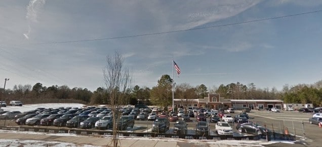
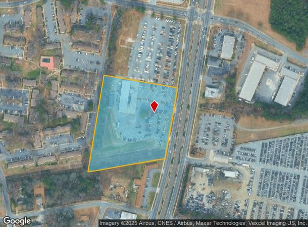
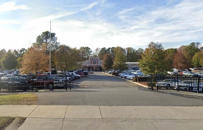

This Property Is For Sale
NEARBY LISTINGS FOR SALE OR LEASE
Property Detail
6027 N Tryon St
Charlotte-Concord-Gastonia, NC-SC
Idlewild
089-231-01
M63-780
Commercialnec
Mecklenburg
X
North Carolina
3710457500L
1
2024
5.78 AC
2025
Northeast
005308
Charlotte
12,178 SF
DEMOGRAPHICS near 6027 N Tryon St
1 Mile
3 Mile
5 Mile
2024 Total Population
14,421
89,719
254,255
2029 Population
15,583
95,890
270,335
Pop Growth 2024-2029
+ 8.06%
+ 6.88%
+ 6.32%
Average Age
34
36
35
2024 Total Households
5,029
34,830
105,221
HH Growth 2024-2029
+ 8.05%
+ 6.92%
+ 6.47%
Median Household Inc
$40,075
$51,458
$56,346
Avg Household Size
2.70
2.50
2.30
2024 Avg HH Vehicles
2.00
2.00
2.00
Median Home Value
$142,011
$223,833
$259,552
Median Year Built
1984
1988
1992
Nearby Places
Map Layers
Map Styles
 Street
 Aerial
- Restaurants
- Banks
- Shops
- Fitness
- Groceries
PUBLIC TRANSPORTATION
COMMUTER RAIL
DRIVE
WALK
Distance
9 min
4.3 mi
AIRPORT
Concord-Padgett Regional
DRIVE
WALK
Distance
Concord-Padgett Regional
20 min
11.0 mi
Charlotte/Douglas International
DRIVE
WALK
Distance
Charlotte/Douglas International
28 min
13.2 mi
Nearby Properties
Address
Land Use
TOTAL SIZE
Lot Size
Zoning
Address
Land Use
TOTAL SIZE
Lot Size
Zoning
2,534,387 SF
135.23 AC
RE2
Address
Land Use
TOTAL SIZE
Lot Size
Zoning
2,215,042 SF
68.45 AC
RE2
Address
Land Use
TOTAL SIZE
Lot Size
Zoning
628,300 SF
197.32 AC
INST
Address
Land Use
TOTAL SIZE
Lot Size
Zoning
690,862 SF
136.80 AC
R17MF
Address
Land Use
TOTAL SIZE
Lot Size
Zoning
419,364 SF
17.40 AC
Address
Land Use
TOTAL SIZE
Lot Size
Zoning
285,032 SF
9.43 AC
UR2CD
Address
Land Use
TOTAL SIZE
Lot Size
Zoning
500,761 SF
3.18 AC
TOD-CC
Address
Land Use
TOTAL SIZE
Lot Size
Zoning
333,683 SF
24.11 AC
RE2
Address
Land Use
TOTAL SIZE
Lot Size
Zoning
499,296 SF
6.04 AC
Address
Land Use
TOTAL SIZE
Lot Size
Zoning
389,680 SF
28.83 AC
R17MFCD
Address
Land Use
TOTAL SIZE
Lot Size
Zoning
324,898 SF
22.31 AC
R17MFCD
Address
Land Use
TOTAL SIZE
Lot Size
Zoning
215,899 SF
4.86 AC
B-2(CD)
Address
Land Use
TOTAL SIZE
Lot Size
Zoning
436,898 SF
3.20 AC
Address
Land Use
TOTAL SIZE
Lot Size
Zoning
335,688 SF
22.54 AC
Address
Land Use
TOTAL SIZE
Lot Size
Zoning
322,996 SF
10.45 AC
I2
Address
Land Use
TOTAL SIZE
Lot Size
Zoning
358,524 SF
23.80 AC
R17MFCD
Address
Land Use
TOTAL SIZE
Lot Size
Zoning
464,520 SF
3.43 AC
Address
Land Use
TOTAL SIZE
Lot Size
Zoning
325,799 SF
37.65 AC
R9MFCD
Address
Land Use
TOTAL SIZE
Lot Size
Zoning
19.62 AC
Address
Land Use
TOTAL SIZE
Lot Size
Zoning
352,085 SF
23.50 AC
NS
Address
Land Use
TOTAL SIZE
Lot Size
Zoning
276,596 SF
41.26 AC
Address
Land Use
TOTAL SIZE
Lot Size
Zoning
311,358 SF
8.95 AC
B2
Address
Land Use
TOTAL SIZE
Lot Size
Zoning
68,352 SF
3.83 AC
TOD-M(O)
Address
Land Use
TOTAL SIZE
Lot Size
Zoning
205,022 SF
15.68 AC
R9MFCD
Address
Land Use
TOTAL SIZE
Lot Size
Zoning
322,390 SF
7.05 AC
O-15(CD)
Address
Land Use
TOTAL SIZE
Lot Size
Zoning
441,665 SF
3.24 AC
MUDDO
Address
Land Use
TOTAL SIZE
Lot Size
Zoning
432,086 SF
2.92 AC
TOD-CC
Address
Land Use
TOTAL SIZE
Lot Size
Zoning
261,810 SF
46.15 AC
R3
Address
Land Use
TOTAL SIZE
Lot Size
Zoning
40,940 SF
3.53 AC
TOD-UC
Address
Land Use
TOTAL SIZE
Lot Size
Zoning
5.60 AC
MUDD(CD)
The World's #1 Commercial Real Estate Marketplace
Connect with us
© 2025 CoStar Group
The information above has been obtained from sources believed reliable. While we do not doubt its accuracy we have not verified it and make no guarantee, warranty or representation about it. It is your responsibility to independently confirm its accuracy and completeness. Any projections, opinions, assumptions, or estimates used are for example only and do not represent the current or future performance of the property. The value of this transaction to you depends on tax and other factors which should be evaluated by your tax, financial, and legal advisors. You and your advisors should conduct a careful, independent investigation of the property to determine to your satisfaction the suitability of the property for your needs.