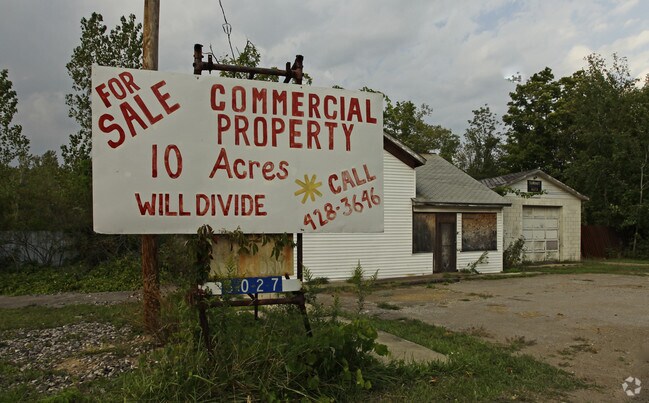
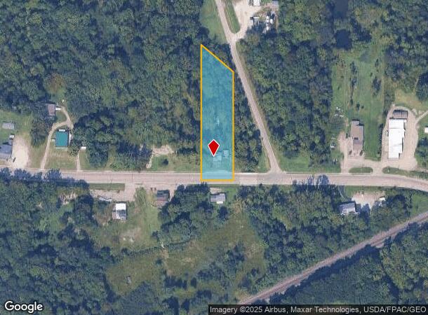
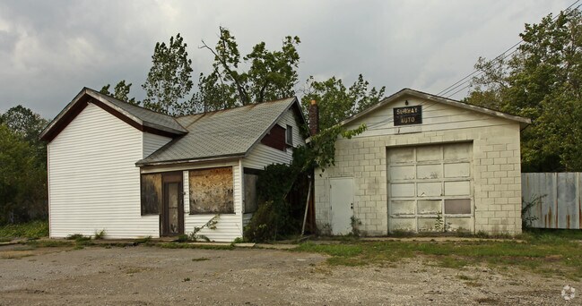
Property Record
6027 N Ridge Rd W, Ashtabula, OH 44004
NEARBY LISTINGS FOR SALE OR LEASE
Property Detail
6027 N Ridge Rd W
170070002100
SEC 3--3 W M OF E 1/2
Commercialnec
Ashtabula
X
Ohio
39007C0140D
1.48 AC
2024
Ashtabula County
2024
Cleveland
000702
Ashtabula, OH
896 SF
DEMOGRAPHICS near 6027 N Ridge Rd W
1 Mile
3 Mile
5 Mile
2024 Total Population
1,308
9,954
23,676
2029 Population
1,287
9,836
23,648
Pop Growth 2024-2029
(1.61%)
(1.19%)
(0.12%)
Average Age
44
43
43
2024 Total Households
533
4,139
9,882
HH Growth 2024-2029
(2.06%)
(1.33%)
(0.15%)
Median Household Inc
$36,875
$48,418
$53,236
Avg Household Size
2.30
2.30
2.30
2024 Avg HH Vehicles
2.00
2.00
2.00
Median Home Value
$176,767
$148,405
$154,536
Median Year Built
1953
1963
1969
Nearby Places
Map Layers
Map Styles
 Street
 Aerial
- Restaurants
- Banks
- Shops
- Fitness
- Groceries
SALE & LEASE HISTORY
LISTING DATE
SALE/LEASE

Sep 24, 2016
For Sale
Nearby Properties
Address
Land Use
TOTAL SIZE
Lot Size
Zoning
Address
Land Use
TOTAL SIZE
Lot Size
Zoning
Address
Land Use
TOTAL SIZE
Lot Size
Zoning
154,188 SF
71.54 AC
Address
Land Use
TOTAL SIZE
Lot Size
Zoning
84,225 SF
7.46 AC
Address
Land Use
TOTAL SIZE
Lot Size
Zoning
57,030 SF
15.32 AC
Address
Land Use
TOTAL SIZE
Lot Size
Zoning
788,518 SF
141.13 AC
Address
Land Use
TOTAL SIZE
Lot Size
Zoning
Address
Land Use
TOTAL SIZE
Lot Size
Zoning
31,689 SF
41.05 AC
R5
Address
Land Use
TOTAL SIZE
Lot Size
Zoning
75,286 SF
4.10 AC
Address
Land Use
TOTAL SIZE
Lot Size
Zoning
215,590 SF
15.22 AC
Address
Land Use
TOTAL SIZE
Lot Size
Zoning
42,679 SF
7.22 AC
Address
Land Use
TOTAL SIZE
Lot Size
Zoning
5,095 SF
239.16 AC
A-1
Address
Land Use
TOTAL SIZE
Lot Size
Zoning
Address
Land Use
TOTAL SIZE
Lot Size
Zoning
43,785 SF
9.84 AC
R4
Address
Land Use
TOTAL SIZE
Lot Size
Zoning
17,408 SF
7.47 AC
Address
Land Use
TOTAL SIZE
Lot Size
Zoning
151,259 SF
5.95 AC
Address
Land Use
TOTAL SIZE
Lot Size
Zoning
Address
Land Use
TOTAL SIZE
Lot Size
Zoning
80,000 SF
10.16 AC
Address
Land Use
TOTAL SIZE
Lot Size
Zoning
50,470 SF
1.29 AC
R1
Address
Land Use
TOTAL SIZE
Lot Size
Zoning
30,548 SF
2.56 AC
Address
Land Use
TOTAL SIZE
Lot Size
Zoning
24,658 SF
2.22 AC
Address
Land Use
TOTAL SIZE
Lot Size
Zoning
76,728 SF
6.52 AC
Address
Land Use
TOTAL SIZE
Lot Size
Zoning
16,422 SF
3 AC
Address
Land Use
TOTAL SIZE
Lot Size
Zoning
18,984 SF
9.33 AC
Address
Land Use
TOTAL SIZE
Lot Size
Zoning
87,460 SF
2.39 AC
Address
Land Use
TOTAL SIZE
Lot Size
Zoning
Address
Land Use
TOTAL SIZE
Lot Size
Zoning
51,086 SF
2.54 AC
Address
Land Use
TOTAL SIZE
Lot Size
Zoning
Address
Land Use
TOTAL SIZE
Lot Size
Zoning
Address
Land Use
TOTAL SIZE
Lot Size
Zoning
63,120 SF
2.79 AC
M1
Address
Land Use
TOTAL SIZE
Lot Size
Zoning
21,343 SF
1.94 AC
The World's #1 Commercial Real Estate Marketplace
Connect with us
© 2025 CoStar Group
The information above has been obtained from sources believed reliable. While we do not doubt its accuracy we have not verified it and make no guarantee, warranty or representation about it. It is your responsibility to independently confirm its accuracy and completeness. Any projections, opinions, assumptions, or estimates used are for example only and do not represent the current or future performance of the property. The value of this transaction to you depends on tax and other factors which should be evaluated by your tax, financial, and legal advisors. You and your advisors should conduct a careful, independent investigation of the property to determine to your satisfaction the suitability of the property for your needs.