Property Record
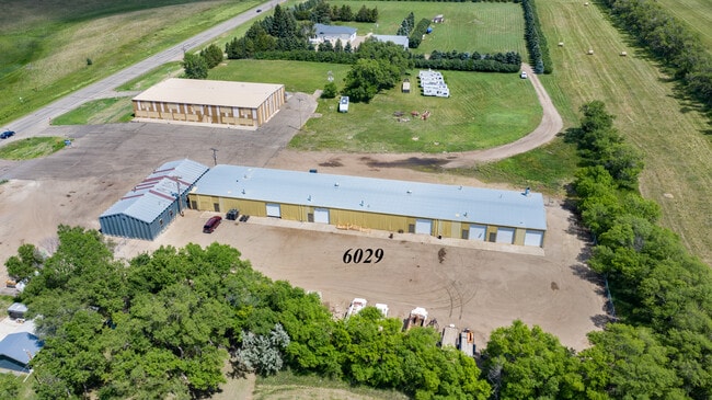
6029 E Main Ave, Bismarck, ND 58501


Property Detail
6029 E Main Ave
0113-006-050
CITY LANDS 138-79 PART NE1/4 BEG PT 1824.53' W & 100' S OF NE COR TH W 235.49' S 469.80' E 235.49' N 469.80' (AKA LOT D)
Lightindustrial
BURLEIGH
MA
North Dakota
B and X Area of moderate flood hazard, usually the area between the limits of the 100-year and 500-year floods.
d
2025
2.54 AC
2025
East Bismarck
010300
Other Market Areas
12,600 SF
Bismarck, ND
NEARBY LISTINGS FOR SALE OR LEASE
DEMOGRAPHICS near 6029 E Main Ave
1 mile
3 mile
5 mile
2025 Total Population
954
16,147
61,724
2030 Population
1,010
16,755
63,678
Pop Growth 2025-2030
+ 5.87%
+ 3.77%
+ 3.17%
Average Age
38
39
41
2025 Total Households
299
5,917
26,397
HH Growth 2025-2030
+ 6.35%
+ 3.87%
+ 3.54%
Median Household Inc
$138,194
$98,590
$78,516
Avg Household Size
2.70
2.40
2.20
2025 Avg HH Vehicles
2.00
2.00
2.00
Median Home Value
$447,747
$310,331
$274,202
Median Year Built
2001
1996
1980
Nearby Places
Map Layers
Map Styles
 Street
 Aerial
Layers
 Traffic
 Biking
Places
Listings with unknown addresses are not visible on the map
- Restaurants
- Banks
- Shops
- Fitness
- Groceries
PUBLIC TRANSPORTATION
AIRPORT
Bismarck Municipal
Drive
Walk
Distance
Bismarck Municipal
15 min
5.1 mi
Freight Ports
Port Milwaukee
Drive
Walk
Distance
Port Milwaukee
822 min
764.5 mi
SALE & LEASE HISTORY
LISTING DATE
SALE/LEASE

Aug 04, 2020
For Sale
Nearby Properties
Address
Land Use
TOTAL SIZE
Lot Size
Zoning
Address
Land Use
TOTAL SIZE
Lot Size
Zoning
26.42 AC
MA
Address
Land Use
TOTAL SIZE
Lot Size
Zoning
30.33 AC
MA
Address
Land Use
TOTAL SIZE
Lot Size
Zoning
35.42 AC
MA
Address
Land Use
TOTAL SIZE
Lot Size
Zoning
20.41 AC
MA
Address
Land Use
TOTAL SIZE
Lot Size
Zoning
14.22 AC
MA
Address
Land Use
TOTAL SIZE
Lot Size
Zoning
84,342 SF
11.63 AC
MA
Address
Land Use
TOTAL SIZE
Lot Size
Zoning
42,908 SF
12.44 AC
MA
Address
Land Use
TOTAL SIZE
Lot Size
Zoning
42,908 SF
12.14 AC
MA
Address
Land Use
TOTAL SIZE
Lot Size
Zoning
7,288 SF
7.50 AC
CG
Address
Land Use
TOTAL SIZE
Lot Size
Zoning
64,008 SF
12.61 AC
MA
Address
Land Use
TOTAL SIZE
Lot Size
Zoning
79,200 SF
6.01 AC
MA
Address
Land Use
TOTAL SIZE
Lot Size
Zoning
8.16 AC
MA
Address
Land Use
TOTAL SIZE
Lot Size
Zoning
7.65 AC
MA
Address
Land Use
TOTAL SIZE
Lot Size
Zoning
63,247 SF
6.80 AC
MA
Address
Land Use
TOTAL SIZE
Lot Size
Zoning
25,336 SF
3.22 AC
RM15
Address
Land Use
TOTAL SIZE
Lot Size
Zoning
16,005 SF
5.46 AC
MA
Address
Land Use
TOTAL SIZE
Lot Size
Zoning
36,400 SF
5.10 AC
CG
Address
Land Use
TOTAL SIZE
Lot Size
Zoning
56,846 SF
8.26 AC
MA
Address
Land Use
TOTAL SIZE
Lot Size
Zoning
53,393 SF
6.60 AC
CG
Address
Land Use
TOTAL SIZE
Lot Size
Zoning
92,929 SF
5.41 AC
MA
Address
Land Use
TOTAL SIZE
Lot Size
Zoning
40.68 AC
RMH
Address
Land Use
TOTAL SIZE
Lot Size
Zoning
42,743 SF
5.24 AC
MA
Address
Land Use
TOTAL SIZE
Lot Size
Zoning
4.36 AC
MA
Address
Land Use
TOTAL SIZE
Lot Size
Zoning
44,428 SF
2.94 AC
MA
Address
Land Use
TOTAL SIZE
Lot Size
Zoning
35.79 AC
RMH
Address
Land Use
TOTAL SIZE
Lot Size
Zoning
72,975 SF
5.97 AC
MA
Address
Land Use
TOTAL SIZE
Lot Size
Zoning
42,200 SF
4 AC
MA
Address
Land Use
TOTAL SIZE
Lot Size
Zoning
22,848 SF
8.70 AC
MA
Address
Land Use
TOTAL SIZE
Lot Size
Zoning
Address
Land Use
TOTAL SIZE
Lot Size
Zoning
23,637 SF
4.76 AC
MA
The World's #1 Commercial Real Estate Marketplace
Connect with us
© 2026 CoStar Group
The information above has been obtained from sources believed reliable. While we do not doubt its accuracy we have not verified it and make no guarantee, warranty or representation about it. It is your responsibility to independently confirm its accuracy and completeness. Any projections, opinions, assumptions, or estimates used are for example only and do not represent the current or future performance of the property. The value of this transaction to you depends on tax and other factors which should be evaluated by your tax, financial, and legal advisors. You and your advisors should conduct a careful, independent investigation of the property to determine to your satisfaction the suitability of the property for your needs.