Property Record
603 E 2Nd St, Ogallala, NE 69153
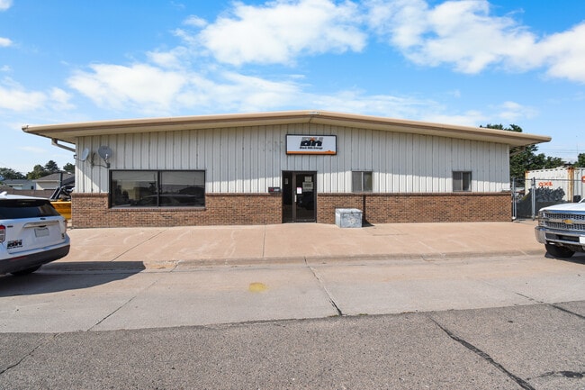

This Property Is For Sale
Property Detail
603 E 2Nd St
000103900
LOTS 5 & 6 BLK 14 ORIGINAL TOWN 1----16
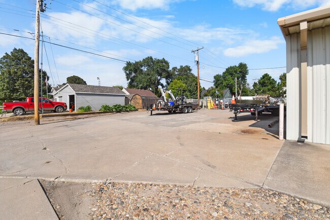
Autorepair
KEITH
03-COMMERC
Nebraska
B and X Area of moderate flood hazard, usually the area between the limits of the 100-year and 500-year floods.
5,6
0
0.38 AC
2025
I-80 Corridor
000200
Other Market Areas
4,800 SF
NEARBY LISTINGS FOR SALE OR LEASE
-
-
View all Ogallala listings for sale on LoopNet.com
DEMOGRAPHICS near 603 E 2Nd St
1 mile
3 mile
5 mile
2025 Total Population
3,444
4,833
5,000
2030 Population
3,351
4,690
4,854
Pop Growth 2025-2030
(2.70%)
(2.96%)
(2.92%)
Average Age
42
42
42
2025 Total Households
1,508
2,071
2,142
HH Growth 2025-2030
(2.98%)
(3.24%)
(3.17%)
Median Household Inc
$53,707
$56,753
$57,070
Avg Household Size
2.20
2.30
2.30
2025 Avg HH Vehicles
2.00
2.00
2.00
Median Home Value
$140,448
$153,775
$155,882
Median Year Built
1961
1968
1968
Nearby Places
Map Layers
Map Styles
 Street
 Aerial
Transit
 Traffic
 Biking
Places
Listings with unknown addresses are not visible on the map
- Restaurants
- Banks
- Shops
- Fitness
- Groceries
Nearby Properties
Address
Land Use
TOTAL SIZE
Lot Size
Zoning
Address
Land Use
TOTAL SIZE
Lot Size
Zoning
74,842 SF
10 AC
01-SINGLE
Address
Land Use
TOTAL SIZE
Lot Size
Zoning
42,408 SF
1.86 AC
03-COMMERC
Address
Land Use
TOTAL SIZE
Lot Size
Zoning
51,912 SF
2.23 AC
03-COMMERC
Address
Land Use
TOTAL SIZE
Lot Size
Zoning
60,592 SF
20.01 AC
07-OTHER
Address
Land Use
TOTAL SIZE
Lot Size
Zoning
69,866 SF
8.66 AC
03-COMMERC
Address
Land Use
TOTAL SIZE
Lot Size
Zoning
10,981 SF
111.75 AC
07-OTHER
Address
Land Use
TOTAL SIZE
Lot Size
Zoning
25,806 SF
4.69 AC
03-COMMERC
Address
Land Use
TOTAL SIZE
Lot Size
Zoning
21,552 SF
1.12 AC
03-COMMERC
Address
Land Use
TOTAL SIZE
Lot Size
Zoning
67,183 SF
3.32 AC
01-SINGLE
Address
Land Use
TOTAL SIZE
Lot Size
Zoning
13,145 SF
1.90 AC
02-MULTI-F
Address
Land Use
TOTAL SIZE
Lot Size
Zoning
34,974 SF
8.76 AC
03-COMMERC
Address
Land Use
TOTAL SIZE
Lot Size
Zoning
3,060 SF
3.03 AC
02-MULTI-F
Address
Land Use
TOTAL SIZE
Lot Size
Zoning
34,026 SF
1.70 AC
03-COMMERC
Address
Land Use
TOTAL SIZE
Lot Size
Zoning
42,540 SF
4.31 AC
03-COMMERC
Address
Land Use
TOTAL SIZE
Lot Size
Zoning
8,653 SF
11.34 AC
01-SINGLE
Address
Land Use
TOTAL SIZE
Lot Size
Zoning
12,384 SF
2.23 AC
03-COMMERC
Address
Land Use
TOTAL SIZE
Lot Size
Zoning
23,500 SF
13.08 AC
03-COMMERC
Address
Land Use
TOTAL SIZE
Lot Size
Zoning
14,928 SF
3.67 AC
03-COMMERC
Address
Land Use
TOTAL SIZE
Lot Size
Zoning
9,860 SF
2 AC
01-SINGLE
Address
Land Use
TOTAL SIZE
Lot Size
Zoning
10,100 SF
1.44 AC
02-MULTI-F
Address
Land Use
TOTAL SIZE
Lot Size
Zoning
15,236 SF
9.20 AC
03-COMMERC
Address
Land Use
TOTAL SIZE
Lot Size
Zoning
23,016 SF
1.60 AC
03-COMMERC
Address
Land Use
TOTAL SIZE
Lot Size
Zoning
61,985 SF
3.24 AC
04-INDUSTR
Address
Land Use
TOTAL SIZE
Lot Size
Zoning
11,275 SF
0.58 AC
03-COMMERC
Address
Land Use
TOTAL SIZE
Lot Size
Zoning
15,000 SF
4.54 AC
03-COMMERC
Address
Land Use
TOTAL SIZE
Lot Size
Zoning
5.70 AC
03-COMMERC
Address
Land Use
TOTAL SIZE
Lot Size
Zoning
8,707 SF
1.11 AC
03-COMMERC
Address
Land Use
TOTAL SIZE
Lot Size
Zoning
9,454 SF
1.60 AC
03-COMMERC
Address
Land Use
TOTAL SIZE
Lot Size
Zoning
18,600 SF
2.76 AC
03-COMMERC
The World's #1 Commercial Real Estate Marketplace
Connect with us
© 2026 CoStar Group
The information above has been obtained from sources believed reliable. While we do not doubt its accuracy we have not verified it and make no guarantee, warranty or representation about it. It is your responsibility to independently confirm its accuracy and completeness. Any projections, opinions, assumptions, or estimates used are for example only and do not represent the current or future performance of the property. The value of this transaction to you depends on tax and other factors which should be evaluated by your tax, financial, and legal advisors. You and your advisors should conduct a careful, independent investigation of the property to determine to your satisfaction the suitability of the property for your needs.