Property Record
603 Main St, Wilmington, MA 01887
NEARBY LISTINGS FOR SALE OR LEASE
Property Detail
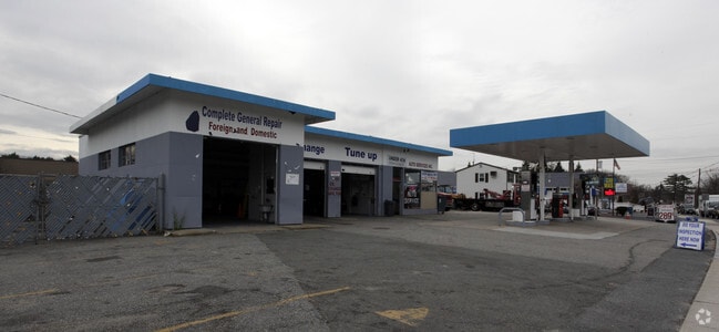
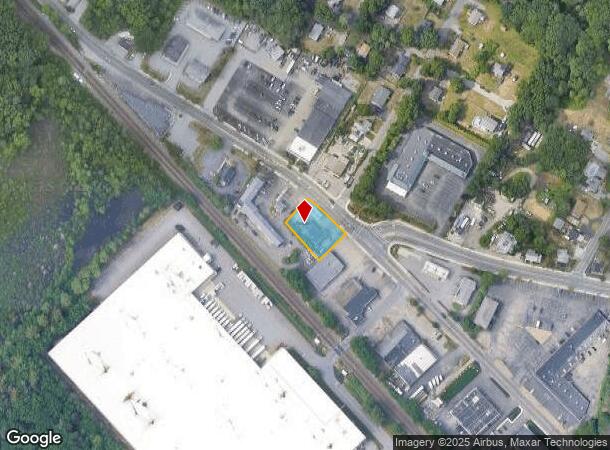
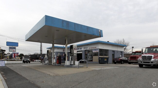
603 Main St
Servicestation
Middlesex
X
Massachusetts
25017C0291F
0.33 AC
2025
Wilmington/Reading
2025
Boston
331102
Boston-Cambridge-Newton, MA-NH
2,134 SF
WILM-000041-000000-000000-000138A
DEMOGRAPHICS near 603 Main St
1 Mile
3 Mile
5 Mile
2024 Total Population
4,711
56,271
162,075
2029 Population
4,656
55,679
160,746
Pop Growth 2024-2029
(1.17%)
(1.05%)
(0.82%)
Average Age
42
41
42
2024 Total Households
1,627
20,094
60,923
HH Growth 2024-2029
(1.29%)
(1.08%)
(0.85%)
Median Household Inc
$153,519
$137,158
$122,363
Avg Household Size
2.90
2.70
2.60
2024 Avg HH Vehicles
2.00
2.00
2.00
Median Home Value
$658,111
$671,392
$652,851
Median Year Built
1969
1974
1970
Nearby Places
Map Layers
Map Styles
 Street
 Aerial
- Restaurants
- Banks
- Shops
- Fitness
- Groceries
PUBLIC TRANSPORTATION
COMMUTER RAIL
Wilmington (Lowell Line - Massachusetts Bay Transportation Authority Commuter Rail (Purple Line))
DRIVE
WALK
Distance
Wilmington (Lowell Line - Massachusetts Bay Transportation Authority Commuter Rail (Purple Line))
1 min
9 min
0.4 mi
North Wilmington (Haverhill Line - Massachusetts Bay Transportation Authority Commuter Rail (Purple Line))
DRIVE
WALK
Distance
North Wilmington (Haverhill Line - Massachusetts Bay Transportation Authority Commuter Rail (Purple Line))
4 min
2.2 mi
AIRPORT
General Edward Lawrence Logan International
DRIVE
WALK
Distance
General Edward Lawrence Logan International
26 min
18.0 mi
Freight Ports
Port of Boston
DRIVE
WALK
Distance
Port of Boston
27 min
17.7 mi
Nearby Properties
Address
Land Use
TOTAL SIZE
Lot Size
Zoning
Address
Land Use
TOTAL SIZE
Lot Size
Zoning
42.20 AC
S-2
Address
Land Use
TOTAL SIZE
Lot Size
Zoning
196,098 SF
22.41 AC
R20
Address
Land Use
TOTAL SIZE
Lot Size
Zoning
27.56 AC
R-2
Address
Land Use
TOTAL SIZE
Lot Size
Zoning
405,606 SF
33.40 AC
RO
Address
Land Use
TOTAL SIZE
Lot Size
Zoning
18.62 AC
O-P
Address
Land Use
TOTAL SIZE
Lot Size
Zoning
411,956 SF
23.94 AC
S20
Address
Land Use
TOTAL SIZE
Lot Size
Zoning
30.92 AC
RO
Address
Land Use
TOTAL SIZE
Lot Size
Zoning
275,751 SF
41.30 AC
R20
Address
Land Use
TOTAL SIZE
Lot Size
Zoning
272,632 SF
22.49 AC
IND
Address
Land Use
TOTAL SIZE
Lot Size
Zoning
368,748 SF
40.10 AC
IND
Address
Land Use
TOTAL SIZE
Lot Size
Zoning
110,162 SF
16.67 AC
5
Address
Land Use
TOTAL SIZE
Lot Size
Zoning
341,593 SF
3.38 AC
I-P2
Address
Land Use
TOTAL SIZE
Lot Size
Zoning
129,028 SF
7.17 AC
I-P2
Address
Land Use
TOTAL SIZE
Lot Size
Zoning
27.90 AC
I-P2
Address
Land Use
TOTAL SIZE
Lot Size
Zoning
398,140 SF
39.50 AC
GI
Address
Land Use
TOTAL SIZE
Lot Size
Zoning
10.73 AC
I-P2
Address
Land Use
TOTAL SIZE
Lot Size
Zoning
141,968 SF
11.28 AC
R20
Address
Land Use
TOTAL SIZE
Lot Size
Zoning
6.77 AC
I-P2
Address
Land Use
TOTAL SIZE
Lot Size
Zoning
91.75 AC
3
Address
Land Use
TOTAL SIZE
Lot Size
Zoning
481,812 SF
25.97 AC
I-P2
Address
Land Use
TOTAL SIZE
Lot Size
Zoning
264,976 SF
34.74 AC
Address
Land Use
TOTAL SIZE
Lot Size
Zoning
17,480 SF
8.23 AC
R-2
Address
Land Use
TOTAL SIZE
Lot Size
Zoning
161,736 SF
13.91 AC
Address
Land Use
TOTAL SIZE
Lot Size
Zoning
145,745 SF
11.54 AC
GI
Address
Land Use
TOTAL SIZE
Lot Size
Zoning
5.91 AC
I-P2
Address
Land Use
TOTAL SIZE
Lot Size
Zoning
175,682 SF
20.80 AC
IB
Address
Land Use
TOTAL SIZE
Lot Size
Zoning
161,424 SF
26 AC
RO
Address
Land Use
TOTAL SIZE
Lot Size
Zoning
329,496 SF
16.16 AC
G-B
Address
Land Use
TOTAL SIZE
Lot Size
Zoning
74,425 SF
14.60 AC
RO
Address
Land Use
TOTAL SIZE
Lot Size
Zoning
127,016 SF
11.01 AC
IB
The World's #1 Commercial Real Estate Marketplace
Connect with us
© 2025 CoStar Group
The information above has been obtained from sources believed reliable. While we do not doubt its accuracy we have not verified it and make no guarantee, warranty or representation about it. It is your responsibility to independently confirm its accuracy and completeness. Any projections, opinions, assumptions, or estimates used are for example only and do not represent the current or future performance of the property. The value of this transaction to you depends on tax and other factors which should be evaluated by your tax, financial, and legal advisors. You and your advisors should conduct a careful, independent investigation of the property to determine to your satisfaction the suitability of the property for your needs.