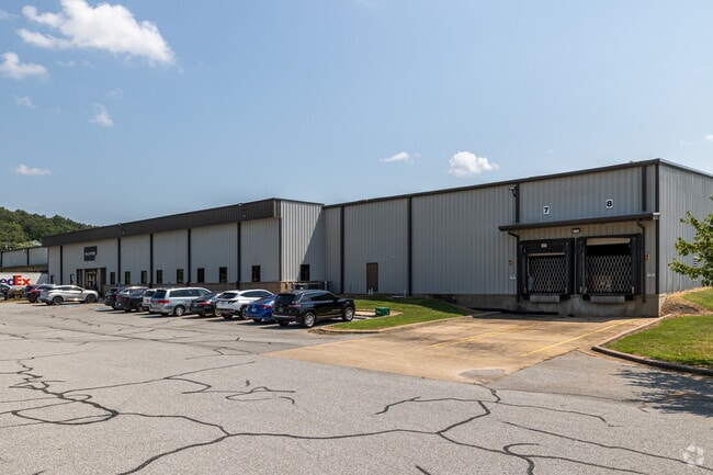
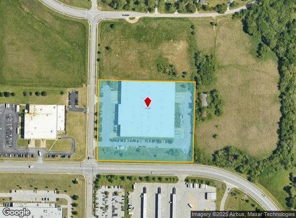
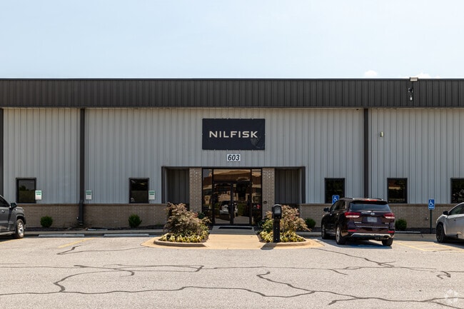
Property Record
603 N Monitor Rd, Springdale, AR 72764
Current Lease Availabilities
NEARBY LISTINGS FOR SALE OR LEASE
Property Detail
603 N Monitor Rd
Fayetteville-Springdale-Rogers, AR-MO
R L Hayes S/D
815-22518-050
LOT 27-C PER REPLAT OF LOT 27-A R. L. HAYES S/D 24A-65 7.73 AC FURTHER DESCRIBED FROM 2015-13105 AS: A PART OF THE SOUTHWEST
Commercialnec
Washington
X
Arkansas
05143C0080G
27
2025
7.73 AC
2025
Greater Springdale
010101
Fayetteville/Springdale/Rogers
130,323 SF
DEMOGRAPHICS near 603 N Monitor Rd
1 Mile
3 Mile
5 Mile
2024 Total Population
6,538
53,564
98,510
2029 Population
7,188
59,013
108,887
Pop Growth 2024-2029
+ 9.94%
+ 10.17%
+ 10.53%
Average Age
29
33
35
2024 Total Households
1,794
15,909
32,163
HH Growth 2024-2029
+ 10.09%
+ 10.30%
+ 10.71%
Median Household Inc
$52,251
$56,111
$63,866
Avg Household Size
3.50
3.20
2.90
2024 Avg HH Vehicles
2.00
2.00
2.00
Median Home Value
$162,594
$184,033
$208,030
Median Year Built
1998
1993
1993
Nearby Places
- Restaurants
- Banks
- Shops
- Fitness
- Groceries
PUBLIC TRANSPORTATION
AIRPORT
Northwest Arkansas Ntl
DRIVE
WALK
Distance
Northwest Arkansas Ntl
37 min
18.7 mi
Freight Ports
Tulsa Port of Inola
DRIVE
WALK
Distance
Tulsa Port of Inola
108 min
89.7 mi
Nearby Properties
Address
Land Use
TOTAL SIZE
Lot Size
Zoning
Address
Land Use
TOTAL SIZE
Lot Size
Zoning
58,764 SF
1.56 AC
Address
Land Use
TOTAL SIZE
Lot Size
Zoning
403,089 SF
1.93 AC
Address
Land Use
TOTAL SIZE
Lot Size
Zoning
481,800 SF
40 AC
Address
Land Use
TOTAL SIZE
Lot Size
Zoning
153,718 SF
Address
Land Use
TOTAL SIZE
Lot Size
Zoning
341,266 SF
17.61 AC
Address
Land Use
TOTAL SIZE
Lot Size
Zoning
4,941 SF
10.87 AC
Address
Land Use
TOTAL SIZE
Lot Size
Zoning
174,333 SF
25 AC
I1I2
Address
Land Use
TOTAL SIZE
Lot Size
Zoning
156,072 SF
12.43 AC
Address
Land Use
TOTAL SIZE
Lot Size
Zoning
16,698 SF
1.11 AC
Address
Land Use
TOTAL SIZE
Lot Size
Zoning
178,140 SF
4.39 AC
Address
Land Use
TOTAL SIZE
Lot Size
Zoning
180,412 SF
13.14 AC
Address
Land Use
TOTAL SIZE
Lot Size
Zoning
117,196 SF
9.74 AC
Address
Land Use
TOTAL SIZE
Lot Size
Zoning
224,408 SF
9.80 AC
I1
Address
Land Use
TOTAL SIZE
Lot Size
Zoning
73,436 SF
16.01 AC
I1
Address
Land Use
TOTAL SIZE
Lot Size
Zoning
206,446 SF
17.14 AC
Address
Land Use
TOTAL SIZE
Lot Size
Zoning
116,736 SF
10.95 AC
Address
Land Use
TOTAL SIZE
Lot Size
Zoning
80,475 SF
0.45 AC
C3
Address
Land Use
TOTAL SIZE
Lot Size
Zoning
147,762 SF
Address
Land Use
TOTAL SIZE
Lot Size
Zoning
74,434 SF
32.25 AC
Address
Land Use
TOTAL SIZE
Lot Size
Zoning
352,195 SF
15 AC
Address
Land Use
TOTAL SIZE
Lot Size
Zoning
107,950 SF
6.68 AC
C2
Address
Land Use
TOTAL SIZE
Lot Size
Zoning
54,460 SF
6.38 AC
Address
Land Use
TOTAL SIZE
Lot Size
Zoning
153,968 SF
21 AC
Address
Land Use
TOTAL SIZE
Lot Size
Zoning
364,696 SF
4.49 AC
Address
Land Use
TOTAL SIZE
Lot Size
Zoning
189,244 SF
11.16 AC
I2
Address
Land Use
TOTAL SIZE
Lot Size
Zoning
38,594 SF
6.04 AC
Address
Land Use
TOTAL SIZE
Lot Size
Zoning
55,663 SF
2.54 AC
Address
Land Use
TOTAL SIZE
Lot Size
Zoning
162,000 SF
16 AC
I2
Address
Land Use
TOTAL SIZE
Lot Size
Zoning
81,121 SF
10.99 AC
Address
Land Use
TOTAL SIZE
Lot Size
Zoning
38,058 SF
9.13 AC
The World's #1 Commercial Real Estate Marketplace
Connect with us
© 2025 CoStar Group
The information above has been obtained from sources believed reliable. While we do not doubt its accuracy we have not verified it and make no guarantee, warranty or representation about it. It is your responsibility to independently confirm its accuracy and completeness. Any projections, opinions, assumptions, or estimates used are for example only and do not represent the current or future performance of the property. The value of this transaction to you depends on tax and other factors which should be evaluated by your tax, financial, and legal advisors. You and your advisors should conduct a careful, independent investigation of the property to determine to your satisfaction the suitability of the property for your needs.