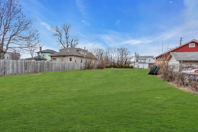
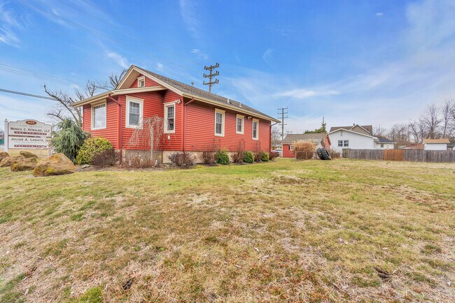
Property Record
603 State Route 35 S, Neptune, NJ 07753

Property Detail
603 State Route 35 S
35-00807-0000-00010
MONMOUTH
Vacantlandnec
New Jersey
B-1
10
B and X Area of moderate flood hazard, usually the area between the limits of the 100-year and 500-year floods.
0.15 AC
2024
Southern Monmouth
2025
Northern New Jersey
807800
Lakewood-New Brunswick, NJ
NEARBY LISTINGS FOR SALE OR LEASE
-
-
-
No Photo
-
-
-
View all Neptune listings for sale on LoopNet.com
DEMOGRAPHICS near 603 State Route 35 S
1 mile
3 mile
5 mile
2025 Total Population
16,295
85,453
148,216
2030 Population
16,269
86,861
150,850
Pop Growth 2025-2030
(0.16%)
+ 1.65%
+ 1.78%
Average Age
38
44
43
2025 Total Households
5,932
37,528
62,458
HH Growth 2025-2030
(0.40%)
+ 1.66%
+ 1.71%
Median Household Inc
$70,792
$97,785
$103,155
Avg Household Size
2.60
2.20
2.30
2025 Avg HH Vehicles
2.00
2.00
2.00
Median Home Value
$471,893
$646,598
$675,388
Median Year Built
1958
1965
1968
Nearby Places
Map Layers
Map Styles
 Street
 Aerial
Layers
 Traffic
 Biking
Places
Listings with unknown addresses are not visible on the map
- Restaurants
- Banks
- Shops
- Fitness
- Groceries
PUBLIC TRANSPORTATION
COMMUTER RAIL
Asbury Park (North Jersey Coast Line - NJ Transit Commuter Rail (NJ Transit))
Drive
Walk
Distance
Asbury Park (North Jersey Coast Line - NJ Transit Commuter Rail (NJ Transit))
4 min
1.5 mi
Bradley Beach (North Jersey Coast Line - NJ Transit Commuter Rail (NJ Transit))
Drive
Walk
Distance
Bradley Beach (North Jersey Coast Line - NJ Transit Commuter Rail (NJ Transit))
3 min
1.7 mi
AIRPORT
Newark Liberty International
Drive
Walk
Distance
Newark Liberty International
60 min
49.5 mi
Freight Ports
New York Container Terminal
Drive
Walk
Distance
New York Container Terminal
54 min
41.5 mi
SALE & LEASE HISTORY
LISTING DATE
SALE/LEASE

Apr 30, 2025
For Sale
Nearby Properties
Address
Land Use
TOTAL SIZE
Lot Size
Zoning
Address
Land Use
TOTAL SIZE
Lot Size
Zoning
26,282 SF
4.59 AC
MU0
Address
Land Use
TOTAL SIZE
Lot Size
Zoning
69,825 SF
94.37 AC
CCRC
Address
Land Use
TOTAL SIZE
Lot Size
Zoning
5,776 SF
25.50 AC
PB
Address
Land Use
TOTAL SIZE
Lot Size
Zoning
739,651 SF
27.89 AC
C
Address
Land Use
TOTAL SIZE
Lot Size
Zoning
113.60 AC
WBA
Address
Land Use
TOTAL SIZE
Lot Size
Zoning
14,632 SF
111.60 AC
C50
Address
Land Use
TOTAL SIZE
Lot Size
Zoning
35.50 AC
MF08
Address
Land Use
TOTAL SIZE
Lot Size
Zoning
320,341 SF
57.85 AC
C
Address
Land Use
TOTAL SIZE
Lot Size
Zoning
1,100 SF
37.83 AC
MF08
Address
Land Use
TOTAL SIZE
Lot Size
Zoning
32.19 AC
MF08
Address
Land Use
TOTAL SIZE
Lot Size
Zoning
25.37 AC
C-1
Address
Land Use
TOTAL SIZE
Lot Size
Zoning
271,456 SF
1.61 AC
SF05
Address
Land Use
TOTAL SIZE
Lot Size
Zoning
279,420 SF
2.01 AC
MU24
Address
Land Use
TOTAL SIZE
Lot Size
Zoning
168,732 SF
2.35 AC
MU24
Address
Land Use
TOTAL SIZE
Lot Size
Zoning
108,641 SF
10.64 AC
C-6
Address
Land Use
TOTAL SIZE
Lot Size
Zoning
181,064 SF
14.62 AC
IL
Address
Land Use
TOTAL SIZE
Lot Size
Zoning
1,288 SF
25.49 AC
HD-R
Address
Land Use
TOTAL SIZE
Lot Size
Zoning
5,228 SF
0.02 AC
C-3
Address
Land Use
TOTAL SIZE
Lot Size
Zoning
1,178 SF
21.78 AC
MF08
Address
Land Use
TOTAL SIZE
Lot Size
Zoning
3,094 SF
277.60 AC
MU0
Address
Land Use
TOTAL SIZE
Lot Size
Zoning
224,683 SF
21.56 AC
CHS
Address
Land Use
TOTAL SIZE
Lot Size
Zoning
91,173 SF
4.07 AC
R3
Address
Land Use
TOTAL SIZE
Lot Size
Zoning
Address
Land Use
TOTAL SIZE
Lot Size
Zoning
183,932 SF
23.51 AC
IL
Address
Land Use
TOTAL SIZE
Lot Size
Zoning
13,200 SF
18.63 AC
C50
Address
Land Use
TOTAL SIZE
Lot Size
Zoning
1,487 SF
7.50 AC
R-B
Address
Land Use
TOTAL SIZE
Lot Size
Zoning
15 AC
MF08
Address
Land Use
TOTAL SIZE
Lot Size
Zoning
133,831 SF
18.38 AC
C50
Address
Land Use
TOTAL SIZE
Lot Size
Zoning
106,096 SF
0.88 AC
C0
Address
Land Use
TOTAL SIZE
Lot Size
Zoning
2,788 SF
1.55 AC
R-1
The World's #1 Commercial Real Estate Marketplace
Connect with us
© 2026 CoStar Group
The information above has been obtained from sources believed reliable. While we do not doubt its accuracy we have not verified it and make no guarantee, warranty or representation about it. It is your responsibility to independently confirm its accuracy and completeness. Any projections, opinions, assumptions, or estimates used are for example only and do not represent the current or future performance of the property. The value of this transaction to you depends on tax and other factors which should be evaluated by your tax, financial, and legal advisors. You and your advisors should conduct a careful, independent investigation of the property to determine to your satisfaction the suitability of the property for your needs.