Property Record
603 Wilson St, Brewer, ME 04412
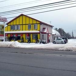

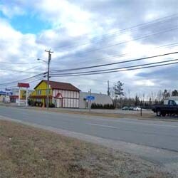
Property Detail
603 Wilson St
BRER-000007-000000-000009
Penobscot
Commercialnec
Maine
GB
9
B and X Area of moderate flood hazard, usually the area between the limits of the 100-year and 500-year floods.
1.11 AC
2025
Maine North & Bangor
2025
Other Market Areas
004200
Bangor, ME
7,480 SF
NEARBY LISTINGS FOR SALE OR LEASE
DEMOGRAPHICS near 603 Wilson St
1 mile
3 mile
5 mile
2025 Total Population
1,230
25,222
46,243
2030 Population
1,223
25,321
47,045
Pop Growth 2025-2030
(0.57%)
+ 0.39%
+ 1.73%
Average Age
47
43
44
2025 Total Households
536
11,698
20,891
HH Growth 2025-2030
(1.31%)
+ 0.36%
+ 1.73%
Median Household Inc
$42,359
$56,718
$64,546
Avg Household Size
2.00
2.00
2.00
2025 Avg HH Vehicles
1.00
1.00
2.00
Median Home Value
$288,311
$253,041
$258,359
Median Year Built
1980
1952
1966
Nearby Places
Map Layers
Map Styles
 Street
 Aerial
Layers
 Traffic
 Biking
Places
Listings with unknown addresses are not visible on the map
- Restaurants
- Banks
- Shops
- Fitness
- Groceries
PUBLIC TRANSPORTATION
AIRPORT
Bangor International
Drive
Walk
Distance
Bangor International
14 min
6.3 mi
Freight Ports
Searsport, ME
Drive
Walk
Distance
Searsport, ME
46 min
31.0 mi
Nearby Properties
Address
Land Use
TOTAL SIZE
Lot Size
Zoning
Address
Land Use
TOTAL SIZE
Lot Size
Zoning
609,180 SF
6.68 AC
USD
Address
Land Use
TOTAL SIZE
Lot Size
Zoning
Address
Land Use
TOTAL SIZE
Lot Size
Zoning
307,200 SF
99.21 AC
G&ISD
Address
Land Use
TOTAL SIZE
Lot Size
Zoning
Address
Land Use
TOTAL SIZE
Lot Size
Zoning
243,694 SF
2.95 AC
G&ISD
Address
Land Use
TOTAL SIZE
Lot Size
Zoning
6.37 AC
UID
Address
Land Use
TOTAL SIZE
Lot Size
Zoning
11,000 SF
188.98 AC
LDR
Address
Land Use
TOTAL SIZE
Lot Size
Zoning
400 SF
3.44 AC
WDD
Address
Land Use
TOTAL SIZE
Lot Size
Zoning
146,924 SF
2.62 AC
G&ISD
Address
Land Use
TOTAL SIZE
Lot Size
Zoning
100,800 SF
1.34 AC
DDD
Address
Land Use
TOTAL SIZE
Lot Size
Zoning
12,950 SF
23.39 AC
31 - I
Address
Land Use
TOTAL SIZE
Lot Size
Zoning
168,615 SF
19.44 AC
MDR-1
Address
Land Use
TOTAL SIZE
Lot Size
Zoning
115,044 SF
13.30 AC
G&ISD
Address
Land Use
TOTAL SIZE
Lot Size
Zoning
110,031 SF
3.81 AC
GC&S
Address
Land Use
TOTAL SIZE
Lot Size
Zoning
68,708 SF
7.85 AC
PB
Address
Land Use
TOTAL SIZE
Lot Size
Zoning
94,081 SF
17.56 AC
G&ISD
Address
Land Use
TOTAL SIZE
Lot Size
Zoning
184,000 SF
16.43 AC
31 - I
Address
Land Use
TOTAL SIZE
Lot Size
Zoning
161,540 SF
23.68 AC
GB
Address
Land Use
TOTAL SIZE
Lot Size
Zoning
34.50 AC
Address
Land Use
TOTAL SIZE
Lot Size
Zoning
7 AC
WDD
Address
Land Use
TOTAL SIZE
Lot Size
Zoning
139,863 SF
20.68 AC
GB
Address
Land Use
TOTAL SIZE
Lot Size
Zoning
83,231 SF
15.88 AC
HDR-2
Address
Land Use
TOTAL SIZE
Lot Size
Zoning
Address
Land Use
TOTAL SIZE
Lot Size
Zoning
109,507 SF
1.96 AC
G&ISD
Address
Land Use
TOTAL SIZE
Lot Size
Zoning
44.17 AC
Address
Land Use
TOTAL SIZE
Lot Size
Zoning
G&ISD
Address
Land Use
TOTAL SIZE
Lot Size
Zoning
32,570 SF
1.38 AC
G&ISD
Address
Land Use
TOTAL SIZE
Lot Size
Zoning
44,318 SF
23.67 AC
G&ISD
Address
Land Use
TOTAL SIZE
Lot Size
Zoning
Address
Land Use
TOTAL SIZE
Lot Size
Zoning
96,178 SF
10.63 AC
GB
The World's #1 Commercial Real Estate Marketplace
Connect with us
© 2026 CoStar Group
The information above has been obtained from sources believed reliable. While we do not doubt its accuracy we have not verified it and make no guarantee, warranty or representation about it. It is your responsibility to independently confirm its accuracy and completeness. Any projections, opinions, assumptions, or estimates used are for example only and do not represent the current or future performance of the property. The value of this transaction to you depends on tax and other factors which should be evaluated by your tax, financial, and legal advisors. You and your advisors should conduct a careful, independent investigation of the property to determine to your satisfaction the suitability of the property for your needs.