Property Record
6030 N 43Rd Ave, Glendale, AZ 85301
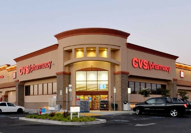

Property Detail
6030 N 43Rd Ave
146-29-134C
A PT OF SE4 OF SEC 9 DAF COM SE COR SD SEC TH W 220.14F TH N 65F TPOB TH N 124.24F TH N 44D 31M W 63.29F TH N 175F TH E 200F TH S 304F TH S 45D 29M W 56.58F TO FLY ROW OF BETHANY HOME RD TH W 115.17F TPOB AS DESC P/F 06-1644734
Storebuilding
Maricopa
C-C
Arizona
C and X Area of minimal flood hazard, usually depicted on FIRMs as above the 500-year flood level.
1
2025
1.41 AC
2025
Glendale
093002
Phoenix
13,366 SF
Phoenix-Mesa-Chandler, AZ
NEARBY LISTINGS FOR SALE OR LEASE
DEMOGRAPHICS near 6030 N 43Rd Ave
1 mile
3 mile
5 mile
2025 Total Population
28,439
214,488
551,349
2030 Population
29,213
220,996
568,763
Pop Growth 2025-2030
+ 2.72%
+ 3.03%
+ 3.16%
Average Age
34
34
35
2025 Total Households
8,577
65,398
180,731
HH Growth 2025-2030
+ 2.76%
+ 3.32%
+ 3.37%
Median Household Inc
$59,779
$54,986
$60,644
Avg Household Size
3.20
3.00
2.90
2025 Avg HH Vehicles
2.00
2.00
2.00
Median Home Value
$284,278
$311,235
$342,827
Median Year Built
1970
1972
1975
Nearby Places
Map Layers
Map Styles
 Street
 Aerial
Layers
 Traffic
 Biking
Places
Listings with unknown addresses are not visible on the map
- Restaurants
- Banks
- Shops
- Fitness
- Groceries
PUBLIC TRANSPORTATION
AIRPORT
Phoenix Sky Harbor International
Drive
Walk
Distance
Phoenix Sky Harbor International
23 min
13.3 mi
Phoenix-Mesa Gateway
Drive
Walk
Distance
Phoenix-Mesa Gateway
56 min
40.5 mi
SALE & LEASE HISTORY
LISTING DATE
SALE/LEASE

Jun 29, 2020
For Sale
Jun 07, 2021
For Sale
Jul 31, 2017
For Lease
Nearby Properties
Address
Land Use
TOTAL SIZE
Lot Size
Zoning
Address
Land Use
TOTAL SIZE
Lot Size
Zoning
96,183 SF
11.04 AC
R-6
Address
Land Use
TOTAL SIZE
Lot Size
Zoning
956,022 SF
14.86 AC
Address
Land Use
TOTAL SIZE
Lot Size
Zoning
281,038 SF
7.71 AC
Address
Land Use
TOTAL SIZE
Lot Size
Zoning
32,600 SF
2.38 AC
R-5
Address
Land Use
TOTAL SIZE
Lot Size
Zoning
337,487 SF
39 AC
R-6
Address
Land Use
TOTAL SIZE
Lot Size
Zoning
474,952 SF
13.68 AC
C-C
Address
Land Use
TOTAL SIZE
Lot Size
Zoning
629,928 SF
41.37 AC
Address
Land Use
TOTAL SIZE
Lot Size
Zoning
276,102 SF
39.72 AC
AG
Address
Land Use
TOTAL SIZE
Lot Size
Zoning
25.91 AC
A1
Address
Land Use
TOTAL SIZE
Lot Size
Zoning
350,874 SF
28.66 AC
C-C
Address
Land Use
TOTAL SIZE
Lot Size
Zoning
1.82 AC
Address
Land Use
TOTAL SIZE
Lot Size
Zoning
211,015 SF
9.59 AC
R-6
Address
Land Use
TOTAL SIZE
Lot Size
Zoning
194,523 SF
37.27 AC
R-6
Address
Land Use
TOTAL SIZE
Lot Size
Zoning
262,609 SF
18.96 AC
I-1
Address
Land Use
TOTAL SIZE
Lot Size
Zoning
200,998 SF
0.06 AC
C-C
Address
Land Use
TOTAL SIZE
Lot Size
Zoning
187,309 SF
19.99 AC
R-6
Address
Land Use
TOTAL SIZE
Lot Size
Zoning
250,180 SF
16.16 AC
C-C
Address
Land Use
TOTAL SIZE
Lot Size
Zoning
217,214 SF
27.12 AC
R-6
Address
Land Use
TOTAL SIZE
Lot Size
Zoning
132,597 SF
59.45 AC
C-2
Address
Land Use
TOTAL SIZE
Lot Size
Zoning
367,133 SF
17.88 AC
IND.PK.
Address
Land Use
TOTAL SIZE
Lot Size
Zoning
2.23 AC
Address
Land Use
TOTAL SIZE
Lot Size
Zoning
13,678 SF
1.88 AC
R-6
Address
Land Use
TOTAL SIZE
Lot Size
Zoning
139,343 SF
10.13 AC
R-6
Address
Land Use
TOTAL SIZE
Lot Size
Zoning
114,671 SF
13.28 AC
R-6
Address
Land Use
TOTAL SIZE
Lot Size
Zoning
120,680 SF
19.15 AC
A-1
Address
Land Use
TOTAL SIZE
Lot Size
Zoning
116,276 SF
11.58 AC
R-6
Address
Land Use
TOTAL SIZE
Lot Size
Zoning
208,448 SF
19.04 AC
C-C
Address
Land Use
TOTAL SIZE
Lot Size
Zoning
153,190 SF
24.67 AC
AG
Address
Land Use
TOTAL SIZE
Lot Size
Zoning
117,165 SF
19.15 AC
M-H
Address
Land Use
TOTAL SIZE
Lot Size
Zoning
305,998 SF
23.38 AC
I-1
The World's #1 Commercial Real Estate Marketplace
Connect with us
© 2026 CoStar Group
The information above has been obtained from sources believed reliable. While we do not doubt its accuracy we have not verified it and make no guarantee, warranty or representation about it. It is your responsibility to independently confirm its accuracy and completeness. Any projections, opinions, assumptions, or estimates used are for example only and do not represent the current or future performance of the property. The value of this transaction to you depends on tax and other factors which should be evaluated by your tax, financial, and legal advisors. You and your advisors should conduct a careful, independent investigation of the property to determine to your satisfaction the suitability of the property for your needs.