Property Record
6030 Us 301 N, Elm City, NC 27822


NEARBY LISTINGS FOR SALE OR LEASE
Property Detail
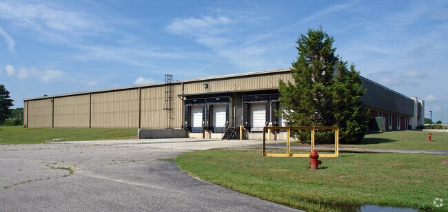
6030 Us 301 N
3735-97-8197.000
Donnelly Marketing Inc
Industrialgeneral
6030 US 301 HWY N 53.86AC
X
Wilson
3720373500J
North Carolina
2024
53.86 AC
2025
Rocky Mount/Wilson
001301
Other Market Areas
43,916 SF
Wilson, NC
DEMOGRAPHICS near 6030 Us 301 N
1 Mile
3 Mile
5 Mile
2024 Total Population
602
3,356
12,063
2029 Population
584
3,234
11,871
Pop Growth 2024-2029
(2.99%)
(3.64%)
(1.59%)
Average Age
43
43
43
2024 Total Households
249
1,396
4,882
HH Growth 2024-2029
(2.81%)
(3.72%)
(1.72%)
Median Household Inc
$43,499
$50,021
$56,657
Avg Household Size
2.40
2.40
2.40
2024 Avg HH Vehicles
2.00
2.00
2.00
Median Home Value
$91,261
$110,519
$157,147
Median Year Built
1981
1981
1986
Nearby Places
Map Layers
Map Styles
 Street
 Aerial
- Restaurants
- Banks
- Shops
- Fitness
- Groceries
PUBLIC TRANSPORTATION
COMMUTER RAIL
Rocky Mount (Carolinian - Amtrak, Palmetto - Amtrak, Silver Meteor - Amtrak, Silver Star - Amtrak)
DRIVE
WALK
Distance
Rocky Mount (Carolinian - Amtrak, Palmetto - Amtrak, Silver Meteor - Amtrak, Silver Star - Amtrak)
13 min
8.8 mi
Wilson (Carolinian - Amtrak, Palmetto - Amtrak)
DRIVE
WALK
Distance
Wilson (Carolinian - Amtrak, Palmetto - Amtrak)
14 min
9.5 mi
AIRPORT
Pitt-Greenville
DRIVE
WALK
Distance
Pitt-Greenville
57 min
45.3 mi
Freight Ports
Port of Morehead City
DRIVE
WALK
Distance
Port of Morehead City
179 min
126.0 mi
Nearby Properties
Address
Land Use
TOTAL SIZE
Lot Size
Zoning
Address
Land Use
TOTAL SIZE
Lot Size
Zoning
11,266 SF
21.70 AC
R10
Address
Land Use
TOTAL SIZE
Lot Size
Zoning
66,151 SF
19.80 AC
RA
Address
Land Use
TOTAL SIZE
Lot Size
Zoning
800 SF
41.43 AC
LI
Address
Land Use
TOTAL SIZE
Lot Size
Zoning
10,464 SF
5.61 AC
R10
Address
Land Use
TOTAL SIZE
Lot Size
Zoning
7,651 SF
10.01 AC
RA
Address
Land Use
TOTAL SIZE
Lot Size
Zoning
11,551 SF
0.44 AC
R10
Address
Land Use
TOTAL SIZE
Lot Size
Zoning
4,000 SF
9.71 AC
RA
Address
Land Use
TOTAL SIZE
Lot Size
Zoning
2,842 SF
3.50 AC
R10
Address
Land Use
TOTAL SIZE
Lot Size
Zoning
7,514 SF
5.63 AC
CH
Address
Land Use
TOTAL SIZE
Lot Size
Zoning
14,556 SF
41.95 AC
RA
Address
Land Use
TOTAL SIZE
Lot Size
Zoning
8,545 SF
1.30 AC
R10
Address
Land Use
TOTAL SIZE
Lot Size
Zoning
14,778 SF
4.35 AC
M1
Address
Land Use
TOTAL SIZE
Lot Size
Zoning
149,324 SF
30.13 AC
Address
Land Use
TOTAL SIZE
Lot Size
Zoning
8,000 SF
0.96 AC
B1
Address
Land Use
TOTAL SIZE
Lot Size
Zoning
5,280 SF
5.75 AC
CH
Address
Land Use
TOTAL SIZE
Lot Size
Zoning
7,200 SF
11.11 AC
RA
Address
Land Use
TOTAL SIZE
Lot Size
Zoning
471.53 AC
Address
Land Use
TOTAL SIZE
Lot Size
Zoning
30,400 SF
5.92 AC
MI
Address
Land Use
TOTAL SIZE
Lot Size
Zoning
2,000 SF
1.34 AC
LI
Address
Land Use
TOTAL SIZE
Lot Size
Zoning
8,000 SF
1.90 AC
RA
Address
Land Use
TOTAL SIZE
Lot Size
Zoning
10,000 SF
12.49 AC
LI
Address
Land Use
TOTAL SIZE
Lot Size
Zoning
9,230 SF
1.44 AC
LI
Address
Land Use
TOTAL SIZE
Lot Size
Zoning
960 SF
60.99 AC
Address
Land Use
TOTAL SIZE
Lot Size
Zoning
25,200 SF
4.19 AC
B1
Address
Land Use
TOTAL SIZE
Lot Size
Zoning
8,000 SF
0.85 AC
B1
Address
Land Use
TOTAL SIZE
Lot Size
Zoning
11,800 SF
10 AC
LI
Address
Land Use
TOTAL SIZE
Lot Size
Zoning
10,739 SF
3.94 AC
B1
Address
Land Use
TOTAL SIZE
Lot Size
Zoning
4,000 SF
1.99 AC
AP
Address
Land Use
TOTAL SIZE
Lot Size
Zoning
5,000 SF
2.07 AC
R20MH
The World's #1 Commercial Real Estate Marketplace
Connect with us
© 2026 CoStar Group
The information above has been obtained from sources believed reliable. While we do not doubt its accuracy we have not verified it and make no guarantee, warranty or representation about it. It is your responsibility to independently confirm its accuracy and completeness. Any projections, opinions, assumptions, or estimates used are for example only and do not represent the current or future performance of the property. The value of this transaction to you depends on tax and other factors which should be evaluated by your tax, financial, and legal advisors. You and your advisors should conduct a careful, independent investigation of the property to determine to your satisfaction the suitability of the property for your needs.