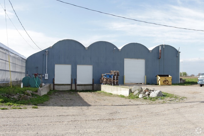
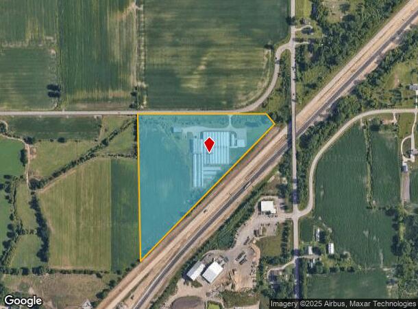
Property Record
6032 144Th Ave, Holland, MI 49423

NEARBY LISTINGS FOR SALE OR LEASE
Property Detail
6032 144Th Ave
11-013-001-10
ALL THAT PT E 1/2 NE 1/4 LYING NW'LY OF US-31 SEC 13 T4N R16W TAX MAP: 17.26 AC (88)
Agriculturalland
Allegan
A
Michigan
26005C0160G
14.92 AC
2024
NE Allegan/Holland
2025
West Michigan
030200
Holland, MI
109,006 SF
DEMOGRAPHICS near 6032 144Th Ave
1 Mile
3 Mile
5 Mile
2024 Total Population
384
20,295
55,255
2029 Population
390
20,891
57,545
Pop Growth 2024-2029
+ 1.56%
+ 2.94%
+ 4.14%
Average Age
43
41
40
2024 Total Households
135
7,944
21,077
HH Growth 2024-2029
+ 1.48%
+ 2.88%
+ 4.27%
Median Household Inc
$88,563
$71,836
$75,577
Avg Household Size
2.80
2.50
2.40
2024 Avg HH Vehicles
3.00
2.00
2.00
Median Home Value
$317,567
$243,542
$255,580
Median Year Built
1978
1971
1974
Nearby Places
Map Layers
Map Styles
 Street
 Aerial
- Restaurants
- Banks
- Shops
- Fitness
- Groceries
PUBLIC TRANSPORTATION
COMMUTER RAIL
Holland Amtrak Station (Pere Marquette - Amtrak)
DRIVE
WALK
Distance
Holland Amtrak Station (Pere Marquette - Amtrak)
13 min
5.4 mi
Freight Ports
Port Milwaukee
DRIVE
WALK
Distance
Port Milwaukee
277 min
232.6 mi
Nearby Properties
Address
Land Use
TOTAL SIZE
Lot Size
Zoning
Address
Land Use
TOTAL SIZE
Lot Size
Zoning
1,788,352 SF
173.33 AC
Address
Land Use
TOTAL SIZE
Lot Size
Zoning
198,712 SF
Address
Land Use
TOTAL SIZE
Lot Size
Zoning
556,819 SF
85.45 AC
Address
Land Use
TOTAL SIZE
Lot Size
Zoning
154,107 SF
Address
Land Use
TOTAL SIZE
Lot Size
Zoning
589,649 SF
92.65 AC
Address
Land Use
TOTAL SIZE
Lot Size
Zoning
114,088 SF
10.79 AC
PRD
Address
Land Use
TOTAL SIZE
Lot Size
Zoning
181,754 SF
13.44 AC
R3
Address
Land Use
TOTAL SIZE
Lot Size
Zoning
372,017 SF
17.60 AC
R-2
Address
Land Use
TOTAL SIZE
Lot Size
Zoning
73,700 SF
Address
Land Use
TOTAL SIZE
Lot Size
Zoning
158,661 SF
17.28 AC
Address
Land Use
TOTAL SIZE
Lot Size
Zoning
122,026 SF
15.03 AC
R3
Address
Land Use
TOTAL SIZE
Lot Size
Zoning
146,357 SF
20.04 AC
Address
Land Use
TOTAL SIZE
Lot Size
Zoning
55,088 SF
Address
Land Use
TOTAL SIZE
Lot Size
Zoning
300,000 SF
Address
Land Use
TOTAL SIZE
Lot Size
Zoning
140,700 SF
20.28 AC
Address
Land Use
TOTAL SIZE
Lot Size
Zoning
133,887 SF
13.50 AC
NA
Address
Land Use
TOTAL SIZE
Lot Size
Zoning
91,294 SF
18.84 AC
NA
Address
Land Use
TOTAL SIZE
Lot Size
Zoning
238,987 SF
38.35 AC
NA
Address
Land Use
TOTAL SIZE
Lot Size
Zoning
123,370 SF
9.89 AC
I2
Address
Land Use
TOTAL SIZE
Lot Size
Zoning
59,836 SF
6.70 AC
NA
Address
Land Use
TOTAL SIZE
Lot Size
Zoning
167,712 SF
6.71 AC
Address
Land Use
TOTAL SIZE
Lot Size
Zoning
39,802 SF
Address
Land Use
TOTAL SIZE
Lot Size
Zoning
22.14 AC
R4
Address
Land Use
TOTAL SIZE
Lot Size
Zoning
232,012 SF
19.69 AC
Address
Land Use
TOTAL SIZE
Lot Size
Zoning
108,970 SF
10.40 AC
I2
Address
Land Use
TOTAL SIZE
Lot Size
Zoning
215,633 SF
26.27 AC
I2
Address
Land Use
TOTAL SIZE
Lot Size
Zoning
134,166 SF
9.18 AC
NA
Address
Land Use
TOTAL SIZE
Lot Size
Zoning
65,000 SF
Address
Land Use
TOTAL SIZE
Lot Size
Zoning
108,282 SF
14.15 AC
I1
Address
Land Use
TOTAL SIZE
Lot Size
Zoning
83,692 SF
6.22 AC
I1
The World's #1 Commercial Real Estate Marketplace
Connect with us
© 2025 CoStar Group
The information above has been obtained from sources believed reliable. While we do not doubt its accuracy we have not verified it and make no guarantee, warranty or representation about it. It is your responsibility to independently confirm its accuracy and completeness. Any projections, opinions, assumptions, or estimates used are for example only and do not represent the current or future performance of the property. The value of this transaction to you depends on tax and other factors which should be evaluated by your tax, financial, and legal advisors. You and your advisors should conduct a careful, independent investigation of the property to determine to your satisfaction the suitability of the property for your needs.