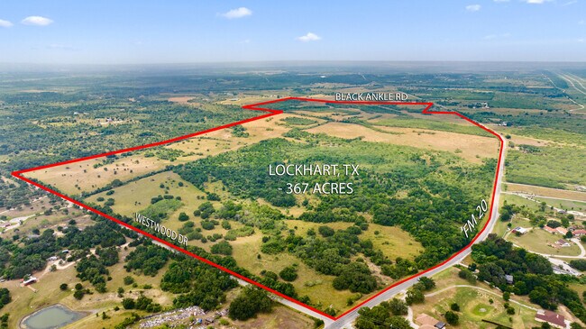
Property Record
6035 State Park Rd, Lockhart, TX 78644
Property Detail
6035 State Park Rd
Austin-Round Rock-San Marcos, TX
A263 STUMPS, JOHN S., ACRES 256.47
16179
CALDWELL
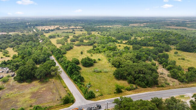
Agriculturalland
Texas
A Areas with a 1% annual chance of flooding and a 26% chance of flooding over the life of a 30-year mortgage.
109.53 AC
2025
Caldwell County
2025
Austin
960102
NEARBY LISTINGS FOR SALE OR LEASE
DEMOGRAPHICS near 6035 State Park Rd
1 mile
3 mile
5 mile
2025 Total Population
200
2,241
20,156
2030 Population
227
2,557
23,003
Pop Growth 2025-2030
+ 13.50%
+ 14.10%
+ 14.12%
Average Age
39
40
40
2025 Total Households
65
785
6,958
HH Growth 2025-2030
+ 13.85%
+ 15.16%
+ 15.38%
Median Household Inc
$71,249
$79,741
$68,462
Avg Household Size
2.80
2.70
2.60
2025 Avg HH Vehicles
3.00
2.00
2.00
Median Home Value
$479,999
$312,222
$249,781
Median Year Built
1993
2002
1990
Nearby Places
Map Layers
Map Styles
 Street
 Aerial
Layers
 Traffic
 Biking
Places
Listings with unknown addresses are not visible on the map
- Restaurants
- Banks
- Shops
- Fitness
- Groceries
PUBLIC TRANSPORTATION
AIRPORT
Austin-Bergstrom International
Drive
Walk
Distance
Austin-Bergstrom International
37 min
28.5 mi
Freight Ports
Calhoun Port
Drive
Walk
Distance
Calhoun Port
153 min
128.2 mi
SALE & LEASE HISTORY
LISTING DATE
SALE/LEASE

Oct 28, 2022
For Sale
Jul 03, 2023
For Sale
Nearby Properties
Address
Land Use
TOTAL SIZE
Lot Size
Zoning
Address
Land Use
TOTAL SIZE
Lot Size
Zoning
152,063 SF
73.48 AC
Address
Land Use
TOTAL SIZE
Lot Size
Zoning
1,489 SF
105.83 AC
Address
Land Use
TOTAL SIZE
Lot Size
Zoning
2,758 SF
6.94 AC
Address
Land Use
TOTAL SIZE
Lot Size
Zoning
2,500 SF
268.41 AC
Address
Land Use
TOTAL SIZE
Lot Size
Zoning
1,388 SF
6 AC
Address
Land Use
TOTAL SIZE
Lot Size
Zoning
18,750 SF
4.16 AC
Address
Land Use
TOTAL SIZE
Lot Size
Zoning
25,785 SF
3.76 AC
Address
Land Use
TOTAL SIZE
Lot Size
Zoning
23,400 SF
1.38 AC
Address
Land Use
TOTAL SIZE
Lot Size
Zoning
14.23 AC
Address
Land Use
TOTAL SIZE
Lot Size
Zoning
44.58 AC
Address
Land Use
TOTAL SIZE
Lot Size
Zoning
9,246 SF
6.68 AC
Address
Land Use
TOTAL SIZE
Lot Size
Zoning
3,645 SF
0.35 AC
Address
Land Use
TOTAL SIZE
Lot Size
Zoning
1,232 SF
20.10 AC
Address
Land Use
TOTAL SIZE
Lot Size
Zoning
2,620 SF
20.84 AC
Address
Land Use
TOTAL SIZE
Lot Size
Zoning
6.03 AC
Address
Land Use
TOTAL SIZE
Lot Size
Zoning
16.51 AC
Address
Land Use
TOTAL SIZE
Lot Size
Zoning
2,641 SF
7 AC
Address
Land Use
TOTAL SIZE
Lot Size
Zoning
4,760 SF
12 AC
Address
Land Use
TOTAL SIZE
Lot Size
Zoning
40.57 AC
Address
Land Use
TOTAL SIZE
Lot Size
Zoning
8.42 AC
Address
Land Use
TOTAL SIZE
Lot Size
Zoning
2,574 SF
2.03 AC
Address
Land Use
TOTAL SIZE
Lot Size
Zoning
15,001 SF
0.35 AC
Address
Land Use
TOTAL SIZE
Lot Size
Zoning
6,012 SF
8.25 AC
Address
Land Use
TOTAL SIZE
Lot Size
Zoning
4.82 AC
Address
Land Use
TOTAL SIZE
Lot Size
Zoning
1,000 SF
11.72 AC
Address
Land Use
TOTAL SIZE
Lot Size
Zoning
652 SF
122.88 AC
Address
Land Use
TOTAL SIZE
Lot Size
Zoning
2.24 AC
Address
Land Use
TOTAL SIZE
Lot Size
Zoning
22.26 AC
Address
Land Use
TOTAL SIZE
Lot Size
Zoning
241 SF
7.21 AC
Address
Land Use
TOTAL SIZE
Lot Size
Zoning
3,870 SF
5.02 AC
The World's #1 Commercial Real Estate Marketplace
Connect with us
© 2026 CoStar Group
The information above has been obtained from sources believed reliable. While we do not doubt its accuracy we have not verified it and make no guarantee, warranty or representation about it. It is your responsibility to independently confirm its accuracy and completeness. Any projections, opinions, assumptions, or estimates used are for example only and do not represent the current or future performance of the property. The value of this transaction to you depends on tax and other factors which should be evaluated by your tax, financial, and legal advisors. You and your advisors should conduct a careful, independent investigation of the property to determine to your satisfaction the suitability of the property for your needs.