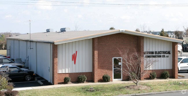
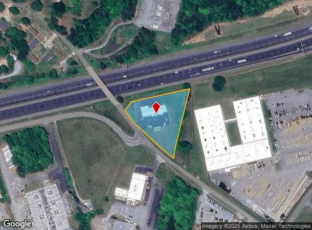
Property Record
604 E Gilbreath St, Graham, NC 27253

NEARBY LISTINGS FOR SALE OR LEASE
Property Detail
604 E Gilbreath St
146711
BL 604 E GILBREATH ST TRACT 2B 6-25-8A
Multipleuses
Alamance
X
North Carolina
3710888400K
1.96 AC
2025
S Central Alamance County
2025
Greensboro/Winston-Salem
021102
Burlington, NC
5,920 SF
DEMOGRAPHICS near 604 E Gilbreath St
1 Mile
3 Mile
5 Mile
2024 Total Population
7,688
37,379
82,910
2029 Population
8,390
40,444
89,796
Pop Growth 2024-2029
+ 9.13%
+ 8.20%
+ 8.31%
Average Age
40
39
40
2024 Total Households
3,324
15,040
33,620
HH Growth 2024-2029
+ 9.42%
+ 8.43%
+ 8.47%
Median Household Inc
$47,625
$48,126
$49,421
Avg Household Size
2.20
2.40
2.40
2024 Avg HH Vehicles
2.00
2.00
2.00
Median Home Value
$168,019
$156,044
$163,759
Median Year Built
1985
1976
1978
Nearby Places
Map Layers
Map Styles
 Street
 Aerial
- Restaurants
- Banks
- Shops
- Fitness
- Groceries
PUBLIC TRANSPORTATION
COMMUTER RAIL
Burlington Station (Piedmont - North Carolina by Train (NC Train))
DRIVE
WALK
Distance
Burlington Station (Piedmont - North Carolina by Train (NC Train))
7 min
3.9 mi
AIRPORT
Piedmont Triad International
DRIVE
WALK
Distance
Piedmont Triad International
49 min
34.4 mi
Raleigh-Durham International
DRIVE
WALK
Distance
Raleigh-Durham International
55 min
43.0 mi
Nearby Properties
Address
Land Use
TOTAL SIZE
Lot Size
Zoning
Address
Land Use
TOTAL SIZE
Lot Size
Zoning
2,315 SF
55.43 AC
I 1
Address
Land Use
TOTAL SIZE
Lot Size
Zoning
159,629 SF
82.81 AC
Address
Land Use
TOTAL SIZE
Lot Size
Zoning
27,803 SF
13.10 AC
B 2
Address
Land Use
TOTAL SIZE
Lot Size
Zoning
578,100 SF
55.30 AC
Address
Land Use
TOTAL SIZE
Lot Size
Zoning
48,136 SF
14.57 AC
B 2
Address
Land Use
TOTAL SIZE
Lot Size
Zoning
37,502 SF
17.48 AC
CR
Address
Land Use
TOTAL SIZE
Lot Size
Zoning
27,803 SF
11.53 AC
Address
Land Use
TOTAL SIZE
Lot Size
Zoning
33,280 SF
9.07 AC
I2
Address
Land Use
TOTAL SIZE
Lot Size
Zoning
296,940 SF
33.78 AC
Address
Land Use
TOTAL SIZE
Lot Size
Zoning
84,881 SF
52.87 AC
I1
Address
Land Use
TOTAL SIZE
Lot Size
Zoning
72,164 SF
73.50 AC
Address
Land Use
TOTAL SIZE
Lot Size
Zoning
10,368 SF
11.35 AC
R MF
Address
Land Use
TOTAL SIZE
Lot Size
Zoning
51,994 SF
42.20 AC
OI
Address
Land Use
TOTAL SIZE
Lot Size
Zoning
71,962 SF
5.98 AC
O I
Address
Land Use
TOTAL SIZE
Lot Size
Zoning
216,968 SF
25.50 AC
CB
Address
Land Use
TOTAL SIZE
Lot Size
Zoning
31,920 SF
4.59 AC
R MF
Address
Land Use
TOTAL SIZE
Lot Size
Zoning
7,192 SF
14.08 AC
RMF
Address
Land Use
TOTAL SIZE
Lot Size
Zoning
36,000 SF
4.43 AC
Address
Land Use
TOTAL SIZE
Lot Size
Zoning
9,008 SF
6.23 AC
R MF
Address
Land Use
TOTAL SIZE
Lot Size
Zoning
2,923 SF
10.13 AC
Address
Land Use
TOTAL SIZE
Lot Size
Zoning
158,339 SF
16.34 AC
Address
Land Use
TOTAL SIZE
Lot Size
Zoning
20,000 SF
17.24 AC
I 1A
Address
Land Use
TOTAL SIZE
Lot Size
Zoning
22,301 SF
19.25 AC
OI
Address
Land Use
TOTAL SIZE
Lot Size
Zoning
60,458 SF
6.82 AC
I 2
Address
Land Use
TOTAL SIZE
Lot Size
Zoning
45,321 SF
31 AC
R 12
Address
Land Use
TOTAL SIZE
Lot Size
Zoning
8,312 SF
10.41 AC
Address
Land Use
TOTAL SIZE
Lot Size
Zoning
7,800 SF
5.51 AC
Address
Land Use
TOTAL SIZE
Lot Size
Zoning
43,170 SF
6.80 AC
O I
Address
Land Use
TOTAL SIZE
Lot Size
Zoning
41,787 SF
8.07 AC
COI
Address
Land Use
TOTAL SIZE
Lot Size
Zoning
8,970 SF
11.57 AC
I&C
The World's #1 Commercial Real Estate Marketplace
Connect with us
© 2026 CoStar Group
The information above has been obtained from sources believed reliable. While we do not doubt its accuracy we have not verified it and make no guarantee, warranty or representation about it. It is your responsibility to independently confirm its accuracy and completeness. Any projections, opinions, assumptions, or estimates used are for example only and do not represent the current or future performance of the property. The value of this transaction to you depends on tax and other factors which should be evaluated by your tax, financial, and legal advisors. You and your advisors should conduct a careful, independent investigation of the property to determine to your satisfaction the suitability of the property for your needs.