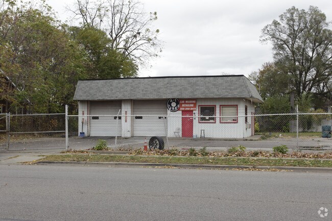
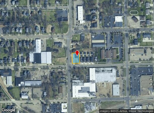
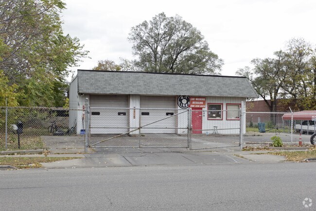
Property Record
604 N Westnedge Ave, Kalamazoo, MI 49007
NEARBY LISTINGS FOR SALE OR LEASE
Property Detail
604 N Westnedge Ave
Kalamazoo-Portage, MI
ORIGINAL PLAT OF THE TOWN (NOW CITY) OF KALAMAZOO; LIBER 6 OF PLATS PAGE 8; PART OF LOT 6 IN BLOCK 32 & BLANK LOT BETWEEN
06-15-165-210
Kalamazoo
Commercialnec
Michigan
2024
6
2025
0.23 AC
000300
Central Kalamazoo
1,260 SF
West Michigan
DEMOGRAPHICS near 604 N Westnedge Ave
1 Mile
3 Mile
5 Mile
2024 Total Population
14,635
82,070
143,875
2029 Population
14,883
82,276
143,913
Pop Growth 2024-2029
+ 1.69%
+ 0.25%
+ 0.03%
Average Age
33
35
36
2024 Total Households
6,264
32,916
60,876
HH Growth 2024-2029
+ 1.88%
+ 0.29%
+ 0.02%
Median Household Inc
$29,862
$44,416
$49,078
Avg Household Size
2.10
2.20
2.20
2024 Avg HH Vehicles
1.00
2.00
2.00
Median Home Value
$104,004
$146,879
$164,916
Median Year Built
1948
1958
1968
Nearby Places
Map Layers
Map Styles
 Street
 Aerial
- Restaurants
- Banks
- Shops
- Fitness
- Groceries
PUBLIC TRANSPORTATION
COMMUTER RAIL
DRIVE
WALK
Distance
2 min
7 min
0.4 mi
AIRPORT
Kalamazoo/Battle Creek International
DRIVE
WALK
Distance
Kalamazoo/Battle Creek International
18 min
7.8 mi
Nearby Properties
Address
Land Use
TOTAL SIZE
Lot Size
Zoning
Address
Land Use
TOTAL SIZE
Lot Size
Zoning
632,218 SF
10.84 AC
M-1
Address
Land Use
TOTAL SIZE
Lot Size
Zoning
374,906 SF
16.31 AC
RM-36
Address
Land Use
TOTAL SIZE
Lot Size
Zoning
289,865 SF
23.60 AC
PUD
Address
Land Use
TOTAL SIZE
Lot Size
Zoning
35,870 SF
12.78 AC
CC
Address
Land Use
TOTAL SIZE
Lot Size
Zoning
329,276 SF
43.86 AC
RM-1
Address
Land Use
TOTAL SIZE
Lot Size
Zoning
429,500 SF
2 AC
CCBD
Address
Land Use
TOTAL SIZE
Lot Size
Zoning
315,422 SF
25.40 AC
RM-15
Address
Land Use
TOTAL SIZE
Lot Size
Zoning
877,422 SF
38.18 AC
M-2
Address
Land Use
TOTAL SIZE
Lot Size
Zoning
14,095 SF
27.05 AC
PUD
Address
Land Use
TOTAL SIZE
Lot Size
Zoning
291,495 SF
18.39 AC
PUD
Address
Land Use
TOTAL SIZE
Lot Size
Zoning
105,046 SF
19.30 AC
RM-15
Address
Land Use
TOTAL SIZE
Lot Size
Zoning
273,122 SF
16.12 AC
PUD
Address
Land Use
TOTAL SIZE
Lot Size
Zoning
201,940 SF
9.30 AC
RM-36
Address
Land Use
TOTAL SIZE
Lot Size
Zoning
110,686 SF
9.45 AC
CCBD
Address
Land Use
TOTAL SIZE
Lot Size
Zoning
390,900 SF
14 AC
I-M IND
Address
Land Use
TOTAL SIZE
Lot Size
Zoning
275,595 SF
0.65 AC
CCBD
Address
Land Use
TOTAL SIZE
Lot Size
Zoning
Address
Land Use
TOTAL SIZE
Lot Size
Zoning
50,826 SF
0.79 AC
CCBD
Address
Land Use
TOTAL SIZE
Lot Size
Zoning
186,652 SF
28.29 AC
PUD
Address
Land Use
TOTAL SIZE
Lot Size
Zoning
274,412 SF
12.10 AC
RM-1
Address
Land Use
TOTAL SIZE
Lot Size
Zoning
179,628 SF
12.99 AC
RM-15
Address
Land Use
TOTAL SIZE
Lot Size
Zoning
99,092 SF
1.45 AC
CCBD
Address
Land Use
TOTAL SIZE
Lot Size
Zoning
98,401 SF
2.94 AC
RM-15
Address
Land Use
TOTAL SIZE
Lot Size
Zoning
110,656 SF
7.54 AC
RM-15
Address
Land Use
TOTAL SIZE
Lot Size
Zoning
161,530 SF
10.01 AC
RM-15
Address
Land Use
TOTAL SIZE
Lot Size
Zoning
74,931 SF
7.53 AC
CO
Address
Land Use
TOTAL SIZE
Lot Size
Zoning
171,772 SF
0.68 AC
CCBD
Address
Land Use
TOTAL SIZE
Lot Size
Zoning
49,894 SF
7.09 AC
RM-15
Address
Land Use
TOTAL SIZE
Lot Size
Zoning
100,284 SF
5.77 AC
RM-15
Address
Land Use
TOTAL SIZE
Lot Size
Zoning
232,072 SF
21.21 AC
PUD
The World's #1 Commercial Real Estate Marketplace
Connect with us
© 2025 CoStar Group
The information above has been obtained from sources believed reliable. While we do not doubt its accuracy we have not verified it and make no guarantee, warranty or representation about it. It is your responsibility to independently confirm its accuracy and completeness. Any projections, opinions, assumptions, or estimates used are for example only and do not represent the current or future performance of the property. The value of this transaction to you depends on tax and other factors which should be evaluated by your tax, financial, and legal advisors. You and your advisors should conduct a careful, independent investigation of the property to determine to your satisfaction the suitability of the property for your needs.