Property Record
800 Otis Dr, Dover, DE 19901
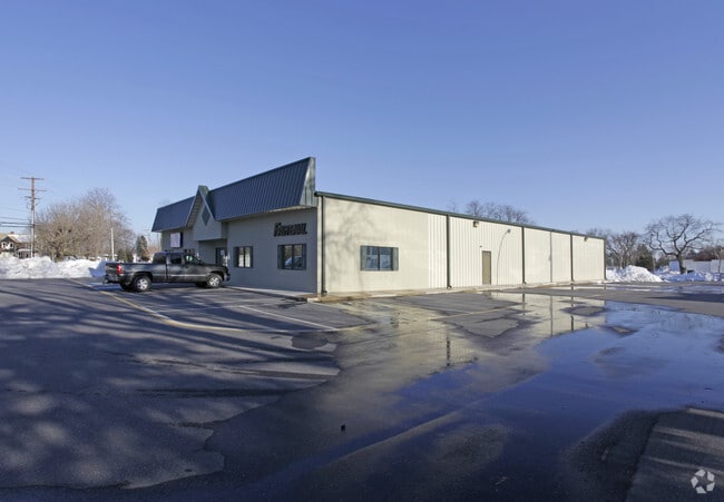

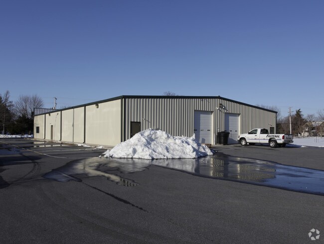
Property Detail
800 Otis Dr
2-05-07712-01-0200-000
DOVER-LITTLE CREEK, 19.992 A.
Commercialnec
Kent
C3
Delaware
B and X Area of moderate flood hazard, usually the area between the limits of the 100-year and 500-year floods.
19.99 AC
2025
Kent County
2025
Philadelphia
041000
Dover, DE
15,000 SF
NEARBY LISTINGS FOR SALE OR LEASE
DEMOGRAPHICS near 800 Otis Dr
1 mile
3 mile
5 mile
2025 Total Population
5,827
39,424
74,847
2030 Population
6,072
41,409
78,415
Pop Growth 2025-2030
+ 4.20%
+ 5.04%
+ 4.77%
Average Age
37
38
38
2025 Total Households
2,357
16,064
28,568
HH Growth 2025-2030
+ 4.20%
+ 6.09%
+ 5.41%
Median Household Inc
$57,746
$58,436
$66,928
Avg Household Size
2.30
2.30
2.40
2025 Avg HH Vehicles
1.00
2.00
2.00
Median Home Value
$234,464
$252,941
$296,144
Median Year Built
1986
1983
1988
Nearby Places
Map Layers
Map Styles
 Street
 Aerial
Transit
 Traffic
 Biking
Places
Listings with unknown addresses are not visible on the map
- Restaurants
- Banks
- Shops
- Fitness
- Groceries
Nearby Properties
Address
Land Use
TOTAL SIZE
Lot Size
Zoning
Address
Land Use
TOTAL SIZE
Lot Size
Zoning
231,470 SF
213.60 AC
IO
Address
Land Use
TOTAL SIZE
Lot Size
Zoning
136,308 SF
2,301.50 AC
R20
Address
Land Use
TOTAL SIZE
Lot Size
Zoning
824,144 SF
12.10 AC
IO
Address
Land Use
TOTAL SIZE
Lot Size
Zoning
Address
Land Use
TOTAL SIZE
Lot Size
Zoning
247,145 SF
43.71 AC
CPO
Address
Land Use
TOTAL SIZE
Lot Size
Zoning
1,120 SF
181.50 AC
RC
Address
Land Use
TOTAL SIZE
Lot Size
Zoning
189,363 SF
123.90 AC
IO
Address
Land Use
TOTAL SIZE
Lot Size
Zoning
172,440 SF
28.86 AC
RM2
Address
Land Use
TOTAL SIZE
Lot Size
Zoning
322,096 SF
18.20 AC
SC2
Address
Land Use
TOTAL SIZE
Lot Size
Zoning
105,846 SF
15.79 AC
SC2
Address
Land Use
TOTAL SIZE
Lot Size
Zoning
567,080 SF
30.22 AC
IPM
Address
Land Use
TOTAL SIZE
Lot Size
Zoning
179,601 SF
42.90 AC
IO
Address
Land Use
TOTAL SIZE
Lot Size
Zoning
93,186 SF
89.27 AC
IPM
Address
Land Use
TOTAL SIZE
Lot Size
Zoning
228,076 SF
15.50 AC
BG
Address
Land Use
TOTAL SIZE
Lot Size
Zoning
129,471 SF
TND
Address
Land Use
TOTAL SIZE
Lot Size
Zoning
108,450 SF
11 AC
RM
Address
Land Use
TOTAL SIZE
Lot Size
Zoning
116,604 SF
3.20 AC
IO
Address
Land Use
TOTAL SIZE
Lot Size
Zoning
187,104 SF
7.80 AC
RM1
Address
Land Use
TOTAL SIZE
Lot Size
Zoning
72,794 SF
11.57 AC
IO
Address
Land Use
TOTAL SIZE
Lot Size
Zoning
Address
Land Use
TOTAL SIZE
Lot Size
Zoning
60,324 SF
6.70 AC
IO
Address
Land Use
TOTAL SIZE
Lot Size
Zoning
Address
Land Use
TOTAL SIZE
Lot Size
Zoning
434.50 AC
DAFB
Address
Land Use
TOTAL SIZE
Lot Size
Zoning
243,410 SF
43.20 AC
IPM
Address
Land Use
TOTAL SIZE
Lot Size
Zoning
421,941 SF
23.70 AC
IPM
Address
Land Use
TOTAL SIZE
Lot Size
Zoning
111,744 SF
11.47 AC
RG2
Address
Land Use
TOTAL SIZE
Lot Size
Zoning
113,226 SF
2.50 AC
IO
Address
Land Use
TOTAL SIZE
Lot Size
Zoning
105,470 SF
6.90 AC
IO
Address
Land Use
TOTAL SIZE
Lot Size
Zoning
168,550 SF
22.40 AC
IO
Address
Land Use
TOTAL SIZE
Lot Size
Zoning
The World's #1 Commercial Real Estate Marketplace
Connect with us
© 2026 CoStar Group
The information above has been obtained from sources believed reliable. While we do not doubt its accuracy we have not verified it and make no guarantee, warranty or representation about it. It is your responsibility to independently confirm its accuracy and completeness. Any projections, opinions, assumptions, or estimates used are for example only and do not represent the current or future performance of the property. The value of this transaction to you depends on tax and other factors which should be evaluated by your tax, financial, and legal advisors. You and your advisors should conduct a careful, independent investigation of the property to determine to your satisfaction the suitability of the property for your needs.