Property Record
6042 Service Rd, Trussville, AL 35173
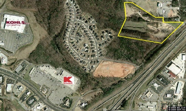
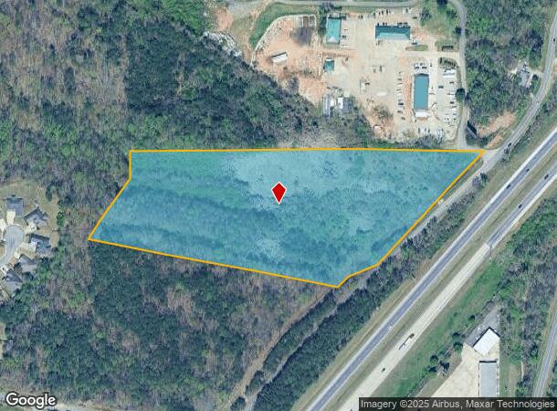
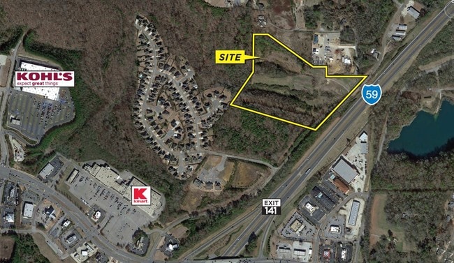
This Property Is For Sale
NEARBY LISTINGS FOR SALE OR LEASE
Property Detail
6042 Service Rd
12-00-14-2-000-015.000
COM NE COR SE 1/4 NW 1/4 TH W 485 FT S TO BEG TH W 852 FT S TH S 95 FT S TH SW 255 FT S TH SE 925 FT S TO NW ROW I-59 TH NELY 700 FT S ALONG SAID ROW TO POB BEING PT S 1/2 NW 1/4 SEC 14 TP 16 R 1W
Vacantlandnec
Jefferson
X
Alabama
01073C0263H
11 AC
2023
Trussville
2024
Birmingham
0111111082
Birmingham, AL
DEMOGRAPHICS near 6042 Service Rd
1 Mile
3 Mile
5 Mile
2024 Total Population
2,150
29,213
78,048
2029 Population
2,077
28,275
76,159
Pop Growth 2024-2029
(3.40%)
(3.21%)
(2.42%)
Average Age
41
39
38
2024 Total Households
795
10,954
28,979
HH Growth 2024-2029
(3.52%)
(3.30%)
(2.49%)
Median Household Inc
$89,062
$70,444
$62,015
Avg Household Size
2.60
2.60
2.60
2024 Avg HH Vehicles
2.00
2.00
2.00
Median Home Value
$307,039
$199,420
$180,590
Median Year Built
1995
1989
1982
Nearby Places
Map Layers
Map Styles
 Street
 Aerial
- Restaurants
- Banks
- Shops
- Fitness
- Groceries
PUBLIC TRANSPORTATION
AIRPORT
Birmingham-Shuttlesworth International
DRIVE
WALK
Distance
Birmingham-Shuttlesworth International
17 min
12.3 mi
Freight Ports
Port of Mobile
DRIVE
WALK
Distance
Port of Mobile
293 min
267.6 mi
Nearby Properties
Address
Land Use
TOTAL SIZE
Lot Size
Zoning
Address
Land Use
TOTAL SIZE
Lot Size
Zoning
346,184 SF
21.75 AC
I2
Address
Land Use
TOTAL SIZE
Lot Size
Zoning
204,463 SF
32.90 AC
PUD
Address
Land Use
TOTAL SIZE
Lot Size
Zoning
144,921 SF
9 AC
R4
Address
Land Use
TOTAL SIZE
Lot Size
Zoning
87,863 SF
13.20 AC
PUD
Address
Land Use
TOTAL SIZE
Lot Size
Zoning
204,269 SF
17.94 AC
PUD
Address
Land Use
TOTAL SIZE
Lot Size
Zoning
134,442 SF
26 AC
PUD
Address
Land Use
TOTAL SIZE
Lot Size
Zoning
89,935 SF
29.32 AC
A1
Address
Land Use
TOTAL SIZE
Lot Size
Zoning
176,232 SF
5.20 AC
C2
Address
Land Use
TOTAL SIZE
Lot Size
Zoning
34,169 SF
2.56 AC
QC2
Address
Land Use
TOTAL SIZE
Lot Size
Zoning
49,858 SF
7.30 AC
C4
Address
Land Use
TOTAL SIZE
Lot Size
Zoning
74,218 SF
4.50 AC
C2
Address
Land Use
TOTAL SIZE
Lot Size
Zoning
62,944 SF
8.44 AC
C1
Address
Land Use
TOTAL SIZE
Lot Size
Zoning
97,652 SF
6.20 AC
C2
Address
Land Use
TOTAL SIZE
Lot Size
Zoning
89,761 SF
11 AC
PUD
Address
Land Use
TOTAL SIZE
Lot Size
Zoning
116,732 SF
4.06 AC
R-4
Address
Land Use
TOTAL SIZE
Lot Size
Zoning
55,760 SF
24.85 AC
A1
Address
Land Use
TOTAL SIZE
Lot Size
Zoning
87,142 SF
10.80 AC
C-2
Address
Land Use
TOTAL SIZE
Lot Size
Zoning
29,422 SF
5.31 AC
C2
Address
Land Use
TOTAL SIZE
Lot Size
Zoning
55,000 SF
7.10 AC
C2&I
Address
Land Use
TOTAL SIZE
Lot Size
Zoning
43,451 SF
5.22 AC
INST
Address
Land Use
TOTAL SIZE
Lot Size
Zoning
67,270 SF
9.70 AC
C2
Address
Land Use
TOTAL SIZE
Lot Size
Zoning
11,872 SF
3.38 AC
QC2
Address
Land Use
TOTAL SIZE
Lot Size
Zoning
48,483 SF
5.05 AC
C1
Address
Land Use
TOTAL SIZE
Lot Size
Zoning
43,298 SF
5.59 AC
INST
Address
Land Use
TOTAL SIZE
Lot Size
Zoning
4.21 AC
C2
Address
Land Use
TOTAL SIZE
Lot Size
Zoning
49,868 SF
4.91 AC
C1
Address
Land Use
TOTAL SIZE
Lot Size
Zoning
42.72 AC
R1
Address
Land Use
TOTAL SIZE
Lot Size
Zoning
19,632 SF
1.79 AC
QC2
Address
Land Use
TOTAL SIZE
Lot Size
Zoning
58,296 SF
6.25 AC
PUD
The World's #1 Commercial Real Estate Marketplace
Connect with us
© 2026 CoStar Group
The information above has been obtained from sources believed reliable. While we do not doubt its accuracy we have not verified it and make no guarantee, warranty or representation about it. It is your responsibility to independently confirm its accuracy and completeness. Any projections, opinions, assumptions, or estimates used are for example only and do not represent the current or future performance of the property. The value of this transaction to you depends on tax and other factors which should be evaluated by your tax, financial, and legal advisors. You and your advisors should conduct a careful, independent investigation of the property to determine to your satisfaction the suitability of the property for your needs.