Property Record
6045 E 39Th St, Kearney, NE 68847
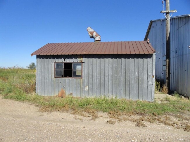
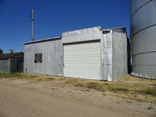
This Property Is For Sale
NEARBY LISTINGS FOR SALE OR LEASE
Property Detail
6045 E 39Th St
620180000
Ingram Subdivision
Sfr
34-9-15 PT NW1/4 S OF RR (118.82A)
X
Buffalo
31019C0610D
Nebraska
2024
1.50 AC
2025
I-80 Corridor
969500
Other Market Areas
1,248 SF
Kearney, NE
DEMOGRAPHICS near 6045 E 39Th St
1 Mile
3 Mile
5 Mile
2024 Total Population
34
1,506
23,198
2029 Population
36
1,568
24,009
Pop Growth 2024-2029
+ 5.88%
+ 4.12%
+ 3.50%
Average Age
40
38
38
2024 Total Households
14
606
9,262
HH Growth 2024-2029
+ 7.14%
+ 4.29%
+ 3.56%
Median Household Inc
$43,749
$60,912
$62,882
Avg Household Size
2.20
2.40
2.30
2024 Avg HH Vehicles
2.00
2.00
2.00
Median Home Value
$225,000
$221,226
$196,448
Median Year Built
1992
1990
1977
Nearby Places
Map Layers
Map Styles
 Street
 Aerial
- Restaurants
- Banks
- Shops
- Fitness
- Groceries
Nearby Properties
Address
Land Use
TOTAL SIZE
Lot Size
Zoning
Address
Land Use
TOTAL SIZE
Lot Size
Zoning
412,500 SF
61.21 AC
INDUSTRIAL
Address
Land Use
TOTAL SIZE
Lot Size
Zoning
55,080 SF
44.96 AC
INDUSTRIAL
Address
Land Use
TOTAL SIZE
Lot Size
Zoning
60,000 SF
19.93 AC
INDUSTRIAL
Address
Land Use
TOTAL SIZE
Lot Size
Zoning
101,588 SF
10.51 AC
COMMERCIAL
Address
Land Use
TOTAL SIZE
Lot Size
Zoning
5,000 SF
53.38 AC
INDUSTRIAL
Address
Land Use
TOTAL SIZE
Lot Size
Zoning
170,410 SF
19.42 AC
INDUSTRIAL
Address
Land Use
TOTAL SIZE
Lot Size
Zoning
71,835 SF
37.66 AC
COMMERCIAL
Address
Land Use
TOTAL SIZE
Lot Size
Zoning
18,302 SF
10 AC
COMMERCIAL
Address
Land Use
TOTAL SIZE
Lot Size
Zoning
99,750 SF
12.70 AC
INDUSTRIAL
Address
Land Use
TOTAL SIZE
Lot Size
Zoning
12,000 SF
4.81 AC
COMMERCIAL
Address
Land Use
TOTAL SIZE
Lot Size
Zoning
10,546 SF
5.05 AC
COMMERCIAL
Address
Land Use
TOTAL SIZE
Lot Size
Zoning
35,000 SF
8.43 AC
COMMERCIAL
Address
Land Use
TOTAL SIZE
Lot Size
Zoning
12,500 SF
10.09 AC
COMMERCIAL
Address
Land Use
TOTAL SIZE
Lot Size
Zoning
1,750 SF
9.40 AC
COMMERCIAL
Address
Land Use
TOTAL SIZE
Lot Size
Zoning
11,074 SF
9.89 AC
COMMERCIAL
Address
Land Use
TOTAL SIZE
Lot Size
Zoning
24,500 SF
14.66 AC
INDUSTRIAL
Address
Land Use
TOTAL SIZE
Lot Size
Zoning
16,500 SF
19.14 AC
COMMERCIAL
Address
Land Use
TOTAL SIZE
Lot Size
Zoning
28,240 SF
11.73 AC
INDUSTRIAL
Address
Land Use
TOTAL SIZE
Lot Size
Zoning
4,000 SF
8.47 AC
INDUSTRIAL
Address
Land Use
TOTAL SIZE
Lot Size
Zoning
1,046 SF
1.14 AC
MULTI-FAMI
Address
Land Use
TOTAL SIZE
Lot Size
Zoning
14,500 SF
16.92 AC
INDUSTRIAL
Address
Land Use
TOTAL SIZE
Lot Size
Zoning
14,889 SF
2.10 AC
INDUSTRIAL
Address
Land Use
TOTAL SIZE
Lot Size
Zoning
11,520 SF
1.57 AC
COMMERCIAL
Address
Land Use
TOTAL SIZE
Lot Size
Zoning
12,000 SF
2.96 AC
INDUSTRIAL
Address
Land Use
TOTAL SIZE
Lot Size
Zoning
16,420 SF
1.33 AC
MULTI-FAMI
Address
Land Use
TOTAL SIZE
Lot Size
Zoning
30,180 SF
2.59 AC
COMMERCIAL
Address
Land Use
TOTAL SIZE
Lot Size
Zoning
1,902 SF
193.88 AC
AGRICULTUR
Address
Land Use
TOTAL SIZE
Lot Size
Zoning
6,292 SF
5.35 AC
COMMERCIAL
Address
Land Use
TOTAL SIZE
Lot Size
Zoning
16,140 SF
3.04 AC
INDUSTRIAL
Address
Land Use
TOTAL SIZE
Lot Size
Zoning
3,900 SF
1.46 AC
INDUSTRIAL
The World's #1 Commercial Real Estate Marketplace
Connect with us
© 2026 CoStar Group
The information above has been obtained from sources believed reliable. While we do not doubt its accuracy we have not verified it and make no guarantee, warranty or representation about it. It is your responsibility to independently confirm its accuracy and completeness. Any projections, opinions, assumptions, or estimates used are for example only and do not represent the current or future performance of the property. The value of this transaction to you depends on tax and other factors which should be evaluated by your tax, financial, and legal advisors. You and your advisors should conduct a careful, independent investigation of the property to determine to your satisfaction the suitability of the property for your needs.