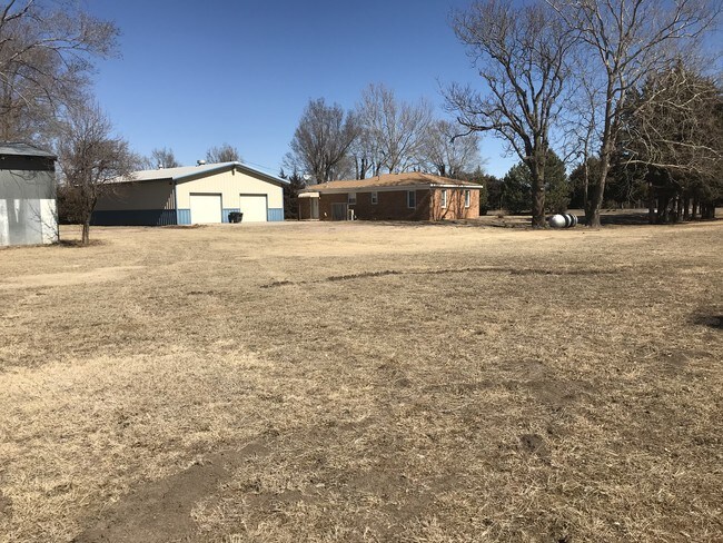
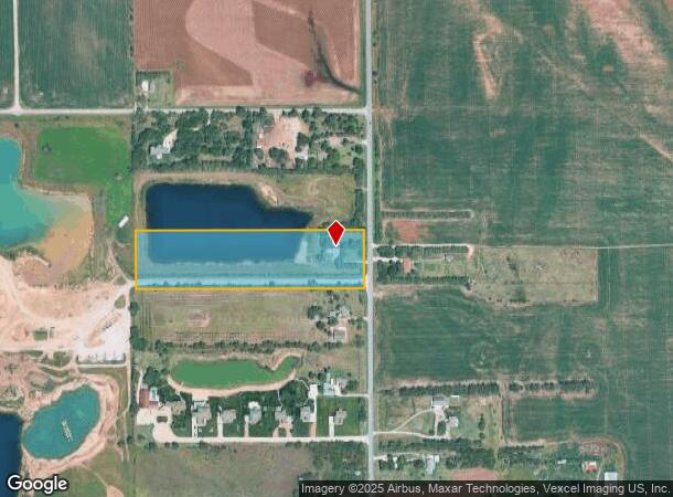
Property Record
6049 N Ridge Rd, Maize, KS 67101

NEARBY LISTINGS FOR SALE OR LEASE
Property Detail
6049 N Ridge Rd
085-16-0-11-00-006.00
BEG 658.36 FT S NE COR NE1/4 S 328.48 FT W 1326 FT M-L N 328.48 FT E TO BEG SEC 16-26-1W
Farms
Sedgwick
X
Kansas
20173C0191G
3.22 AC
2024
Outlying Sedgwick County
2025
Wichita
010302
Wichita, KS
1,229 SF
DEMOGRAPHICS near 6049 N Ridge Rd
1 Mile
3 Mile
5 Mile
2024 Total Population
147
7,978
40,364
2029 Population
153
8,236
41,145
Pop Growth 2024-2029
+ 4.08%
+ 3.23%
+ 1.93%
Average Age
33
37
39
2024 Total Households
47
2,816
14,655
HH Growth 2024-2029
+ 4.26%
+ 3.16%
+ 1.90%
Median Household Inc
$43,749
$71,317
$87,389
Avg Household Size
3.00
2.80
2.70
2024 Avg HH Vehicles
2.00
2.00
2.00
Median Home Value
$304,545
$264,669
$250,945
Median Year Built
2010
2006
1998
Nearby Places
Map Layers
Map Styles
 Street
 Aerial
- Restaurants
- Banks
- Shops
- Fitness
- Groceries
PUBLIC TRANSPORTATION
AIRPORT
Wichita Dwight D Eisenhower Ntl
DRIVE
WALK
Distance
Wichita Dwight D Eisenhower Ntl
20 min
9.9 mi
Freight Ports
Tulsa Port Of Catoosa
DRIVE
WALK
Distance
Tulsa Port Of Catoosa
221 min
205.2 mi
SALE & LEASE HISTORY
LISTING DATE
SALE/LEASE

Apr 09, 2018
For Sale
Nearby Properties
Address
Land Use
TOTAL SIZE
Lot Size
Zoning
Address
Land Use
TOTAL SIZE
Lot Size
Zoning
175,639 SF
22.91 AC
SF-5
Address
Land Use
TOTAL SIZE
Lot Size
Zoning
104,252 SF
7.24 AC
SF-5
Address
Land Use
TOTAL SIZE
Lot Size
Zoning
89,126 SF
34.29 AC
R6
Address
Land Use
TOTAL SIZE
Lot Size
Zoning
77,159 SF
5.97 AC
SF-5
Address
Land Use
TOTAL SIZE
Lot Size
Zoning
84,317 SF
7.18 AC
SF-5
Address
Land Use
TOTAL SIZE
Lot Size
Zoning
68,496 SF
18.11 AC
LC
Address
Land Use
TOTAL SIZE
Lot Size
Zoning
36,818 SF
14.91 AC
SF-5
Address
Land Use
TOTAL SIZE
Lot Size
Zoning
18,125 SF
5.91 AC
SF-5
Address
Land Use
TOTAL SIZE
Lot Size
Zoning
53,446 SF
6.67 AC
LC
Address
Land Use
TOTAL SIZE
Lot Size
Zoning
34,983 SF
4.51 AC
LC
Address
Land Use
TOTAL SIZE
Lot Size
Zoning
29,079 SF
4.45 AC
LC
Address
Land Use
TOTAL SIZE
Lot Size
Zoning
8,796 SF
1.71 AC
LC
Address
Land Use
TOTAL SIZE
Lot Size
Zoning
70,165 SF
4.73 AC
LC
Address
Land Use
TOTAL SIZE
Lot Size
Zoning
46,450 SF
10.33 AC
LI
Address
Land Use
TOTAL SIZE
Lot Size
Zoning
32,063 SF
3.44 AC
LC
Address
Land Use
TOTAL SIZE
Lot Size
Zoning
13.24 AC
LC
Address
Land Use
TOTAL SIZE
Lot Size
Zoning
24,409 SF
2.82 AC
LC
Address
Land Use
TOTAL SIZE
Lot Size
Zoning
13,386 SF
0.35 AC
SF-5
Address
Land Use
TOTAL SIZE
Lot Size
Zoning
8,295 SF
1.48 AC
SF-5
Address
Land Use
TOTAL SIZE
Lot Size
Zoning
9,503 SF
0.82 AC
LC
Address
Land Use
TOTAL SIZE
Lot Size
Zoning
14,278 SF
2.50 AC
LC
Address
Land Use
TOTAL SIZE
Lot Size
Zoning
16,944 SF
0.82 AC
LC
Address
Land Use
TOTAL SIZE
Lot Size
Zoning
9,450 SF
2.13 AC
SF-5
Address
Land Use
TOTAL SIZE
Lot Size
Zoning
8,121 SF
0.52 AC
LC
Address
Land Use
TOTAL SIZE
Lot Size
Zoning
12,726 SF
1.29 AC
LC
Address
Land Use
TOTAL SIZE
Lot Size
Zoning
9,400 SF
0.82 AC
LC
Address
Land Use
TOTAL SIZE
Lot Size
Zoning
5,740 SF
4.40 AC
LI
Address
Land Use
TOTAL SIZE
Lot Size
Zoning
5,824 SF
1.74 AC
LC
Address
Land Use
TOTAL SIZE
Lot Size
Zoning
32,600 SF
1.01 AC
SF-20
The World's #1 Commercial Real Estate Marketplace
Connect with us
© 2025 CoStar Group
The information above has been obtained from sources believed reliable. While we do not doubt its accuracy we have not verified it and make no guarantee, warranty or representation about it. It is your responsibility to independently confirm its accuracy and completeness. Any projections, opinions, assumptions, or estimates used are for example only and do not represent the current or future performance of the property. The value of this transaction to you depends on tax and other factors which should be evaluated by your tax, financial, and legal advisors. You and your advisors should conduct a careful, independent investigation of the property to determine to your satisfaction the suitability of the property for your needs.