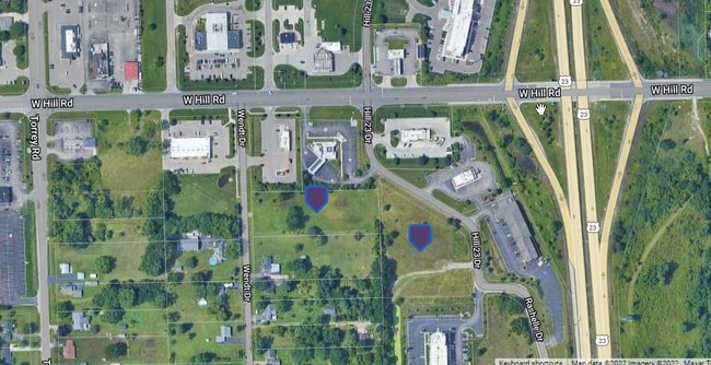
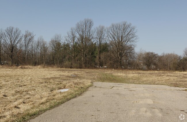
Property Record
6049 Wendt Dr, Flint, MI 48507
NEARBY LISTINGS FOR SALE OR LEASE
Property Detail
6049 Wendt Dr
15-11-100-027
S 175 FT OF N 523 FT OF E 500 FT OF NW 1/4 OF NW 1/4 SEC 11 T6N R6E 2.00 A
Commercialacreage
Genesee
X
Michigan
26049C0303D
2.01 AC
2024
Flint
2025
Detroit
012904
Flint, MI
DEMOGRAPHICS near 6049 Wendt Dr
1 Mile
3 Mile
5 Mile
2024 Total Population
1,608
25,628
81,553
2029 Population
1,610
24,988
80,154
Pop Growth 2024-2029
+ 0.12%
(2.50%)
(1.72%)
Average Age
44
41
40
2024 Total Households
685
11,159
34,377
HH Growth 2024-2029
0.00%
(2.62%)
(1.81%)
Median Household Inc
$72,651
$58,497
$48,071
Avg Household Size
2.30
2.20
2.30
2024 Avg HH Vehicles
2.00
2.00
2.00
Median Home Value
$169,865
$157,715
$130,485
Median Year Built
1974
1973
1966
Nearby Places
Map Layers
Map Styles
 Street
 Aerial
- Restaurants
- Banks
- Shops
- Fitness
- Groceries
PUBLIC TRANSPORTATION
COMMUTER RAIL
Flint Amtrak Station (Blue Water - Amtrak)
DRIVE
WALK
Distance
Flint Amtrak Station (Blue Water - Amtrak)
12 min
8.1 mi
AIRPORT
Bishop International
DRIVE
WALK
Distance
Bishop International
13 min
3.1 mi
Freight Ports
Port of Toledo
DRIVE
WALK
Distance
Port of Toledo
127 min
107.9 mi
SALE & LEASE HISTORY
LISTING DATE
SALE/LEASE

Sep 24, 2016
For Sale
Nov 03, 2017
For Sale
Mar 16, 2017
For Sale
Aug 04, 2022
For Sale
Nearby Properties
Address
Land Use
TOTAL SIZE
Lot Size
Zoning
Address
Land Use
TOTAL SIZE
Lot Size
Zoning
381,509 SF
371.45 AC
PC
Address
Land Use
TOTAL SIZE
Lot Size
Zoning
331,630 SF
63.88 AC
MDM
Address
Land Use
TOTAL SIZE
Lot Size
Zoning
Address
Land Use
TOTAL SIZE
Lot Size
Zoning
295,620 SF
25.62 AC
MDM
Address
Land Use
TOTAL SIZE
Lot Size
Zoning
911,140 SF
Address
Land Use
TOTAL SIZE
Lot Size
Zoning
260,000 SF
15.55 AC
PC
Address
Land Use
TOTAL SIZE
Lot Size
Zoning
120,487 SF
5.81 AC
PRC
Address
Land Use
TOTAL SIZE
Lot Size
Zoning
223,683 SF
24.88 AC
MDM
Address
Land Use
TOTAL SIZE
Lot Size
Zoning
315,700 SF
38.97 AC
RM-2
Address
Land Use
TOTAL SIZE
Lot Size
Zoning
401,680 SF
20.41 AC
PC
Address
Land Use
TOTAL SIZE
Lot Size
Zoning
65,746 SF
3.97 AC
C-4
Address
Land Use
TOTAL SIZE
Lot Size
Zoning
Address
Land Use
TOTAL SIZE
Lot Size
Zoning
45,204 SF
6.43 AC
M-M
Address
Land Use
TOTAL SIZE
Lot Size
Zoning
104,040 SF
17.02 AC
MDM
Address
Land Use
TOTAL SIZE
Lot Size
Zoning
406,416 SF
21.10 AC
PC
Address
Land Use
TOTAL SIZE
Lot Size
Zoning
75,536 SF
8.97 AC
PRC
Address
Land Use
TOTAL SIZE
Lot Size
Zoning
69,232 SF
2.75 AC
C-3A
Address
Land Use
TOTAL SIZE
Lot Size
Zoning
131,682 SF
11.51 AC
MDM
Address
Land Use
TOTAL SIZE
Lot Size
Zoning
100,000 SF
Address
Land Use
TOTAL SIZE
Lot Size
Zoning
15.19 AC
M-M
Address
Land Use
TOTAL SIZE
Lot Size
Zoning
58,648 SF
5.80 AC
OS
Address
Land Use
TOTAL SIZE
Lot Size
Zoning
100,750 SF
Address
Land Use
TOTAL SIZE
Lot Size
Zoning
460,000 SF
51.12 AC
PC
Address
Land Use
TOTAL SIZE
Lot Size
Zoning
118,750 SF
21.26 AC
C-3A
Address
Land Use
TOTAL SIZE
Lot Size
Zoning
38,289 SF
6.93 AC
C-3A
Address
Land Use
TOTAL SIZE
Lot Size
Zoning
64,150 SF
3.64 AC
PRC
Address
Land Use
TOTAL SIZE
Lot Size
Zoning
41,508 SF
5.27 AC
OS
Address
Land Use
TOTAL SIZE
Lot Size
Zoning
28,896 SF
7.47 AC
M-M
Address
Land Use
TOTAL SIZE
Lot Size
Zoning
3,355 SF
59.06 AC
M-3
Address
Land Use
TOTAL SIZE
Lot Size
Zoning
94,280 SF
48.79 AC
The World's #1 Commercial Real Estate Marketplace
Connect with us
© 2025 CoStar Group
The information above has been obtained from sources believed reliable. While we do not doubt its accuracy we have not verified it and make no guarantee, warranty or representation about it. It is your responsibility to independently confirm its accuracy and completeness. Any projections, opinions, assumptions, or estimates used are for example only and do not represent the current or future performance of the property. The value of this transaction to you depends on tax and other factors which should be evaluated by your tax, financial, and legal advisors. You and your advisors should conduct a careful, independent investigation of the property to determine to your satisfaction the suitability of the property for your needs.