Property Record
605 E 30Th St, Buena Vista, VA 24416

Property Detail
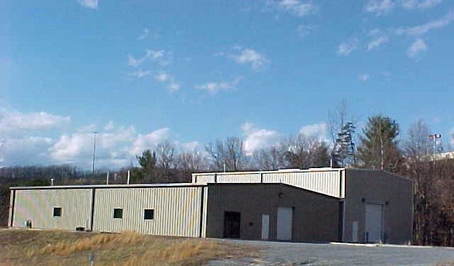
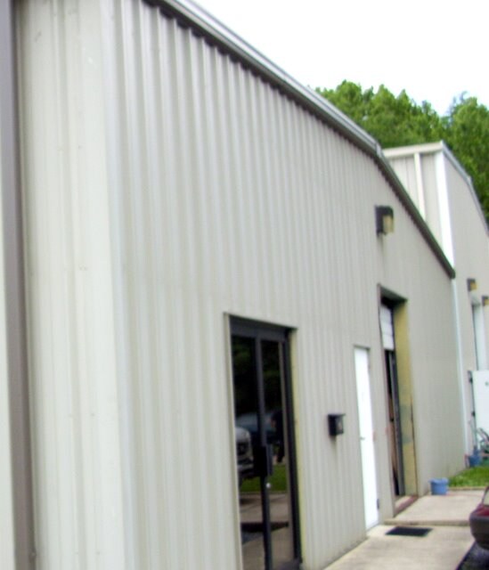
605 E 30Th St
Apartment
90-(4)-2.859 ACRES 136 759 PT OF F30 PARCEL B&C 605 E 30TH STREET 100000512
GM
Buena Vista City
A Areas with a 1% annual chance of flooding and a 26% chance of flooding over the life of a 30-year mortgage.
Virginia
2025
3 AC
2025
Virginia Shenandoah Valley Regional
930602
Other Market Areas
9,573 SF
20- A- - - 5
NEARBY LISTINGS FOR SALE OR LEASE
DEMOGRAPHICS near 605 E 30Th St
1 mile
3 mile
5 mile
2025 Total Population
2,893
7,898
9,617
2030 Population
2,898
7,845
9,545
Pop Growth 2025-2030
+ 0.17%
(0.67%)
(0.75%)
Average Age
38
41
42
2025 Total Households
1,017
3,108
3,833
HH Growth 2025-2030
+ 0.20%
(0.71%)
(0.78%)
Median Household Inc
$51,840
$54,278
$54,718
Avg Household Size
2.40
2.30
2.30
2025 Avg HH Vehicles
2.00
2.00
2.00
Median Home Value
$184,444
$185,713
$200,310
Median Year Built
1975
1973
1974
Nearby Places
Map Layers
Map Styles
 Street
 Aerial
Layers
 Traffic
 Biking
Places
Listings with unknown addresses are not visible on the map
- Restaurants
- Banks
- Shops
- Fitness
- Groceries
PUBLIC TRANSPORTATION
AIRPORT
Lynchburg Regional/Preston Glenn Field
Drive
Walk
Distance
Lynchburg Regional/Preston Glenn Field
59 min
42.5 mi
Freight Ports
Virginia Port Authority - Richmond
Drive
Walk
Distance
Virginia Port Authority - Richmond
168 min
126.3 mi
Nearby Properties
Address
Land Use
TOTAL SIZE
Lot Size
Zoning
Address
Land Use
TOTAL SIZE
Lot Size
Zoning
55,954 SF
INST
Address
Land Use
TOTAL SIZE
Lot Size
Zoning
285,942 SF
2.30 AC
R-3
Address
Land Use
TOTAL SIZE
Lot Size
Zoning
52,560 SF
INST
Address
Land Use
TOTAL SIZE
Lot Size
Zoning
15,810 SF
17 AC
MXR
Address
Land Use
TOTAL SIZE
Lot Size
Zoning
201,293 SF
LM
Address
Land Use
TOTAL SIZE
Lot Size
Zoning
263,226 SF
31 AC
R-2
Address
Land Use
TOTAL SIZE
Lot Size
Zoning
21,372 SF
0.29 AC
R2
Address
Land Use
TOTAL SIZE
Lot Size
Zoning
37,327 SF
3.44 AC
R3
Address
Land Use
TOTAL SIZE
Lot Size
Zoning
36,016 SF
6.80 AC
C-1
Address
Land Use
TOTAL SIZE
Lot Size
Zoning
30,424 SF
2.42 AC
B-1
Address
Land Use
TOTAL SIZE
Lot Size
Zoning
44,491 SF
5 AC
MXB
Address
Land Use
TOTAL SIZE
Lot Size
Zoning
11,946 SF
R3
Address
Land Use
TOTAL SIZE
Lot Size
Zoning
15,348 SF
3 AC
R-2
Address
Land Use
TOTAL SIZE
Lot Size
Zoning
104,900 SF
19 AC
GM
Address
Land Use
TOTAL SIZE
Lot Size
Zoning
56,224 SF
6 AC
R-2
Address
Land Use
TOTAL SIZE
Lot Size
Zoning
174,231 SF
13 AC
GM
Address
Land Use
TOTAL SIZE
Lot Size
Zoning
24,076 SF
0.43 AC
INST
Address
Land Use
TOTAL SIZE
Lot Size
Zoning
3,996 SF
6 AC
R-3
Address
Land Use
TOTAL SIZE
Lot Size
Zoning
118.16 AC
AT
Address
Land Use
TOTAL SIZE
Lot Size
Zoning
19,491 SF
3 AC
R2
Address
Land Use
TOTAL SIZE
Lot Size
Zoning
136.28 AC
MXRH
Address
Land Use
TOTAL SIZE
Lot Size
Zoning
20,892 SF
1.38 AC
B-1
Address
Land Use
TOTAL SIZE
Lot Size
Zoning
172,875 SF
20 AC
LM
Address
Land Use
TOTAL SIZE
Lot Size
Zoning
22,372 SF
0.29 AC
MB
Address
Land Use
TOTAL SIZE
Lot Size
Zoning
22,604 SF
0.43 AC
R3
Address
Land Use
TOTAL SIZE
Lot Size
Zoning
22,213 SF
0.43 AC
R3
Address
Land Use
TOTAL SIZE
Lot Size
Zoning
5,072 SF
0.43 AC
R-3
Address
Land Use
TOTAL SIZE
Lot Size
Zoning
11 AC
LM
Address
Land Use
TOTAL SIZE
Lot Size
Zoning
14,981 SF
0.57 AC
MU
Address
Land Use
TOTAL SIZE
Lot Size
Zoning
9,892 SF
0.43 AC
R3
The World's #1 Commercial Real Estate Marketplace
Connect with us
© 2026 CoStar Group
The information above has been obtained from sources believed reliable. While we do not doubt its accuracy we have not verified it and make no guarantee, warranty or representation about it. It is your responsibility to independently confirm its accuracy and completeness. Any projections, opinions, assumptions, or estimates used are for example only and do not represent the current or future performance of the property. The value of this transaction to you depends on tax and other factors which should be evaluated by your tax, financial, and legal advisors. You and your advisors should conduct a careful, independent investigation of the property to determine to your satisfaction the suitability of the property for your needs.