Property Record
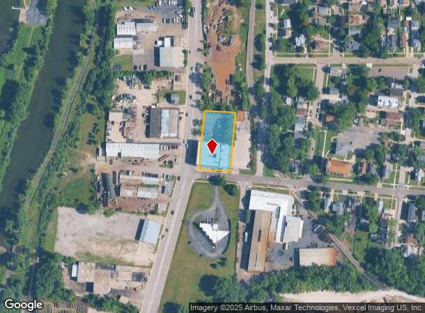
605 N Broadway, Aurora, IL 60505

NEARBY LISTINGS FOR SALE OR LEASE
Property Detail
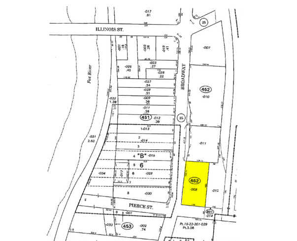
605 N Broadway
15-15-452-009
Subdivision
Industrialgeneral
PART SE 1/4 SEC 15-38-8 LOT DIMENSIONS: 250 X 135 APPROX LOT SQ FT 33750 SUBDIVISION: PART SE 1/4 SEC 15-38-8 RANGE CODE: 001
AE
Kane
17089C0343H
Illinois
2024
0.78 AC
2024
I-88 West
853300
Chicago
35,012 SF
Chicago-Naperville-Elgin, IL-IN-WI
DEMOGRAPHICS near 605 N Broadway
1 Mile
3 Mile
5 Mile
2024 Total Population
20,421
118,001
240,310
2029 Population
20,141
117,372
241,548
Pop Growth 2024-2029
(1.37%)
(0.53%)
+ 0.52%
Average Age
35
37
37
2024 Total Households
6,312
38,299
81,925
HH Growth 2024-2029
(1.19%)
(0.46%)
+ 0.55%
Median Household Inc
$56,822
$69,548
$83,332
Avg Household Size
3.10
2.90
2.80
2024 Avg HH Vehicles
2.00
2.00
2.00
Median Home Value
$155,427
$191,230
$237,506
Median Year Built
1948
1966
1986
Nearby Places
Map Layers
Map Styles
 Street
 Aerial
- Restaurants
- Banks
- Shops
- Fitness
- Groceries
PUBLIC TRANSPORTATION
COMMUTER RAIL
Aurora Station (Burlington Northern-Santa Fe Railway Line - Northeast Illinois Regional Commuter Railroad (Metra))
DRIVE
WALK
Distance
Aurora Station (Burlington Northern-Santa Fe Railway Line - Northeast Illinois Regional Commuter Railroad (Metra))
3 min
14 min
0.7 mi
Route 59 Station (Burlington Northern-Santa Fe Railway Line - Northeast Illinois Regional Commuter Railroad (Metra))
DRIVE
WALK
Distance
Route 59 Station (Burlington Northern-Santa Fe Railway Line - Northeast Illinois Regional Commuter Railroad (Metra))
14 min
6.3 mi
AIRPORT
Chicago O'Hare International
DRIVE
WALK
Distance
Chicago O'Hare International
67 min
35.2 mi
Chicago Midway International
DRIVE
WALK
Distance
Chicago Midway International
59 min
36.6 mi
Nearby Properties
Address
Land Use
TOTAL SIZE
Lot Size
Zoning
Address
Land Use
TOTAL SIZE
Lot Size
Zoning
41.29 AC
Address
Land Use
TOTAL SIZE
Lot Size
Zoning
27.18 AC
Address
Land Use
TOTAL SIZE
Lot Size
Zoning
10.62 AC
Address
Land Use
TOTAL SIZE
Lot Size
Zoning
Address
Land Use
TOTAL SIZE
Lot Size
Zoning
18.48 AC
Address
Land Use
TOTAL SIZE
Lot Size
Zoning
692,020 SF
33.90 AC
Address
Land Use
TOTAL SIZE
Lot Size
Zoning
Address
Land Use
TOTAL SIZE
Lot Size
Zoning
581,960 SF
17.63 AC
Address
Land Use
TOTAL SIZE
Lot Size
Zoning
20.56 AC
Address
Land Use
TOTAL SIZE
Lot Size
Zoning
12.80 AC
Address
Land Use
TOTAL SIZE
Lot Size
Zoning
622,072 SF
6.04 AC
Address
Land Use
TOTAL SIZE
Lot Size
Zoning
521,922 SF
19.87 AC
Address
Land Use
TOTAL SIZE
Lot Size
Zoning
Address
Land Use
TOTAL SIZE
Lot Size
Zoning
607,706 SF
16.55 AC
Address
Land Use
TOTAL SIZE
Lot Size
Zoning
25.07 AC
Address
Land Use
TOTAL SIZE
Lot Size
Zoning
11.79 AC
Address
Land Use
TOTAL SIZE
Lot Size
Zoning
320,874 SF
1.49 AC
Address
Land Use
TOTAL SIZE
Lot Size
Zoning
Address
Land Use
TOTAL SIZE
Lot Size
Zoning
383,948 SF
17.92 AC
Address
Land Use
TOTAL SIZE
Lot Size
Zoning
17.42 AC
Address
Land Use
TOTAL SIZE
Lot Size
Zoning
317,815 SF
21.29 AC
Address
Land Use
TOTAL SIZE
Lot Size
Zoning
173,240 SF
0.90 AC
Address
Land Use
TOTAL SIZE
Lot Size
Zoning
100,340 SF
1.80 AC
Address
Land Use
TOTAL SIZE
Lot Size
Zoning
289,366 SF
14.53 AC
Address
Land Use
TOTAL SIZE
Lot Size
Zoning
73,880 SF
0.75 AC
Address
Land Use
TOTAL SIZE
Lot Size
Zoning
Address
Land Use
TOTAL SIZE
Lot Size
Zoning
181,268 SF
7.62 AC
Address
Land Use
TOTAL SIZE
Lot Size
Zoning
28.95 AC
Address
Land Use
TOTAL SIZE
Lot Size
Zoning
136,900 SF
3.63 AC
Address
Land Use
TOTAL SIZE
Lot Size
Zoning
21.80 AC
The World's #1 Commercial Real Estate Marketplace
Connect with us
© 2025 CoStar Group
The information above has been obtained from sources believed reliable. While we do not doubt its accuracy we have not verified it and make no guarantee, warranty or representation about it. It is your responsibility to independently confirm its accuracy and completeness. Any projections, opinions, assumptions, or estimates used are for example only and do not represent the current or future performance of the property. The value of this transaction to you depends on tax and other factors which should be evaluated by your tax, financial, and legal advisors. You and your advisors should conduct a careful, independent investigation of the property to determine to your satisfaction the suitability of the property for your needs.