Property Record
605 N Main St, Robersonville, NC 27871

NEARBY LISTINGS FOR SALE OR LEASE
-
-
View all Robersonville listings for sale on LoopNet.com
Property Detail
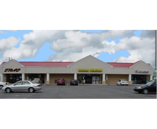
605 N Main St
0703216
W M Green Property
Stripcommercialcenter
STORES 605 N MAIN ST
X
Martin
3720570600J
North Carolina
2025
4.27 AC
2025
North Carolina Northeast Area
970600
Other Market Areas
11,520 SF
DEMOGRAPHICS near 605 N Main St
1 Mile
3 Mile
5 Mile
2024 Total Population
701
1,612
2,741
2029 Population
633
1,464
2,526
Pop Growth 2024-2029
(9.70%)
(9.18%)
(7.84%)
Average Age
46
45
45
2024 Total Households
308
700
1,178
HH Growth 2024-2029
(9.42%)
(9.14%)
(7.81%)
Median Household Inc
$33,610
$35,143
$38,322
Avg Household Size
2.30
2.30
2.30
2024 Avg HH Vehicles
2.00
2.00
2.00
Median Home Value
$83,897
$83,882
$81,198
Median Year Built
1971
1971
1972
Nearby Places
Map Layers
Map Styles
 Street
 Aerial
- Restaurants
- Banks
- Shops
- Fitness
- Groceries
PUBLIC TRANSPORTATION
AIRPORT
Pitt-Greenville
DRIVE
WALK
Distance
Pitt-Greenville
30 min
19.1 mi
Nearby Properties
Address
Land Use
TOTAL SIZE
Lot Size
Zoning
Address
Land Use
TOTAL SIZE
Lot Size
Zoning
19,188 SF
51.14 AC
C
Address
Land Use
TOTAL SIZE
Lot Size
Zoning
48,892 SF
17.42 AC
Address
Land Use
TOTAL SIZE
Lot Size
Zoning
49,168 SF
21.77 AC
C
Address
Land Use
TOTAL SIZE
Lot Size
Zoning
206,369 SF
12.98 AC
OI
Address
Land Use
TOTAL SIZE
Lot Size
Zoning
32,294 SF
5.64 AC
Address
Land Use
TOTAL SIZE
Lot Size
Zoning
1.79 AC
Address
Land Use
TOTAL SIZE
Lot Size
Zoning
146,164 SF
30.20 AC
Address
Land Use
TOTAL SIZE
Lot Size
Zoning
3,991 SF
1.86 AC
Address
Land Use
TOTAL SIZE
Lot Size
Zoning
10,126 SF
7.36 AC
R15
Address
Land Use
TOTAL SIZE
Lot Size
Zoning
8.73 AC
C
Address
Land Use
TOTAL SIZE
Lot Size
Zoning
1.82 AC
Address
Land Use
TOTAL SIZE
Lot Size
Zoning
3,516 SF
3.69 AC
Address
Land Use
TOTAL SIZE
Lot Size
Zoning
3,404 SF
1.33 AC
Address
Land Use
TOTAL SIZE
Lot Size
Zoning
3,144 SF
0.86 AC
CB
Address
Land Use
TOTAL SIZE
Lot Size
Zoning
80,400 SF
17.55 AC
I
Address
Land Use
TOTAL SIZE
Lot Size
Zoning
4,375 SF
3.02 AC
C
Address
Land Use
TOTAL SIZE
Lot Size
Zoning
1.60 AC
Address
Land Use
TOTAL SIZE
Lot Size
Zoning
0.17 AC
Address
Land Use
TOTAL SIZE
Lot Size
Zoning
23.64 AC
C
Address
Land Use
TOTAL SIZE
Lot Size
Zoning
1,752 SF
102 AC
A
Address
Land Use
TOTAL SIZE
Lot Size
Zoning
4,366 SF
71.46 AC
Address
Land Use
TOTAL SIZE
Lot Size
Zoning
2,924 SF
1.70 AC
Address
Land Use
TOTAL SIZE
Lot Size
Zoning
339.87 AC
A
Address
Land Use
TOTAL SIZE
Lot Size
Zoning
21,272 SF
3.03 AC
HC
Address
Land Use
TOTAL SIZE
Lot Size
Zoning
64,509 SF
11.13 AC
M1
Address
Land Use
TOTAL SIZE
Lot Size
Zoning
4,480 SF
13.30 AC
C
Address
Land Use
TOTAL SIZE
Lot Size
Zoning
223.27 AC
A
Address
Land Use
TOTAL SIZE
Lot Size
Zoning
7,770 SF
3.61 AC
Address
Land Use
TOTAL SIZE
Lot Size
Zoning
2,410 SF
273.88 AC
A
The World's #1 Commercial Real Estate Marketplace
Connect with us
© 2025 CoStar Group
The information above has been obtained from sources believed reliable. While we do not doubt its accuracy we have not verified it and make no guarantee, warranty or representation about it. It is your responsibility to independently confirm its accuracy and completeness. Any projections, opinions, assumptions, or estimates used are for example only and do not represent the current or future performance of the property. The value of this transaction to you depends on tax and other factors which should be evaluated by your tax, financial, and legal advisors. You and your advisors should conduct a careful, independent investigation of the property to determine to your satisfaction the suitability of the property for your needs.