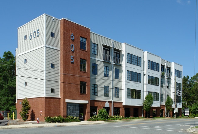
Property Record
605 W Main St, Carrboro, NC 27510
This Property Is For Sale
NEARBY LISTINGS FOR SALE OR LEASE
Property Detail
605 W Main St
Durham-Chapel Hill, NC
Bracks Mobile Home Court
9778672475.001
Orange
Condominium
North Carolina
X
0.53 AC
3710977800K
Orange County
976 SF
Raleigh/Durham
DEMOGRAPHICS near 605 W Main St
1 Mile
3 Mile
5 Mile
2024 Total Population
14,605
59,411
100,132
2029 Population
13,570
55,441
94,625
Pop Growth 2024-2029
(7.09%)
(6.68%)
(5.50%)
Average Age
36
34
37
2024 Total Households
6,963
21,556
38,758
HH Growth 2024-2029
(7.17%)
(7.71%)
(5.86%)
Median Household Inc
$56,960
$69,137
$84,720
Avg Household Size
2.00
2.30
2.30
2024 Avg HH Vehicles
2.00
2.00
2.00
Median Home Value
$376,706
$473,460
$468,107
Median Year Built
1981
1985
1988
Nearby Places
- Restaurants
- Banks
- Shops
- Fitness
- Groceries
PUBLIC TRANSPORTATION
AIRPORT
Raleigh-Durham International
DRIVE
WALK
Distance
Raleigh-Durham International
33 min
20.2 mi
Freight Ports
Port of Wilmington
DRIVE
WALK
Distance
Port of Wilmington
193 min
164.3 mi
Nearby Properties
Address
Land Use
TOTAL SIZE
Lot Size
Zoning
Address
Land Use
TOTAL SIZE
Lot Size
Zoning
215,860 SF
12.28 AC
Address
Land Use
TOTAL SIZE
Lot Size
Zoning
264,710 SF
32.50 AC
R1
Address
Land Use
TOTAL SIZE
Lot Size
Zoning
208,406 SF
120.44 AC
R1
Address
Land Use
TOTAL SIZE
Lot Size
Zoning
4,128 SF
678.68 AC
R1
Address
Land Use
TOTAL SIZE
Lot Size
Zoning
81,191 SF
12.33 AC
OI4
Address
Land Use
TOTAL SIZE
Lot Size
Zoning
55,318 SF
9.05 AC
R4
Address
Land Use
TOTAL SIZE
Lot Size
Zoning
134,448 SF
59.23 AC
Address
Land Use
TOTAL SIZE
Lot Size
Zoning
119,585 SF
62.30 AC
Address
Land Use
TOTAL SIZE
Lot Size
Zoning
21,078 SF
227.43 AC
OI3R2
Address
Land Use
TOTAL SIZE
Lot Size
Zoning
26,328 SF
13.86 AC
OR3
Address
Land Use
TOTAL SIZE
Lot Size
Zoning
361,420 SF
1.68 AC
Address
Land Use
TOTAL SIZE
Lot Size
Zoning
85,652 SF
16.49 AC
R1R5
Address
Land Use
TOTAL SIZE
Lot Size
Zoning
17,640 SF
11.51 AC
R4R5C
Address
Land Use
TOTAL SIZE
Lot Size
Zoning
119,517 SF
28.28 AC
R20
Address
Land Use
TOTAL SIZE
Lot Size
Zoning
13,912 SF
18.61 AC
NCR5
Address
Land Use
TOTAL SIZE
Lot Size
Zoning
24,820 SF
1 AC
Address
Land Use
TOTAL SIZE
Lot Size
Zoning
143,750 SF
1.32 AC
OI3OI4
Address
Land Use
TOTAL SIZE
Lot Size
Zoning
174,922 SF
4.59 AC
OI4
Address
Land Use
TOTAL SIZE
Lot Size
Zoning
15,916 SF
46.02 AC
R10RSIR
Address
Land Use
TOTAL SIZE
Lot Size
Zoning
12,328 SF
16.37 AC
R75
Address
Land Use
TOTAL SIZE
Lot Size
Zoning
78,028 SF
32.60 AC
Address
Land Use
TOTAL SIZE
Lot Size
Zoning
22,328 SF
19.48 AC
Address
Land Use
TOTAL SIZE
Lot Size
Zoning
82,064 SF
1.41 AC
Address
Land Use
TOTAL SIZE
Lot Size
Zoning
42,628 SF
6.12 AC
Address
Land Use
TOTAL SIZE
Lot Size
Zoning
45,320 SF
0.66 AC
TC1TC2
Address
Land Use
TOTAL SIZE
Lot Size
Zoning
109,142 SF
13.16 AC
Address
Land Use
TOTAL SIZE
Lot Size
Zoning
71,856 SF
20.37 AC
R10R3
Address
Land Use
TOTAL SIZE
Lot Size
Zoning
50,228 SF
34.85 AC
R1R5
Address
Land Use
TOTAL SIZE
Lot Size
Zoning
12,014 SF
10.38 AC
R75
Address
Land Use
TOTAL SIZE
Lot Size
Zoning
48,690 SF
15.69 AC
OR3R75
The World's #1 Commercial Real Estate Marketplace
Connect with us
© 2025 CoStar Group
The information above has been obtained from sources believed reliable. While we do not doubt its accuracy we have not verified it and make no guarantee, warranty or representation about it. It is your responsibility to independently confirm its accuracy and completeness. Any projections, opinions, assumptions, or estimates used are for example only and do not represent the current or future performance of the property. The value of this transaction to you depends on tax and other factors which should be evaluated by your tax, financial, and legal advisors. You and your advisors should conduct a careful, independent investigation of the property to determine to your satisfaction the suitability of the property for your needs.