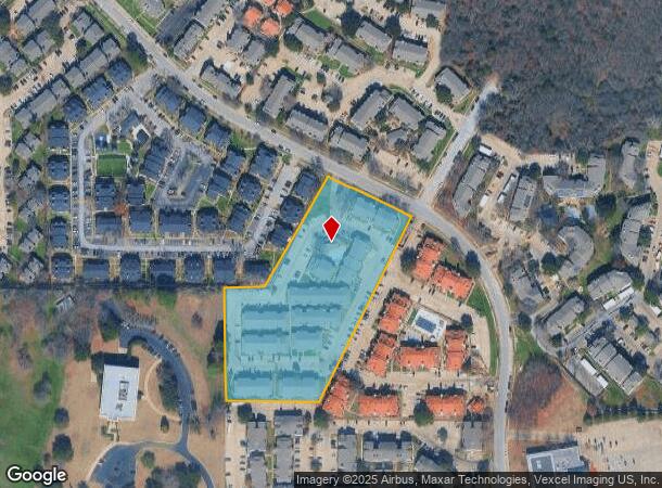
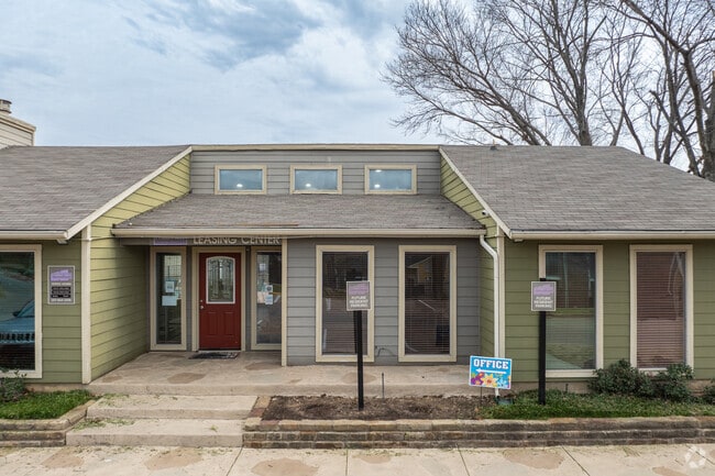
Property Record
6050 Oakland Hills Dr, Fort Worth, TX 76112


NEARBY LISTINGS FOR SALE OR LEASE
-
-
View all Fort Worth listings for sale on LoopNet.com
Property Detail
6050 Oakland Hills Dr
Dallas-Fort Worth-Arlington, TX
Woodhaven Cntry Club Estates
04972880
WOODHAVEN CNTRY CLUB ESTATES BLOCK 5 LOT 6R
Multifamilydwelling
Tarrant
X
Texas
48439C0215L
6r
2024
5 AC
2025
Woodhaven
106520
Dallas/Ft Worth
102,700 SF
DEMOGRAPHICS near 6050 Oakland Hills Dr
1 Mile
3 Mile
5 Mile
2024 Total Population
15,555
74,411
234,086
2029 Population
16,636
79,009
247,413
Pop Growth 2024-2029
+ 6.95%
+ 6.18%
+ 5.69%
Average Age
35
37
37
2024 Total Households
6,798
28,136
83,389
HH Growth 2024-2029
+ 7.05%
+ 6.29%
+ 5.75%
Median Household Inc
$42,122
$51,127
$54,672
Avg Household Size
2.30
2.60
2.70
2024 Avg HH Vehicles
2.00
2.00
2.00
Median Home Value
$245,833
$201,361
$207,169
Median Year Built
1980
1976
1973
Nearby Places
Map Layers
Map Styles
 Street
 Aerial
- Restaurants
- Banks
- Shops
- Fitness
- Groceries
PUBLIC TRANSPORTATION
COMMUTER RAIL
Richland Hills (Trinity Railway Express - Dallas Area Rapid Transit (DART))
DRIVE
WALK
Distance
Richland Hills (Trinity Railway Express - Dallas Area Rapid Transit (DART))
8 min
3.4 mi
Trinity Lakes Station (TRINITY RAILWAY - Dallas Area Rapid Transit (DART))
DRIVE
WALK
Distance
Trinity Lakes Station (TRINITY RAILWAY - Dallas Area Rapid Transit (DART))
9 min
4.5 mi
AIRPORT
Dallas-Fort Worth International
DRIVE
WALK
Distance
Dallas-Fort Worth International
29 min
20.4 mi
Dallas Love Field
DRIVE
WALK
Distance
Dallas Love Field
39 min
29.1 mi
Freight Ports
Port of Shreveport
DRIVE
WALK
Distance
Port of Shreveport
242 min
221.9 mi
Nearby Properties
Address
Land Use
TOTAL SIZE
Lot Size
Zoning
Address
Land Use
TOTAL SIZE
Lot Size
Zoning
221,946 SF
31.17 AC
Address
Land Use
TOTAL SIZE
Lot Size
Zoning
163,000 SF
12.36 AC
Address
Land Use
TOTAL SIZE
Lot Size
Zoning
526,195 SF
40.84 AC
Address
Land Use
TOTAL SIZE
Lot Size
Zoning
171,769 SF
4.96 AC
Address
Land Use
TOTAL SIZE
Lot Size
Zoning
306,524 SF
24.92 AC
Address
Land Use
TOTAL SIZE
Lot Size
Zoning
131,582 SF
10.61 AC
Address
Land Use
TOTAL SIZE
Lot Size
Zoning
228,667 SF
12.17 AC
Address
Land Use
TOTAL SIZE
Lot Size
Zoning
125,838 SF
12.38 AC
Address
Land Use
TOTAL SIZE
Lot Size
Zoning
176,735 SF
10.62 AC
Address
Land Use
TOTAL SIZE
Lot Size
Zoning
197,881 SF
9.98 AC
Address
Land Use
TOTAL SIZE
Lot Size
Zoning
128,208 SF
43.67 AC
Address
Land Use
TOTAL SIZE
Lot Size
Zoning
300,000 SF
16.60 AC
Address
Land Use
TOTAL SIZE
Lot Size
Zoning
187,684 SF
9.20 AC
Address
Land Use
TOTAL SIZE
Lot Size
Zoning
222,978 SF
12.46 AC
Address
Land Use
TOTAL SIZE
Lot Size
Zoning
343,452 SF
30.29 AC
Address
Land Use
TOTAL SIZE
Lot Size
Zoning
220,922 SF
15.32 AC
Address
Land Use
TOTAL SIZE
Lot Size
Zoning
204,636 SF
9.98 AC
Address
Land Use
TOTAL SIZE
Lot Size
Zoning
200,081 SF
10.38 AC
Address
Land Use
TOTAL SIZE
Lot Size
Zoning
198,256 SF
7.96 AC
Address
Land Use
TOTAL SIZE
Lot Size
Zoning
196,098 SF
7.95 AC
Address
Land Use
TOTAL SIZE
Lot Size
Zoning
209,157 SF
21.89 AC
Address
Land Use
TOTAL SIZE
Lot Size
Zoning
185,804 SF
9.73 AC
Address
Land Use
TOTAL SIZE
Lot Size
Zoning
91,912 SF
10.10 AC
Address
Land Use
TOTAL SIZE
Lot Size
Zoning
485,896 SF
26.89 AC
Address
Land Use
TOTAL SIZE
Lot Size
Zoning
1,880 SF
36.03 AC
Address
Land Use
TOTAL SIZE
Lot Size
Zoning
178,923 SF
10.67 AC
Address
Land Use
TOTAL SIZE
Lot Size
Zoning
178,773 SF
10 AC
Address
Land Use
TOTAL SIZE
Lot Size
Zoning
208,085 SF
12 AC
Address
Land Use
TOTAL SIZE
Lot Size
Zoning
161,934 SF
9.89 AC
Address
Land Use
TOTAL SIZE
Lot Size
Zoning
63,994 SF
8.15 AC
The World's #1 Commercial Real Estate Marketplace
Connect with us
© 2026 CoStar Group
The information above has been obtained from sources believed reliable. While we do not doubt its accuracy we have not verified it and make no guarantee, warranty or representation about it. It is your responsibility to independently confirm its accuracy and completeness. Any projections, opinions, assumptions, or estimates used are for example only and do not represent the current or future performance of the property. The value of this transaction to you depends on tax and other factors which should be evaluated by your tax, financial, and legal advisors. You and your advisors should conduct a careful, independent investigation of the property to determine to your satisfaction the suitability of the property for your needs.