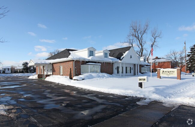
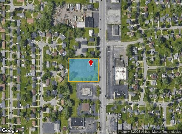
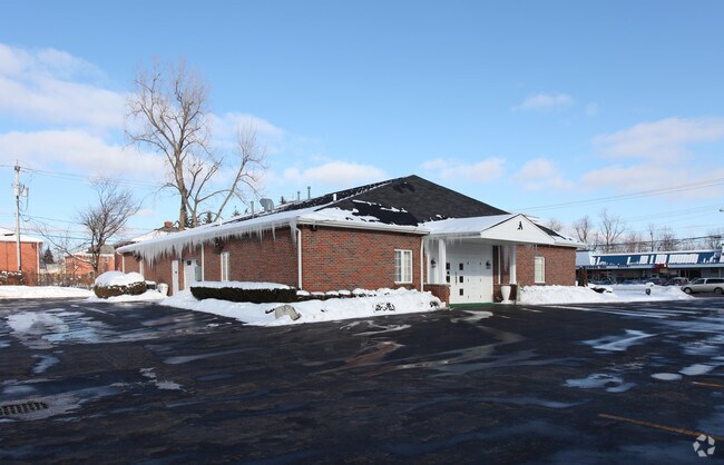
Property Record
6050 Transit Rd, Depew, NY 14043
NEARBY LISTINGS FOR SALE OR LEASE
Property Detail
6050 Transit Rd
143003-093-170-0010-019-121
525' N OF FRENCH RD
Funeralhome
Erie
X
New York
36029C0237H
19.121
2025
1.45 AC
2024
East
009702
Buffalo/Niagara Falls
5,142 SF
Buffalo-Cheektowaga-Niagara Falls, NY
DEMOGRAPHICS near 6050 Transit Rd
1 Mile
3 Mile
5 Mile
2024 Total Population
10,700
56,652
163,458
2029 Population
10,617
56,184
162,427
Pop Growth 2024-2029
(0.78%)
(0.83%)
(0.63%)
Average Age
43
43
44
2024 Total Households
4,702
25,107
72,119
HH Growth 2024-2029
(0.87%)
(0.94%)
(0.70%)
Median Household Inc
$71,777
$70,017
$71,522
Avg Household Size
2.20
2.20
2.20
2024 Avg HH Vehicles
2.00
2.00
2.00
Median Home Value
$155,465
$172,302
$186,671
Median Year Built
1963
1964
1964
Nearby Places
- Restaurants
- Banks
- Shops
- Fitness
- Groceries
PUBLIC TRANSPORTATION
COMMUTER RAIL
DRIVE
WALK
Distance
5 min
2.2 mi
DRIVE
WALK
Distance
7 min
2.7 mi
AIRPORT
Buffalo Niagara International
DRIVE
WALK
Distance
Buffalo Niagara International
8 min
3.6 mi
Niagara Falls International
DRIVE
WALK
Distance
Niagara Falls International
37 min
21.0 mi
Nearby Properties
Address
Land Use
TOTAL SIZE
Lot Size
Zoning
Address
Land Use
TOTAL SIZE
Lot Size
Zoning
462,256 SF
568.62 AC
05C
Address
Land Use
TOTAL SIZE
Lot Size
Zoning
82,802 SF
12.80 AC
05C
Address
Land Use
TOTAL SIZE
Lot Size
Zoning
82.29 AC
05C
Address
Land Use
TOTAL SIZE
Lot Size
Zoning
216,724 SF
66.09 AC
05C
Address
Land Use
TOTAL SIZE
Lot Size
Zoning
12,576 SF
18.15 AC
Address
Land Use
TOTAL SIZE
Lot Size
Zoning
8,296 SF
16.60 AC
Address
Land Use
TOTAL SIZE
Lot Size
Zoning
172,001 SF
23.49 AC
Address
Land Use
TOTAL SIZE
Lot Size
Zoning
722,642 SF
46.80 AC
05C
Address
Land Use
TOTAL SIZE
Lot Size
Zoning
6,618 SF
36.08 AC
MFMU
Address
Land Use
TOTAL SIZE
Lot Size
Zoning
140,786 SF
11.88 AC
05C
Address
Land Use
TOTAL SIZE
Lot Size
Zoning
19,558 SF
11.07 AC
Address
Land Use
TOTAL SIZE
Lot Size
Zoning
19,640 SF
13.34 AC
00000
Address
Land Use
TOTAL SIZE
Lot Size
Zoning
320,945 SF
62.80 AC
RES
Address
Land Use
TOTAL SIZE
Lot Size
Zoning
8,347 SF
14.04 AC
Address
Land Use
TOTAL SIZE
Lot Size
Zoning
268,620 SF
70.25 AC
GI
Address
Land Use
TOTAL SIZE
Lot Size
Zoning
Address
Land Use
TOTAL SIZE
Lot Size
Zoning
175,542 SF
12.70 AC
05C
Address
Land Use
TOTAL SIZE
Lot Size
Zoning
119,040 SF
19.17 AC
Address
Land Use
TOTAL SIZE
Lot Size
Zoning
323,590 SF
7.43 AC
05C
Address
Land Use
TOTAL SIZE
Lot Size
Zoning
265,787 SF
21.40 AC
Address
Land Use
TOTAL SIZE
Lot Size
Zoning
150,539 SF
14.65 AC
05C
Address
Land Use
TOTAL SIZE
Lot Size
Zoning
1,760 SF
41.19 AC
05C
Address
Land Use
TOTAL SIZE
Lot Size
Zoning
Address
Land Use
TOTAL SIZE
Lot Size
Zoning
189,326 SF
17.10 AC
Address
Land Use
TOTAL SIZE
Lot Size
Zoning
2,170 SF
8.77 AC
05C
Address
Land Use
TOTAL SIZE
Lot Size
Zoning
466,043 SF
23.20 AC
05C
Address
Land Use
TOTAL SIZE
Lot Size
Zoning
71,739 SF
7.58 AC
Address
Land Use
TOTAL SIZE
Lot Size
Zoning
60,268 SF
5 AC
Address
Land Use
TOTAL SIZE
Lot Size
Zoning
400,760 SF
48.38 AC
05C
Address
Land Use
TOTAL SIZE
Lot Size
Zoning
176,610 SF
23.40 AC
The World's #1 Commercial Real Estate Marketplace
Connect with us
© 2025 CoStar Group
The information above has been obtained from sources believed reliable. While we do not doubt its accuracy we have not verified it and make no guarantee, warranty or representation about it. It is your responsibility to independently confirm its accuracy and completeness. Any projections, opinions, assumptions, or estimates used are for example only and do not represent the current or future performance of the property. The value of this transaction to you depends on tax and other factors which should be evaluated by your tax, financial, and legal advisors. You and your advisors should conduct a careful, independent investigation of the property to determine to your satisfaction the suitability of the property for your needs.