Property Record
6052 W State St, Boise, ID 83703
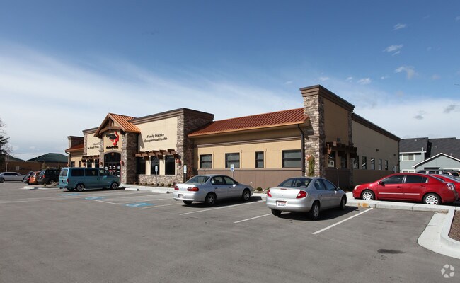

Property Detail
6052 W State St
R1739080165
LOT 16 BLK 01 EXC ROW DAVENPORT VILLAGE SUB #0160-B
Commercialbuilding
Ada
C-2D
Idaho
B and X Area of moderate flood hazard, usually the area between the limits of the 100-year and 500-year floods.
16
2025
1.33 AC
2025
North Boise
000306
Boise City/Nampa
13,295 SF
Boise City, ID
NEARBY LISTINGS FOR SALE OR LEASE
DEMOGRAPHICS near 6052 W State St
1 mile
3 mile
5 mile
2024 Total Population
11,227
76,810
195,381
2029 Population
11,662
80,165
204,673
Pop Growth 2024-2029
+ 3.87%
+ 4.37%
+ 4.76%
Average Age
44
43
41
2024 Total Households
5,229
32,879
81,657
HH Growth 2024-2029
+ 4.26%
+ 4.78%
+ 5.24%
Median Household Inc
$76,090
$80,268
$78,837
Avg Household Size
2.10
2.30
2.30
2024 Avg HH Vehicles
2.00
2.00
2.00
Median Home Value
$490,682
$479,134
$496,449
Median Year Built
1992
1988
1990
Nearby Places
Map Layers
Map Styles
 Street
 Aerial
Transit
 Traffic
 Biking
Places
Listings with unknown addresses are not visible on the map
- Restaurants
- Banks
- Shops
- Fitness
- Groceries
PUBLIC TRANSPORTATION
AIRPORT
Boise Air Trml/Gowen Field
Drive
Walk
Distance
Boise Air Trml/Gowen Field
23 min
9.9 mi
Nearby Properties
Address
Land Use
TOTAL SIZE
Lot Size
Zoning
Address
Land Use
TOTAL SIZE
Lot Size
Zoning
13.90 AC
R-2D
Address
Land Use
TOTAL SIZE
Lot Size
Zoning
386,225 SF
13.46 AC
C-4D/DA
Address
Land Use
TOTAL SIZE
Lot Size
Zoning
4.02 AC
C-2
Address
Land Use
TOTAL SIZE
Lot Size
Zoning
207,033 SF
10.67 AC
L-OD
Address
Land Use
TOTAL SIZE
Lot Size
Zoning
245,000 SF
12.28 AC
R-2D
Address
Land Use
TOTAL SIZE
Lot Size
Zoning
216,950 SF
9.03 AC
R-3D
Address
Land Use
TOTAL SIZE
Lot Size
Zoning
151,285 SF
9.54 AC
R-1C
Address
Land Use
TOTAL SIZE
Lot Size
Zoning
222,379 SF
1.37 AC
M
Address
Land Use
TOTAL SIZE
Lot Size
Zoning
150,584 SF
6.77 AC
M
Address
Land Use
TOTAL SIZE
Lot Size
Zoning
7.16 AC
C-2D
Address
Land Use
TOTAL SIZE
Lot Size
Zoning
203,635 SF
4.76 AC
L-OD
Address
Land Use
TOTAL SIZE
Lot Size
Zoning
176,494 SF
10.16 AC
R-1C
Address
Land Use
TOTAL SIZE
Lot Size
Zoning
167,603 SF
6.60 AC
C-2DA
Address
Land Use
TOTAL SIZE
Lot Size
Zoning
10.32 AC
C-2D
Address
Land Use
TOTAL SIZE
Lot Size
Zoning
124,286 SF
5 AC
R-3
Address
Land Use
TOTAL SIZE
Lot Size
Zoning
102,272 SF
7.18 AC
R-20
Address
Land Use
TOTAL SIZE
Lot Size
Zoning
92,243 SF
2.05 AC
R-3
Address
Land Use
TOTAL SIZE
Lot Size
Zoning
83,700 SF
6.48 AC
R-2
Address
Land Use
TOTAL SIZE
Lot Size
Zoning
204,033 SF
12.88 AC
C-1
Address
Land Use
TOTAL SIZE
Lot Size
Zoning
159,839 SF
16.94 AC
C-2
Address
Land Use
TOTAL SIZE
Lot Size
Zoning
132,534 SF
1.15 AC
ZC-243
Address
Land Use
TOTAL SIZE
Lot Size
Zoning
123,324 SF
2.22 AC
R-3D
Address
Land Use
TOTAL SIZE
Lot Size
Zoning
84,070 SF
4.22 AC
R-3D
Address
Land Use
TOTAL SIZE
Lot Size
Zoning
28,776 SF
3.30 AC
C-4D
Address
Land Use
TOTAL SIZE
Lot Size
Zoning
80,722 SF
4.59 AC
C-2D
Address
Land Use
TOTAL SIZE
Lot Size
Zoning
64,468 SF
1.65 AC
C-1D/DA
Address
Land Use
TOTAL SIZE
Lot Size
Zoning
63,476 SF
3.58 AC
R-2D
Address
Land Use
TOTAL SIZE
Lot Size
Zoning
111,478 SF
7.41 AC
ZC-243
Address
Land Use
TOTAL SIZE
Lot Size
Zoning
60,786 SF
3.73 AC
R-2
Address
Land Use
TOTAL SIZE
Lot Size
Zoning
30,144 SF
22.20 AC
R-3
The World's #1 Commercial Real Estate Marketplace
Connect with us
© 2026 CoStar Group
The information above has been obtained from sources believed reliable. While we do not doubt its accuracy we have not verified it and make no guarantee, warranty or representation about it. It is your responsibility to independently confirm its accuracy and completeness. Any projections, opinions, assumptions, or estimates used are for example only and do not represent the current or future performance of the property. The value of this transaction to you depends on tax and other factors which should be evaluated by your tax, financial, and legal advisors. You and your advisors should conduct a careful, independent investigation of the property to determine to your satisfaction the suitability of the property for your needs.