Property Record
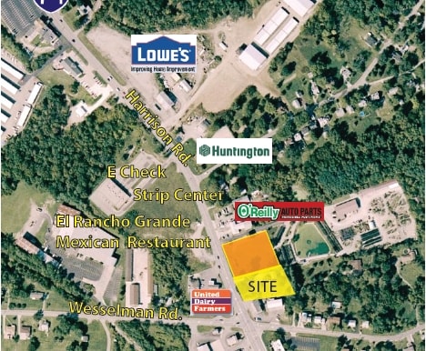
6054 Harrison Ave, Cincinnati, OH 45247


Property Detail
6054 Harrison Ave
550-0193-0041
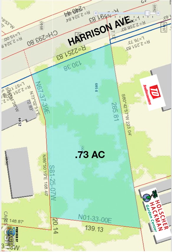
ES HARRISON AV 0.73 AC R2-T2-S23 SW
Residentialacreage
HAMILTON
E
Ohio
B and X Area of moderate flood hazard, usually the area between the limits of the 100-year and 500-year floods.
0.73 AC
2025
Forest Park/West
2025
Cincinnati/Dayton
020604
Cincinnati, OH-KY-IN
1,600 SF
NEARBY LISTINGS FOR SALE OR LEASE
-
-
No Photo
-
-
-
-
-
-
View all Cincinnati listings for sale on LoopNet.com
DEMOGRAPHICS near 6054 Harrison Ave
1 mile
3 mile
5 mile
2025 Total Population
4,558
57,870
164,505
2030 Population
4,561
57,660
165,183
Pop Growth 2025-2030
+ 0.07%
(0.36%)
+ 0.41%
Average Age
45
42
40
2025 Total Households
2,083
23,883
67,407
HH Growth 2025-2030
+ 0.10%
(0.36%)
+ 0.42%
Median Household Inc
$71,934
$77,237
$67,862
Avg Household Size
2.10
2.40
2.40
2025 Avg HH Vehicles
2.00
2.00
2.00
Median Home Value
$235,880
$232,207
$227,066
Median Year Built
1983
1969
1967
Nearby Places
Map Layers
Map Styles
 Street
 Aerial
Transit
 Traffic
 Biking
Places
Listings with unknown addresses are not visible on the map
- Restaurants
- Banks
- Shops
- Fitness
- Groceries
PUBLIC TRANSPORTATION
AIRPORT
Cincinnati/Northern Kentucky International
Drive
Walk
Distance
Cincinnati/Northern Kentucky International
43 min
26.8 mi
Freight Ports
Port of Toledo
Drive
Walk
Distance
Port of Toledo
244 min
208.8 mi
SALE & LEASE HISTORY
LISTING DATE
SALE/LEASE

Jun 15, 2023
For Sale
Nearby Properties
Address
Land Use
TOTAL SIZE
Lot Size
Zoning
Address
Land Use
TOTAL SIZE
Lot Size
Zoning
Address
Land Use
TOTAL SIZE
Lot Size
Zoning
5.38 AC
OO
Address
Land Use
TOTAL SIZE
Lot Size
Zoning
9.52 AC
B
Address
Land Use
TOTAL SIZE
Lot Size
Zoning
12.23 AC
Address
Land Use
TOTAL SIZE
Lot Size
Zoning
474 SF
9.59 AC
A
Address
Land Use
TOTAL SIZE
Lot Size
Zoning
Address
Land Use
TOTAL SIZE
Lot Size
Zoning
1,671 SF
21.48 AC
CCUP
Address
Land Use
TOTAL SIZE
Lot Size
Zoning
2,678 SF
8.76 AC
Address
Land Use
TOTAL SIZE
Lot Size
Zoning
6,620 SF
16.91 AC
Address
Land Use
TOTAL SIZE
Lot Size
Zoning
14.43 AC
Address
Land Use
TOTAL SIZE
Lot Size
Zoning
Address
Land Use
TOTAL SIZE
Lot Size
Zoning
4.68 AC
E
Address
Land Use
TOTAL SIZE
Lot Size
Zoning
29,084 SF
30.10 AC
DD
Address
Land Use
TOTAL SIZE
Lot Size
Zoning
360 SF
7.79 AC
F
Address
Land Use
TOTAL SIZE
Lot Size
Zoning
6,000 SF
11.92 AC
G
Address
Land Use
TOTAL SIZE
Lot Size
Zoning
8.57 AC
Address
Land Use
TOTAL SIZE
Lot Size
Zoning
18.30 AC
EE
Address
Land Use
TOTAL SIZE
Lot Size
Zoning
4.28 AC
OO
Address
Land Use
TOTAL SIZE
Lot Size
Zoning
60,751 SF
9.57 AC
C
Address
Land Use
TOTAL SIZE
Lot Size
Zoning
4.33 AC
Address
Land Use
TOTAL SIZE
Lot Size
Zoning
8,580 SF
19.31 AC
DD
Address
Land Use
TOTAL SIZE
Lot Size
Zoning
Address
Land Use
TOTAL SIZE
Lot Size
Zoning
6.91 AC
B
Address
Land Use
TOTAL SIZE
Lot Size
Zoning
3.04 AC
OO
Address
Land Use
TOTAL SIZE
Lot Size
Zoning
9.43 AC
CGA
Address
Land Use
TOTAL SIZE
Lot Size
Zoning
8.69 AC
EE
Address
Land Use
TOTAL SIZE
Lot Size
Zoning
160,718 SF
15.20 AC
FPUD
Address
Land Use
TOTAL SIZE
Lot Size
Zoning
Address
Land Use
TOTAL SIZE
Lot Size
Zoning
5.51 AC
F
Address
Land Use
TOTAL SIZE
Lot Size
Zoning
31.99 AC
B
The World's #1 Commercial Real Estate Marketplace
Connect with us
© 2026 CoStar Group
The information above has been obtained from sources believed reliable. While we do not doubt its accuracy we have not verified it and make no guarantee, warranty or representation about it. It is your responsibility to independently confirm its accuracy and completeness. Any projections, opinions, assumptions, or estimates used are for example only and do not represent the current or future performance of the property. The value of this transaction to you depends on tax and other factors which should be evaluated by your tax, financial, and legal advisors. You and your advisors should conduct a careful, independent investigation of the property to determine to your satisfaction the suitability of the property for your needs.