Property Record
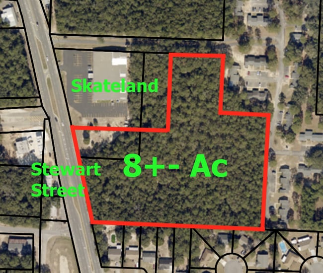
6056 Stewart St, Milton, FL 32570

NEARBY LISTINGS FOR SALE OR LEASE
Property Detail
6056 Stewart St
Pensacola-Ferry Pass-Brent, FL
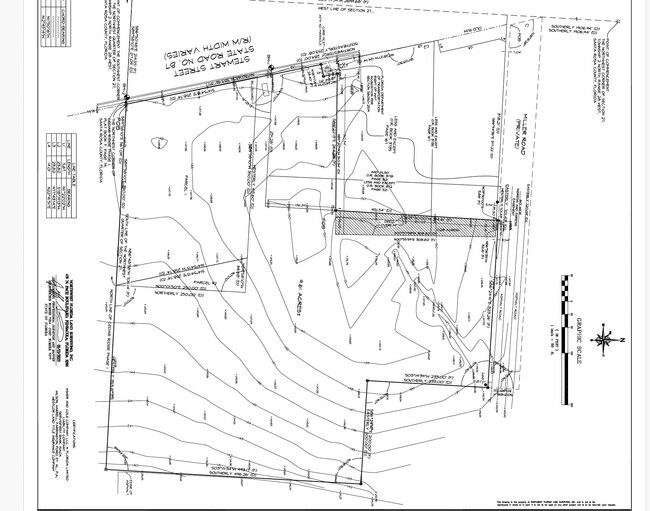
** NEWLY DESCRIBED FOR 2022 ** COM NW COR 27-2N-28W TH S031939W 2699.68 FT TO SW COR OF NW4 TH S865048E 214.55 FT TO I/S ELY R/W ST RD #87 (STEWART ST) FOR POB TH N113048W ALNG SAID R/W 383.96 FT TH N781714E 23.40 FT TH N112401W 27.14 FT TH S892213E
27-2N-28-0000-00164-0000
Santa Rosa
Commercialacreage
Florida
2024
9.46 AC
2025
Avalon Beach/Milton
010505
Pensacola
DEMOGRAPHICS near 6056 Stewart St
1 Mile
3 Mile
5 Mile
2024 Total Population
5,337
24,527
45,346
2029 Population
6,140
28,090
51,930
Pop Growth 2024-2029
+ 15.05%
+ 14.53%
+ 14.52%
Average Age
37
40
40
2024 Total Households
2,048
9,630
17,047
HH Growth 2024-2029
+ 15.38%
+ 14.86%
+ 15.03%
Median Household Inc
$58,823
$67,097
$69,773
Avg Household Size
2.60
2.50
2.50
2024 Avg HH Vehicles
2.00
2.00
2.00
Median Home Value
$141,744
$226,011
$227,844
Median Year Built
1984
1986
1991
Nearby Places
Map Layers
Map Styles
 Street
 Aerial
- Restaurants
- Banks
- Shops
- Fitness
- Groceries
PUBLIC TRANSPORTATION
AIRPORT
Pensacola International
DRIVE
WALK
Distance
Pensacola International
40 min
22.3 mi
SALE & LEASE HISTORY
LISTING DATE
SALE/LEASE

Oct 19, 2023
For Sale
Mar 23, 2021
For Sale
Jan 02, 2025
For Lease
Nearby Properties
Address
Land Use
TOTAL SIZE
Lot Size
Zoning
Address
Land Use
TOTAL SIZE
Lot Size
Zoning
173,250 SF
28.91 AC
C1
Address
Land Use
TOTAL SIZE
Lot Size
Zoning
80,314 SF
9.76 AC
C1
Address
Land Use
TOTAL SIZE
Lot Size
Zoning
8,223 SF
40 AC
Address
Land Use
TOTAL SIZE
Lot Size
Zoning
102,921 SF
5 AC
R3
Address
Land Use
TOTAL SIZE
Lot Size
Zoning
113,178 SF
8.61 AC
HCD
Address
Land Use
TOTAL SIZE
Lot Size
Zoning
151,842 SF
14.28 AC
C2
Address
Land Use
TOTAL SIZE
Lot Size
Zoning
147,443 SF
11.44 AC
I1
Address
Land Use
TOTAL SIZE
Lot Size
Zoning
39,570 SF
0.36 AC
C1
Address
Land Use
TOTAL SIZE
Lot Size
Zoning
68,026 SF
2.07 AC
RC1
Address
Land Use
TOTAL SIZE
Lot Size
Zoning
16,903 SF
11 AC
AG-RR
Address
Land Use
TOTAL SIZE
Lot Size
Zoning
91,887 SF
10.83 AC
C1
Address
Land Use
TOTAL SIZE
Lot Size
Zoning
10 AC
R1A
Address
Land Use
TOTAL SIZE
Lot Size
Zoning
82,994 SF
6 AC
RR1
Address
Land Use
TOTAL SIZE
Lot Size
Zoning
49,540 SF
2.30 AC
HCD
Address
Land Use
TOTAL SIZE
Lot Size
Zoning
40,142 SF
5.28 AC
R3
Address
Land Use
TOTAL SIZE
Lot Size
Zoning
46,613 SF
5.72 AC
C1
Address
Land Use
TOTAL SIZE
Lot Size
Zoning
72,208 SF
66.85 AC
C2
Address
Land Use
TOTAL SIZE
Lot Size
Zoning
60,717 SF
4.43 AC
HCD
Address
Land Use
TOTAL SIZE
Lot Size
Zoning
15 AC
R1A
Address
Land Use
TOTAL SIZE
Lot Size
Zoning
22.09 AC
PE
Address
Land Use
TOTAL SIZE
Lot Size
Zoning
35,405 SF
2.55 AC
R3
Address
Land Use
TOTAL SIZE
Lot Size
Zoning
48,463 SF
10.64 AC
R3
Address
Land Use
TOTAL SIZE
Lot Size
Zoning
24,801 SF
2.32 AC
C2
Address
Land Use
TOTAL SIZE
Lot Size
Zoning
43,399 SF
9.24 AC
R1A
Address
Land Use
TOTAL SIZE
Lot Size
Zoning
37,845 SF
2.24 AC
R3
Address
Land Use
TOTAL SIZE
Lot Size
Zoning
48,242 SF
4.94 AC
HCD
Address
Land Use
TOTAL SIZE
Lot Size
Zoning
48,990 SF
3.68 AC
C1
Address
Land Use
TOTAL SIZE
Lot Size
Zoning
25,264 SF
3.72 AC
C2
Address
Land Use
TOTAL SIZE
Lot Size
Zoning
34,555 SF
6.05 AC
R3
The World's #1 Commercial Real Estate Marketplace
Connect with us
© 2025 CoStar Group
The information above has been obtained from sources believed reliable. While we do not doubt its accuracy we have not verified it and make no guarantee, warranty or representation about it. It is your responsibility to independently confirm its accuracy and completeness. Any projections, opinions, assumptions, or estimates used are for example only and do not represent the current or future performance of the property. The value of this transaction to you depends on tax and other factors which should be evaluated by your tax, financial, and legal advisors. You and your advisors should conduct a careful, independent investigation of the property to determine to your satisfaction the suitability of the property for your needs.