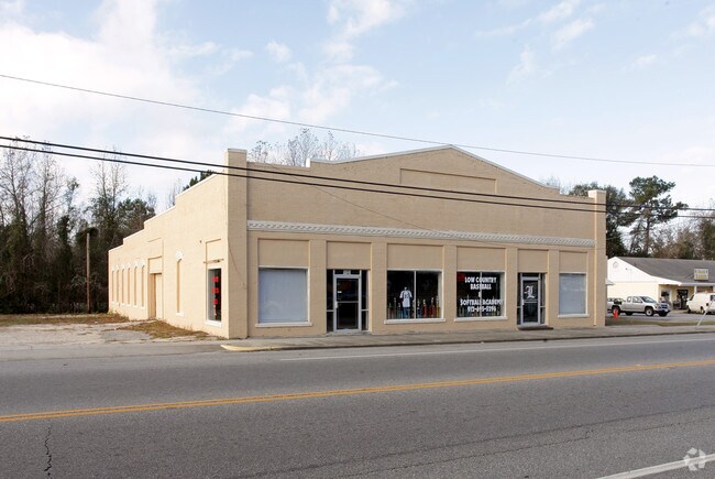
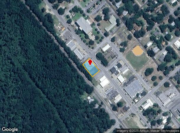
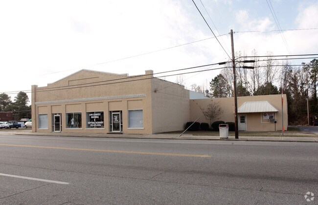
Property Record
606 N Laurel St, Springfield, GA 31329
NEARBY LISTINGS FOR SALE OR LEASE
Property Detail
606 N Laurel St
Savannah, GA
S101: City Of Springfield Comm
S1010-00000-004-A00
LOTS 1 - 6 BLK 18 LANDDIST: 11; COMMERCIAL LARGE TRACTS
Storebuilding
Effingham
X
Georgia
13103C0252E
1-6
2025
0.41 AC
2025
Effingham County
030204
Savannah
6,072 SF
DEMOGRAPHICS near 606 N Laurel St
1 Mile
3 Mile
5 Mile
2024 Total Population
2,728
6,410
13,509
2029 Population
3,155
7,444
15,761
Pop Growth 2024-2029
+ 15.65%
+ 16.13%
+ 16.67%
Average Age
38
38
37
2024 Total Households
928
2,185
4,648
HH Growth 2024-2029
+ 15.73%
+ 16.16%
+ 16.65%
Median Household Inc
$56,929
$63,262
$69,310
Avg Household Size
2.80
2.80
2.80
2024 Avg HH Vehicles
2.00
2.00
2.00
Median Home Value
$210,944
$223,142
$226,390
Median Year Built
1989
1997
2000
Nearby Places
Map Layers
Map Styles
 Street
 Aerial
- Restaurants
- Banks
- Shops
- Fitness
- Groceries
PUBLIC TRANSPORTATION
AIRPORT
Savannah/Hilton Head International
DRIVE
WALK
Distance
Savannah/Hilton Head International
36 min
24.0 mi
Freight Ports
Georgia Ports - Savannah
DRIVE
WALK
Distance
Georgia Ports - Savannah
34 min
22.7 mi
Nearby Properties
Address
Land Use
TOTAL SIZE
Lot Size
Zoning
Address
Land Use
TOTAL SIZE
Lot Size
Zoning
6,914 SF
11.15 AC
B-1
Address
Land Use
TOTAL SIZE
Lot Size
Zoning
52,779 SF
0.82 AC
B-2
Address
Land Use
TOTAL SIZE
Lot Size
Zoning
10,118 SF
16.75 AC
R-3
Address
Land Use
TOTAL SIZE
Lot Size
Zoning
42,403 SF
30 AC
AR-1
Address
Land Use
TOTAL SIZE
Lot Size
Zoning
21,445 SF
1.60 AC
B-2
Address
Land Use
TOTAL SIZE
Lot Size
Zoning
10,200 SF
6.92 AC
B-1
Address
Land Use
TOTAL SIZE
Lot Size
Zoning
14,472 SF
2.27 AC
B-1
Address
Land Use
TOTAL SIZE
Lot Size
Zoning
27,762 SF
1.45 AC
R-1
Address
Land Use
TOTAL SIZE
Lot Size
Zoning
30,000 SF
18.19 AC
I-1
Address
Land Use
TOTAL SIZE
Lot Size
Zoning
5,066 SF
2.67 AC
B-1
Address
Land Use
TOTAL SIZE
Lot Size
Zoning
137.58 AC
R-6
Address
Land Use
TOTAL SIZE
Lot Size
Zoning
10,857 SF
1.45 AC
B-1
Address
Land Use
TOTAL SIZE
Lot Size
Zoning
13,902 SF
3.85 AC
I-1
Address
Land Use
TOTAL SIZE
Lot Size
Zoning
20,776 SF
0.92 AC
R-1
Address
Land Use
TOTAL SIZE
Lot Size
Zoning
11,036 SF
6.15 AC
R-1
Address
Land Use
TOTAL SIZE
Lot Size
Zoning
17,855 SF
1.16 AC
B-2
Address
Land Use
TOTAL SIZE
Lot Size
Zoning
14.57 AC
B-1
Address
Land Use
TOTAL SIZE
Lot Size
Zoning
4,902 SF
1.99 AC
B-1
Address
Land Use
TOTAL SIZE
Lot Size
Zoning
13,036 SF
3.33 AC
B-1
Address
Land Use
TOTAL SIZE
Lot Size
Zoning
5,949 SF
3.26 AC
AR-1
Address
Land Use
TOTAL SIZE
Lot Size
Zoning
10,000 SF
0.57 AC
B-2
Address
Land Use
TOTAL SIZE
Lot Size
Zoning
10,155 SF
1.39 AC
B-1
Address
Land Use
TOTAL SIZE
Lot Size
Zoning
22,516 SF
0.61 AC
B-2
Address
Land Use
TOTAL SIZE
Lot Size
Zoning
6,916 SF
0.92 AC
B-2
Address
Land Use
TOTAL SIZE
Lot Size
Zoning
2,108 SF
2.29 AC
B-1
Address
Land Use
TOTAL SIZE
Lot Size
Zoning
5,040 SF
9.06 AC
AR-1
Address
Land Use
TOTAL SIZE
Lot Size
Zoning
7,800 SF
2.84 AC
B-2
Address
Land Use
TOTAL SIZE
Lot Size
Zoning
5,060 SF
1.52 AC
B-1
Address
Land Use
TOTAL SIZE
Lot Size
Zoning
1,886 SF
6 AC
B-2
Address
Land Use
TOTAL SIZE
Lot Size
Zoning
112.98 AC
R-1
The World's #1 Commercial Real Estate Marketplace
Connect with us
© 2025 CoStar Group
The information above has been obtained from sources believed reliable. While we do not doubt its accuracy we have not verified it and make no guarantee, warranty or representation about it. It is your responsibility to independently confirm its accuracy and completeness. Any projections, opinions, assumptions, or estimates used are for example only and do not represent the current or future performance of the property. The value of this transaction to you depends on tax and other factors which should be evaluated by your tax, financial, and legal advisors. You and your advisors should conduct a careful, independent investigation of the property to determine to your satisfaction the suitability of the property for your needs.