Property Record
606 S Charles Way, Strafford, MO 65757
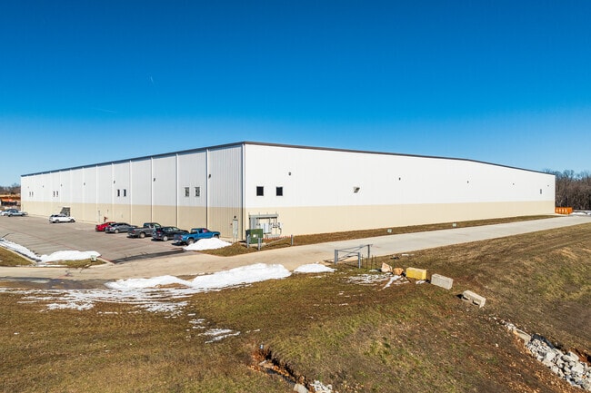

Property Detail
606 S Charles Way
Springfield, MO
SOUTHWEST MO RAIL & BUSINESS PARK PHASE 1 LOT 4
11-04-208-044
GREENE
Warehouse
Missouri
INC
4
B and X Area of moderate flood hazard, usually the area between the limits of the 100-year and 500-year floods.
10.11 AC
2025
Outlying Greene County
2025
Springfield
004601
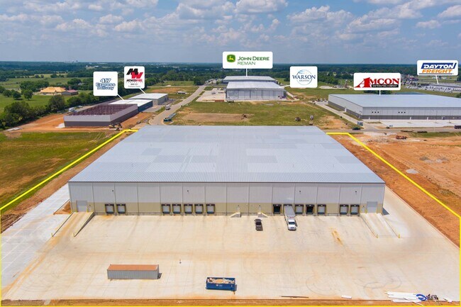
NEARBY LISTINGS FOR SALE OR LEASE
DEMOGRAPHICS near 606 S Charles Way
1 mile
3 mile
5 mile
2025 Total Population
1,802
4,580
10,227
2030 Population
1,879
4,763
10,633
Pop Growth 2025-2030
+ 4.27%
+ 4.00%
+ 3.97%
Average Age
39
40
42
2025 Total Households
676
1,742
3,991
HH Growth 2025-2030
+ 4.44%
+ 4.19%
+ 4.11%
Median Household Inc
$70,227
$75,119
$87,187
Avg Household Size
2.60
2.50
2.50
2025 Avg HH Vehicles
2.00
2.00
2.00
Median Home Value
$191,158
$222,031
$311,130
Median Year Built
1990
1990
1992
Nearby Places
Map Layers
Map Styles
 Street
 Aerial
Layers
 Traffic
 Biking
Places
Listings with unknown addresses are not visible on the map
- Restaurants
- Banks
- Shops
- Fitness
- Groceries
SALE & LEASE HISTORY
LISTING DATE
SALE/LEASE

Jul 19, 2022
For Lease
Jul 19, 2022
For Sale
Nearby Properties
Address
Land Use
TOTAL SIZE
Lot Size
Zoning
Address
Land Use
TOTAL SIZE
Lot Size
Zoning
9.17 AC
INC.
Address
Land Use
TOTAL SIZE
Lot Size
Zoning
8.66 AC
INC
Address
Land Use
TOTAL SIZE
Lot Size
Zoning
85.20 AC
Address
Land Use
TOTAL SIZE
Lot Size
Zoning
10.07 AC
INC.
Address
Land Use
TOTAL SIZE
Lot Size
Zoning
92,899 SF
33.70 AC
M-1
Address
Land Use
TOTAL SIZE
Lot Size
Zoning
17.48 AC
INC
Address
Land Use
TOTAL SIZE
Lot Size
Zoning
Address
Land Use
TOTAL SIZE
Lot Size
Zoning
17.36 AC
INC.
Address
Land Use
TOTAL SIZE
Lot Size
Zoning
10 AC
INC.
Address
Land Use
TOTAL SIZE
Lot Size
Zoning
12.03 AC
INC
Address
Land Use
TOTAL SIZE
Lot Size
Zoning
14.70 AC
M-1
Address
Land Use
TOTAL SIZE
Lot Size
Zoning
61,640 SF
34.65 AC
INC
Address
Land Use
TOTAL SIZE
Lot Size
Zoning
Address
Land Use
TOTAL SIZE
Lot Size
Zoning
40,920 SF
4.20 AC
M-1
Address
Land Use
TOTAL SIZE
Lot Size
Zoning
2.97 AC
INC
Address
Land Use
TOTAL SIZE
Lot Size
Zoning
23,806 SF
42.74 AC
INC
Address
Land Use
TOTAL SIZE
Lot Size
Zoning
2.79 AC
INC
Address
Land Use
TOTAL SIZE
Lot Size
Zoning
6.93 AC
INC
Address
Land Use
TOTAL SIZE
Lot Size
Zoning
31,101 SF
12 AC
INC
Address
Land Use
TOTAL SIZE
Lot Size
Zoning
1,364 SF
14.79 AC
INC
Address
Land Use
TOTAL SIZE
Lot Size
Zoning
8.98 AC
INC
Address
Land Use
TOTAL SIZE
Lot Size
Zoning
Address
Land Use
TOTAL SIZE
Lot Size
Zoning
22,450 SF
31.65 AC
INC
Address
Land Use
TOTAL SIZE
Lot Size
Zoning
4.90 AC
INC
Address
Land Use
TOTAL SIZE
Lot Size
Zoning
2.06 AC
INC.
Address
Land Use
TOTAL SIZE
Lot Size
Zoning
23,636 SF
10.20 AC
INC
Address
Land Use
TOTAL SIZE
Lot Size
Zoning
8,146 SF
2.32 AC
INC
Address
Land Use
TOTAL SIZE
Lot Size
Zoning
4,253 SF
26.40 AC
INC
Address
Land Use
TOTAL SIZE
Lot Size
Zoning
16.22 AC
The World's #1 Commercial Real Estate Marketplace
Connect with us
© 2026 CoStar Group
The information above has been obtained from sources believed reliable. While we do not doubt its accuracy we have not verified it and make no guarantee, warranty or representation about it. It is your responsibility to independently confirm its accuracy and completeness. Any projections, opinions, assumptions, or estimates used are for example only and do not represent the current or future performance of the property. The value of this transaction to you depends on tax and other factors which should be evaluated by your tax, financial, and legal advisors. You and your advisors should conduct a careful, independent investigation of the property to determine to your satisfaction the suitability of the property for your needs.