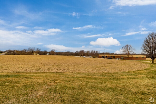
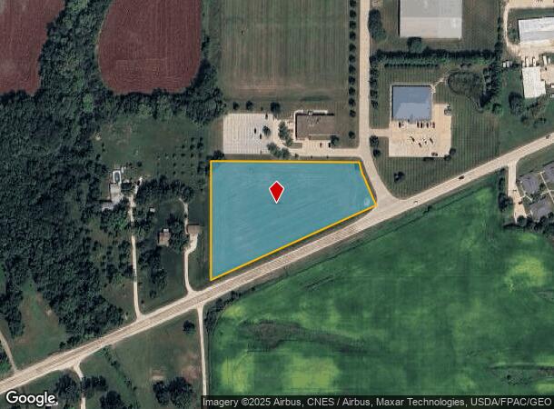
Property Record
606 Visions Pkwy, Adel, IA 50003
NEARBY LISTINGS FOR SALE OR LEASE
Property Detail
606 Visions Pkwy
Des Moines-West Des Moines, IA
Adel Industrial Park Amended Plat 2
11-31-127-016
ADEL INDUSTRIAL PARK AMENDED PLAT NO 2 LOT 1
Commercialnec
Dallas
X
Iowa
19049C0306G
1
2023
3.10 AC
2024
Outlying Dallas County
050700
Des Moines
DEMOGRAPHICS near 606 Visions Pkwy
1 Mile
3 Mile
5 Mile
2024 Total Population
2,583
7,824
9,375
2029 Population
3,132
9,479
11,340
Pop Growth 2024-2029
+ 21.25%
+ 21.15%
+ 20.96%
Average Age
37
37
38
2024 Total Households
964
2,928
3,501
HH Growth 2024-2029
+ 22.10%
+ 21.96%
+ 21.79%
Median Household Inc
$66,083
$66,565
$69,850
Avg Household Size
2.70
2.70
2.70
2024 Avg HH Vehicles
2.00
2.00
2.00
Median Home Value
$255,038
$253,483
$255,579
Median Year Built
1991
1989
1989
Nearby Places
Map Layers
Map Styles
 Street
 Aerial
- Restaurants
- Banks
- Shops
- Fitness
- Groceries
PUBLIC TRANSPORTATION
AIRPORT
Des Moines International
DRIVE
WALK
Distance
Des Moines International
41 min
25.3 mi
Freight Ports
Port Milwaukee
DRIVE
WALK
Distance
Port Milwaukee
442 min
394.3 mi
Nearby Properties
Address
Land Use
TOTAL SIZE
Lot Size
Zoning
Address
Land Use
TOTAL SIZE
Lot Size
Zoning
Address
Land Use
TOTAL SIZE
Lot Size
Zoning
19.02 AC
Address
Land Use
TOTAL SIZE
Lot Size
Zoning
28,572 SF
1.70 AC
Address
Land Use
TOTAL SIZE
Lot Size
Zoning
16 AC
Address
Land Use
TOTAL SIZE
Lot Size
Zoning
4,950 SF
2.66 AC
Address
Land Use
TOTAL SIZE
Lot Size
Zoning
99,602 SF
5.40 AC
Address
Land Use
TOTAL SIZE
Lot Size
Zoning
5,952 SF
8.62 AC
Address
Land Use
TOTAL SIZE
Lot Size
Zoning
3,029 SF
5.57 AC
Address
Land Use
TOTAL SIZE
Lot Size
Zoning
2,820 SF
11.25 AC
Address
Land Use
TOTAL SIZE
Lot Size
Zoning
11,880 SF
5 AC
Address
Land Use
TOTAL SIZE
Lot Size
Zoning
14,748 SF
6.75 AC
Address
Land Use
TOTAL SIZE
Lot Size
Zoning
4,775 SF
2.11 AC
Address
Land Use
TOTAL SIZE
Lot Size
Zoning
2,432 SF
20.33 AC
Address
Land Use
TOTAL SIZE
Lot Size
Zoning
8,435 SF
0.42 AC
Address
Land Use
TOTAL SIZE
Lot Size
Zoning
16,679 SF
5.44 AC
Address
Land Use
TOTAL SIZE
Lot Size
Zoning
19,078 SF
2.57 AC
Address
Land Use
TOTAL SIZE
Lot Size
Zoning
1.46 AC
Address
Land Use
TOTAL SIZE
Lot Size
Zoning
2,860 SF
7.50 AC
Address
Land Use
TOTAL SIZE
Lot Size
Zoning
5,643 SF
2.25 AC
Address
Land Use
TOTAL SIZE
Lot Size
Zoning
13,777 SF
13.48 AC
Address
Land Use
TOTAL SIZE
Lot Size
Zoning
22,297 SF
8.51 AC
Address
Land Use
TOTAL SIZE
Lot Size
Zoning
6,306 SF
2.50 AC
Address
Land Use
TOTAL SIZE
Lot Size
Zoning
12,000 SF
3.50 AC
Address
Land Use
TOTAL SIZE
Lot Size
Zoning
6,700 SF
0.68 AC
Address
Land Use
TOTAL SIZE
Lot Size
Zoning
4,930 SF
0.80 AC
Address
Land Use
TOTAL SIZE
Lot Size
Zoning
4,026 SF
1 AC
Address
Land Use
TOTAL SIZE
Lot Size
Zoning
8,534 SF
1.87 AC
Address
Land Use
TOTAL SIZE
Lot Size
Zoning
24,000 SF
3.10 AC
Address
Land Use
TOTAL SIZE
Lot Size
Zoning
7,768 SF
1.99 AC
Address
Land Use
TOTAL SIZE
Lot Size
Zoning
16,680 SF
0.80 AC
The World's #1 Commercial Real Estate Marketplace
Connect with us
© 2025 CoStar Group
The information above has been obtained from sources believed reliable. While we do not doubt its accuracy we have not verified it and make no guarantee, warranty or representation about it. It is your responsibility to independently confirm its accuracy and completeness. Any projections, opinions, assumptions, or estimates used are for example only and do not represent the current or future performance of the property. The value of this transaction to you depends on tax and other factors which should be evaluated by your tax, financial, and legal advisors. You and your advisors should conduct a careful, independent investigation of the property to determine to your satisfaction the suitability of the property for your needs.