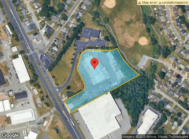
Property Record
606 W Basin Rd, New Castle, DE 19720


Current Lease Availabilities
NEARBY LISTINGS FOR SALE OR LEASE
Property Detail
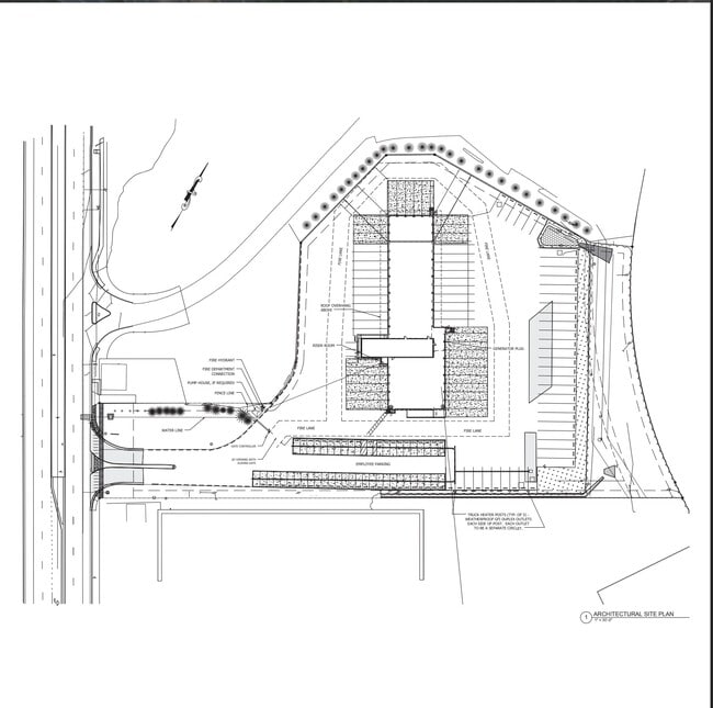
606 W Basin Rd
Philadelphia-Camden-Wilmington, PA-NJ-DE-MD
Old Dominion Freight Line
10-019.10-001
BEG AT IRON PIPE ON NELY SIDE OF BASIN RD AKA DELAWARE ROUTE 141 AT NWLY COR FOR
Truckterminal
New Castle
X
Delaware
10003C0162K
a
2024
4.86 AC
2024
New Castle County
015200
Philadelphia
3,120 SF
DEMOGRAPHICS near 606 W Basin Rd
1 Mile
3 Mile
5 Mile
2024 Total Population
8,080
58,737
182,459
2029 Population
8,110
59,505
185,536
Pop Growth 2024-2029
+ 0.37%
+ 1.31%
+ 1.69%
Average Age
39
40
39
2024 Total Households
2,971
22,730
73,325
HH Growth 2024-2029
+ 0.30%
+ 1.31%
+ 1.76%
Median Household Inc
$65,677
$60,877
$59,217
Avg Household Size
2.60
2.50
2.40
2024 Avg HH Vehicles
2.00
2.00
2.00
Median Home Value
$185,386
$202,586
$217,417
Median Year Built
1960
1962
1962
Nearby Places
- Restaurants
- Banks
- Shops
- Fitness
- Groceries
PUBLIC TRANSPORTATION
COMMUTER RAIL
Churchmans Crossing (R2 - Southeastern Pennsylvania Transportation Authority Regional Rail (SEPTA Regional Rail))
DRIVE
WALK
Distance
Churchmans Crossing (R2 - Southeastern Pennsylvania Transportation Authority Regional Rail (SEPTA Regional Rail))
10 min
5.7 mi
Wilmington (R2 - Southeastern Pennsylvania Transportation Authority Regional Rail (SEPTA Regional Rail))
DRIVE
WALK
Distance
Wilmington (R2 - Southeastern Pennsylvania Transportation Authority Regional Rail (SEPTA Regional Rail))
11 min
6.1 mi
AIRPORT
Philadelphia International
DRIVE
WALK
Distance
Philadelphia International
38 min
26.7 mi
Freight Ports
Port of Wilmington, RI
DRIVE
WALK
Distance
Port of Wilmington, RI
12 min
6.6 mi
Nearby Properties
Address
Land Use
TOTAL SIZE
Lot Size
Zoning
Address
Land Use
TOTAL SIZE
Lot Size
Zoning
163,588 SF
1,229.95 AC
I
Address
Land Use
TOTAL SIZE
Lot Size
Zoning
624,255 SF
132.95 AC
SR
Address
Land Use
TOTAL SIZE
Lot Size
Zoning
803,690 SF
155.50 AC
NCPUD
Address
Land Use
TOTAL SIZE
Lot Size
Zoning
324,073 SF
77.78 AC
S
Address
Land Use
TOTAL SIZE
Lot Size
Zoning
197,726 SF
25 AC
I
Address
Land Use
TOTAL SIZE
Lot Size
Zoning
116,042 SF
108.83 AC
SR
Address
Land Use
TOTAL SIZE
Lot Size
Zoning
25,801 SF
23.84 AC
S
Address
Land Use
TOTAL SIZE
Lot Size
Zoning
352,104 SF
16.35 AC
BP
Address
Land Use
TOTAL SIZE
Lot Size
Zoning
485,987 SF
79.27 AC
21IOP
Address
Land Use
TOTAL SIZE
Lot Size
Zoning
248,554 SF
18.58 AC
CR
Address
Land Use
TOTAL SIZE
Lot Size
Zoning
51,286 SF
15.60 AC
CR
Address
Land Use
TOTAL SIZE
Lot Size
Zoning
203,570 SF
83.85 AC
OR
Address
Land Use
TOTAL SIZE
Lot Size
Zoning
56,352 SF
11.29 AC
I
Address
Land Use
TOTAL SIZE
Lot Size
Zoning
61,928 SF
128.88 AC
HI
Address
Land Use
TOTAL SIZE
Lot Size
Zoning
281,611 SF
26.39 AC
NCAP
Address
Land Use
TOTAL SIZE
Lot Size
Zoning
268,661 SF
28.38 AC
NCAP
Address
Land Use
TOTAL SIZE
Lot Size
Zoning
295,200 SF
17.94 AC
NCAP
Address
Land Use
TOTAL SIZE
Lot Size
Zoning
421,754 SF
47.58 AC
21I
Address
Land Use
TOTAL SIZE
Lot Size
Zoning
64,585 SF
14.61 AC
NC6.5
Address
Land Use
TOTAL SIZE
Lot Size
Zoning
213,565 SF
11.73 AC
21I
Address
Land Use
TOTAL SIZE
Lot Size
Zoning
166,492 SF
19.73 AC
S
Address
Land Use
TOTAL SIZE
Lot Size
Zoning
3,850 SF
12.43 AC
CR
Address
Land Use
TOTAL SIZE
Lot Size
Zoning
16,920 SF
12.50 AC
I
Address
Land Use
TOTAL SIZE
Lot Size
Zoning
358,315 SF
6.39 AC
BP
Address
Land Use
TOTAL SIZE
Lot Size
Zoning
115,880 SF
20.85 AC
21IOP
Address
Land Use
TOTAL SIZE
Lot Size
Zoning
79,778 SF
8.83 AC
NC6.5
Address
Land Use
TOTAL SIZE
Lot Size
Zoning
115,455 SF
20.58 AC
CR
Address
Land Use
TOTAL SIZE
Lot Size
Zoning
388,314 SF
22.06 AC
NCAP
Address
Land Use
TOTAL SIZE
Lot Size
Zoning
30,127 SF
6.53 AC
CR
Address
Land Use
TOTAL SIZE
Lot Size
Zoning
96,676 SF
6.17 AC
BP
The World's #1 Commercial Real Estate Marketplace
Connect with us
© 2025 CoStar Group
The information above has been obtained from sources believed reliable. While we do not doubt its accuracy we have not verified it and make no guarantee, warranty or representation about it. It is your responsibility to independently confirm its accuracy and completeness. Any projections, opinions, assumptions, or estimates used are for example only and do not represent the current or future performance of the property. The value of this transaction to you depends on tax and other factors which should be evaluated by your tax, financial, and legal advisors. You and your advisors should conduct a careful, independent investigation of the property to determine to your satisfaction the suitability of the property for your needs.