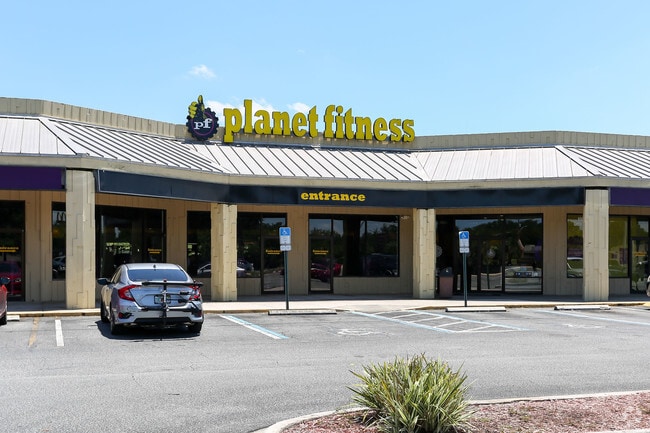
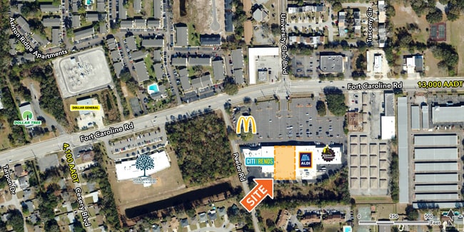
Property Record
6060 Fort Caroline Rd, Jacksonville, FL 32277
Current Lease Availabilities
NEARBY LISTINGS FOR SALE OR LEASE
Property Detail
6060 Fort Caroline Rd
Jacksonville, FL
Floral Bluff Est 1St Addn
113238-0400
17-95 04-2S-27E 8.1 FIRST ADDITION TO FLORAL BLUFF ESTATES PT LOTS 36,37 RECD O/R 21077-666(EX PT IN R/W) BEING PARCELS C,D
Regionalshoppingcenterormallwithanchorstore
Duval
X
Florida
12031C0376J
36,37
2025
8.10 AC
2026
Arlington
014901
Jacksonville (Florida)
90,928 SF
DEMOGRAPHICS near 6060 Fort Caroline Rd
1 Mile
3 Mile
5 Mile
2024 Total Population
16,199
63,937
161,875
2029 Population
16,858
66,807
170,462
Pop Growth 2024-2029
+ 4.07%
+ 4.49%
+ 5.30%
Average Age
36
38
38
2024 Total Households
5,846
24,530
65,322
HH Growth 2024-2029
+ 4.07%
+ 4.60%
+ 5.52%
Median Household Inc
$44,626
$49,390
$43,689
Avg Household Size
2.40
2.50
2.30
2024 Avg HH Vehicles
2.00
2.00
1.00
Median Home Value
$189,114
$191,559
$193,256
Median Year Built
1973
1971
1972
Nearby Places
Map Layers
Map Styles
 Street
 Aerial
- Restaurants
- Banks
- Shops
- Fitness
- Groceries
PUBLIC TRANSPORTATION
AIRPORT
Jacksonville International
DRIVE
WALK
Distance
Jacksonville International
32 min
19.1 mi
Freight Ports
Jacksonville Port
DRIVE
WALK
Distance
Jacksonville Port
17 min
8.0 mi
Nearby Properties
Address
Land Use
TOTAL SIZE
Lot Size
Zoning
Address
Land Use
TOTAL SIZE
Lot Size
Zoning
1,146,106 SF
206.66 AC
PBF-2
Address
Land Use
TOTAL SIZE
Lot Size
Zoning
557,032 SF
40.06 AC
PUD
Address
Land Use
TOTAL SIZE
Lot Size
Zoning
488,100 SF
35.32 AC
CRO
Address
Land Use
TOTAL SIZE
Lot Size
Zoning
410,225 SF
22.11 AC
PUD
Address
Land Use
TOTAL SIZE
Lot Size
Zoning
324,687 SF
26.60 AC
RMD-D
Address
Land Use
TOTAL SIZE
Lot Size
Zoning
394,122 SF
17.19 AC
RMD-D
Address
Land Use
TOTAL SIZE
Lot Size
Zoning
300,360 SF
14.44 AC
RMD-C
Address
Land Use
TOTAL SIZE
Lot Size
Zoning
328,457 SF
23.99 AC
RMD-D
Address
Land Use
TOTAL SIZE
Lot Size
Zoning
184,221 SF
12.05 AC
PUD
Address
Land Use
TOTAL SIZE
Lot Size
Zoning
305,254 SF
26.77 AC
PUD
Address
Land Use
TOTAL SIZE
Lot Size
Zoning
222,235 SF
14.58 AC
RMD-D
Address
Land Use
TOTAL SIZE
Lot Size
Zoning
604,760 SF
11.06 AC
IW
Address
Land Use
TOTAL SIZE
Lot Size
Zoning
231,453 SF
24.55 AC
PUD
Address
Land Use
TOTAL SIZE
Lot Size
Zoning
276,782 SF
50.66 AC
IW
Address
Land Use
TOTAL SIZE
Lot Size
Zoning
229,298 SF
11.74 AC
RMD-D
Address
Land Use
TOTAL SIZE
Lot Size
Zoning
101,206 SF
9.32 AC
PUD
Address
Land Use
TOTAL SIZE
Lot Size
Zoning
252,229 SF
10.74 AC
RMD-D
Address
Land Use
TOTAL SIZE
Lot Size
Zoning
180,180 SF
11.06 AC
CRO
Address
Land Use
TOTAL SIZE
Lot Size
Zoning
211,429 SF
18.27 AC
PUD
Address
Land Use
TOTAL SIZE
Lot Size
Zoning
74,137 SF
59.05 AC
IW
Address
Land Use
TOTAL SIZE
Lot Size
Zoning
259,690 SF
17.83 AC
PUD
Address
Land Use
TOTAL SIZE
Lot Size
Zoning
34,251 SF
5.02 AC
PUD
Address
Land Use
TOTAL SIZE
Lot Size
Zoning
107,850 SF
14.39 AC
PBF-2
Address
Land Use
TOTAL SIZE
Lot Size
Zoning
1,312 SF
56.81 AC
RMD-A
Address
Land Use
TOTAL SIZE
Lot Size
Zoning
195,639 SF
11.07 AC
RMD-D
Address
Land Use
TOTAL SIZE
Lot Size
Zoning
71,741 SF
6.60 AC
PUD
Address
Land Use
TOTAL SIZE
Lot Size
Zoning
285,579 SF
14.89 AC
CRO
Address
Land Use
TOTAL SIZE
Lot Size
Zoning
122,440 SF
9.27 AC
PUD
Address
Land Use
TOTAL SIZE
Lot Size
Zoning
260,511 SF
48.83 AC
IW
Address
Land Use
TOTAL SIZE
Lot Size
Zoning
75,765 SF
3.29 AC
CCG-1
The World's #1 Commercial Real Estate Marketplace
Connect with us
© 2025 CoStar Group
The information above has been obtained from sources believed reliable. While we do not doubt its accuracy we have not verified it and make no guarantee, warranty or representation about it. It is your responsibility to independently confirm its accuracy and completeness. Any projections, opinions, assumptions, or estimates used are for example only and do not represent the current or future performance of the property. The value of this transaction to you depends on tax and other factors which should be evaluated by your tax, financial, and legal advisors. You and your advisors should conduct a careful, independent investigation of the property to determine to your satisfaction the suitability of the property for your needs.