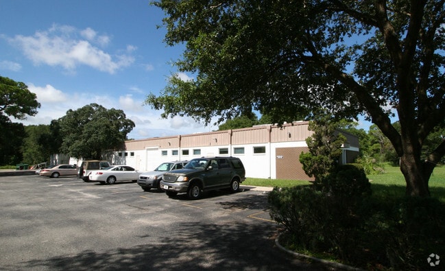
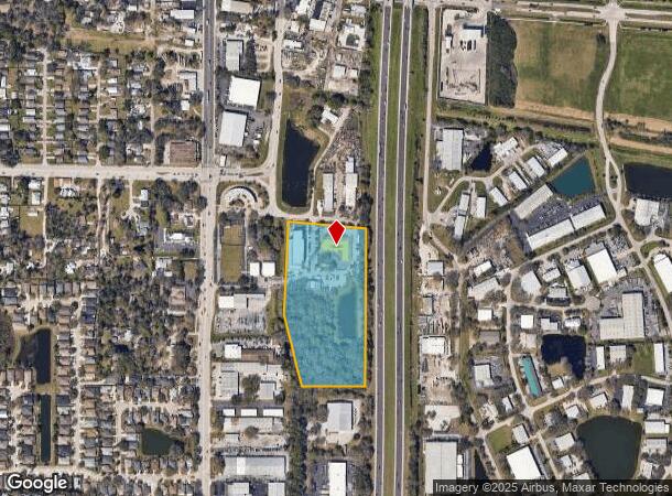
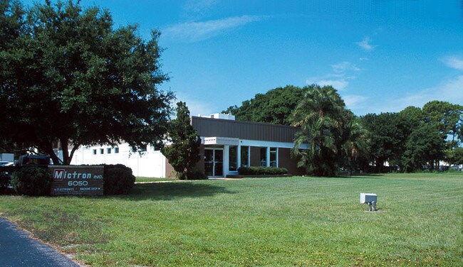
Property Record
6062 Porter Way, Sarasota, FL 34232
NEARBY LISTINGS FOR SALE OR LEASE
Property Detail
6062 Porter Way
North Port-Bradenton-Sarasota, FL
Palmer Farms 2Nd Unit
0049-01-0004
PART OF LOTS 67 & 69 DESC AS BEG AT NE COR LOT 67 FOR A POB TH S-0-01-23-E ALG E LINE & EXT THEREOF 997.39 FT TO S LINE OF LOT 69 TH S-89-45-W ALG S LINE 400.25 FT TO E R/W BDRY OF 52 FT CANAL TH
Countyproperty
Sarasota
AE
Florida
12115C0154G
67,69
0
11.22 AC
2025
Sarasota
001303
Tampa/St Petersburg
24,660 SF
DEMOGRAPHICS near 6062 Porter Way
1 Mile
3 Mile
5 Mile
2024 Total Population
5,713
57,022
146,049
2029 Population
6,506
64,956
167,258
Pop Growth 2024-2029
+ 13.88%
+ 13.91%
+ 14.52%
Average Age
41
45
46
2024 Total Households
2,210
23,887
63,568
HH Growth 2024-2029
+ 13.80%
+ 13.86%
+ 14.50%
Median Household Inc
$76,166
$76,751
$71,041
Avg Household Size
2.40
2.30
2.20
2024 Avg HH Vehicles
2.00
2.00
2.00
Median Home Value
$341,532
$317,943
$323,605
Median Year Built
1989
1985
1983
Nearby Places
Map Layers
Map Styles
 Street
 Aerial
- Restaurants
- Banks
- Shops
- Fitness
- Groceries
PUBLIC TRANSPORTATION
AIRPORT
Sarasota/Bradenton International
DRIVE
WALK
Distance
Sarasota/Bradenton International
22 min
11.4 mi
Freight Ports
Port Manatee
DRIVE
WALK
Distance
Port Manatee
37 min
26.2 mi
Nearby Properties
Address
Land Use
TOTAL SIZE
Lot Size
Zoning
Address
Land Use
TOTAL SIZE
Lot Size
Zoning
92,398 SF
178.58 AC
OUE1
Address
Land Use
TOTAL SIZE
Lot Size
Zoning
409,467 SF
36.72 AC
RMF2
Address
Land Use
TOTAL SIZE
Lot Size
Zoning
359,089 SF
16.72 AC
PCD
Address
Land Use
TOTAL SIZE
Lot Size
Zoning
370,367 SF
27.32 AC
OPI
Address
Land Use
TOTAL SIZE
Lot Size
Zoning
366,256 SF
32.53 AC
RMF3
Address
Land Use
TOTAL SIZE
Lot Size
Zoning
332,686 SF
37.78 AC
VPD
Address
Land Use
TOTAL SIZE
Lot Size
Zoning
318,350 SF
14.30 AC
ILW
Address
Land Use
TOTAL SIZE
Lot Size
Zoning
415,689 SF
37.52 AC
OPI
Address
Land Use
TOTAL SIZE
Lot Size
Zoning
350,210 SF
13.36 AC
PED
Address
Land Use
TOTAL SIZE
Lot Size
Zoning
334,284 SF
30.55 AC
RMF3
Address
Land Use
TOTAL SIZE
Lot Size
Zoning
349,363 SF
22.58 AC
VPD
Address
Land Use
TOTAL SIZE
Lot Size
Zoning
352,070 SF
8.87 AC
ILW
Address
Land Use
TOTAL SIZE
Lot Size
Zoning
263,961 SF
18.88 AC
RMF3
Address
Land Use
TOTAL SIZE
Lot Size
Zoning
313,441 SF
26.91 AC
RSF2
Address
Land Use
TOTAL SIZE
Lot Size
Zoning
216,684 SF
30.52 AC
RMF2
Address
Land Use
TOTAL SIZE
Lot Size
Zoning
94,981 SF
6 AC
PCD
Address
Land Use
TOTAL SIZE
Lot Size
Zoning
374,477 SF
15.55 AC
PED
Address
Land Use
TOTAL SIZE
Lot Size
Zoning
206,788 SF
122.30 AC
GU
Address
Land Use
TOTAL SIZE
Lot Size
Zoning
195,342 SF
20.20 AC
CSC
Address
Land Use
TOTAL SIZE
Lot Size
Zoning
170,631 SF
23.70 AC
RMF2
Address
Land Use
TOTAL SIZE
Lot Size
Zoning
157,351 SF
10.98 AC
ILW
Address
Land Use
TOTAL SIZE
Lot Size
Zoning
109,470 SF
17.23 AC
RSF2
Address
Land Use
TOTAL SIZE
Lot Size
Zoning
118,713 SF
31.70 AC
MCI
Address
Land Use
TOTAL SIZE
Lot Size
Zoning
196,331 SF
55.82 AC
GU
Address
Land Use
TOTAL SIZE
Lot Size
Zoning
139,916 SF
10.05 AC
PCD
Address
Land Use
TOTAL SIZE
Lot Size
Zoning
86,651 SF
22.68 AC
PED
Address
Land Use
TOTAL SIZE
Lot Size
Zoning
205,136 SF
17.32 AC
RMF2
Address
Land Use
TOTAL SIZE
Lot Size
Zoning
6,232 SF
37.84 AC
RMH
Address
Land Use
TOTAL SIZE
Lot Size
Zoning
64,454 SF
2.56 AC
PED
Address
Land Use
TOTAL SIZE
Lot Size
Zoning
89,318 SF
13.62 AC
CSC
The World's #1 Commercial Real Estate Marketplace
Connect with us
© 2026 CoStar Group
The information above has been obtained from sources believed reliable. While we do not doubt its accuracy we have not verified it and make no guarantee, warranty or representation about it. It is your responsibility to independently confirm its accuracy and completeness. Any projections, opinions, assumptions, or estimates used are for example only and do not represent the current or future performance of the property. The value of this transaction to you depends on tax and other factors which should be evaluated by your tax, financial, and legal advisors. You and your advisors should conduct a careful, independent investigation of the property to determine to your satisfaction the suitability of the property for your needs.