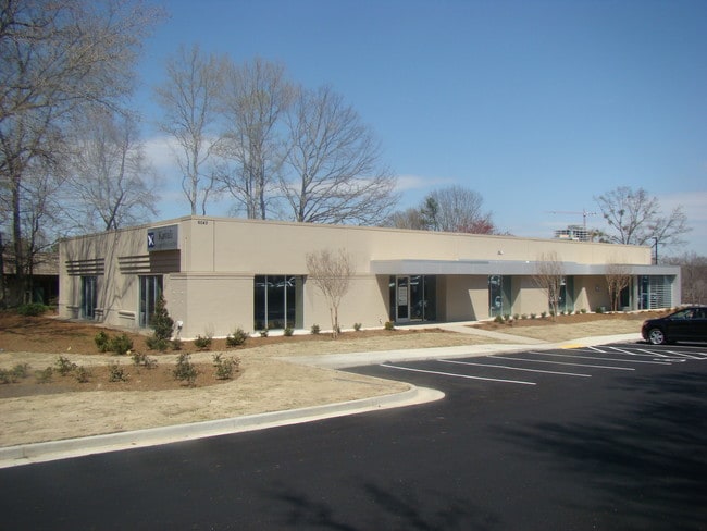
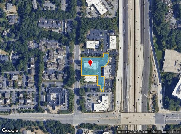
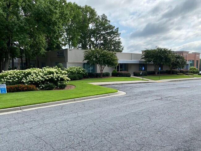
Property Record
6065 Barfield Rd, Atlanta, GA 30328
NEARBY LISTINGS FOR SALE OR LEASE
Property Detail
6065 Barfield Rd
Officebuilding
Fulton
X
Georgia
13089C0011K
1.53 AC
2024
Central Perimeter
2025
Atlanta
010133
Atlanta-Sandy Springs-Roswell, GA
21,592 SF
17-0036-LL-078-9
DEMOGRAPHICS near 6065 Barfield Rd
1 Mile
3 Mile
5 Mile
2024 Total Population
9,848
104,608
236,635
2029 Population
10,215
106,024
239,097
Pop Growth 2024-2029
+ 3.73%
+ 1.35%
+ 1.04%
Average Age
40
39
39
2024 Total Households
5,550
46,894
104,800
HH Growth 2024-2029
+ 3.51%
+ 1.54%
+ 1.23%
Median Household Inc
$95,292
$108,835
$107,635
Avg Household Size
1.70
2.20
2.20
2024 Avg HH Vehicles
1.00
2.00
2.00
Median Home Value
$445,348
$619,846
$626,049
Median Year Built
2003
1989
1988
Nearby Places
- Restaurants
- Banks
- Shops
- Fitness
- Groceries
PUBLIC TRANSPORTATION
COMMUTER RAIL
DRIVE
WALK
Distance
16 min
9.5 mi
AIRPORT
Hartsfield - Jackson Atlanta International
DRIVE
WALK
Distance
Hartsfield - Jackson Atlanta International
35 min
22.9 mi
SALE & LEASE HISTORY
LISTING DATE
SALE/LEASE

Oct 11, 2019
For Lease
Nearby Properties
Address
Land Use
TOTAL SIZE
Lot Size
Zoning
Address
Land Use
TOTAL SIZE
Lot Size
Zoning
1,123,714 SF
47.33 AC
C1
Address
Land Use
TOTAL SIZE
Lot Size
Zoning
854,744 SF
2.04 AC
OI
Address
Land Use
TOTAL SIZE
Lot Size
Zoning
374,311 SF
0.19 AC
X
Address
Land Use
TOTAL SIZE
Lot Size
Zoning
216,464 SF
X
Address
Land Use
TOTAL SIZE
Lot Size
Zoning
104,625 SF
0.99 AC
X
Address
Land Use
TOTAL SIZE
Lot Size
Zoning
409,493 SF
10.01 AC
OI
Address
Land Use
TOTAL SIZE
Lot Size
Zoning
376,010 SF
3.76 AC
OI
Address
Land Use
TOTAL SIZE
Lot Size
Zoning
543,090 SF
5.51 AC
R2
Address
Land Use
TOTAL SIZE
Lot Size
Zoning
701,195 SF
20.76 AC
X
Address
Land Use
TOTAL SIZE
Lot Size
Zoning
439,052 SF
4.57 AC
OI
Address
Land Use
TOTAL SIZE
Lot Size
Zoning
519,706 SF
6.70 AC
X
Address
Land Use
TOTAL SIZE
Lot Size
Zoning
296,627 SF
9.21 AC
X
Address
Land Use
TOTAL SIZE
Lot Size
Zoning
542,845 SF
10.58 AC
X
Address
Land Use
TOTAL SIZE
Lot Size
Zoning
664,199 SF
2.85 AC
Address
Land Use
TOTAL SIZE
Lot Size
Zoning
937,800 SF
2.65 AC
Address
Land Use
TOTAL SIZE
Lot Size
Zoning
295,885 SF
3.50 AC
X
Address
Land Use
TOTAL SIZE
Lot Size
Zoning
258,909 SF
19.01 AC
X
Address
Land Use
TOTAL SIZE
Lot Size
Zoning
140,183 SF
4.20 AC
OI
Address
Land Use
TOTAL SIZE
Lot Size
Zoning
699,202 SF
13.90 AC
OIC
Address
Land Use
TOTAL SIZE
Lot Size
Zoning
1,088,359 SF
7.07 AC
OIC
Address
Land Use
TOTAL SIZE
Lot Size
Zoning
588,846 SF
3.80 AC
Address
Land Use
TOTAL SIZE
Lot Size
Zoning
4,555,620 SF
12.41 AC
OI
Address
Land Use
TOTAL SIZE
Lot Size
Zoning
912,649 SF
5.21 AC
OIC
Address
Land Use
TOTAL SIZE
Lot Size
Zoning
480,790 SF
5.93 AC
Address
Land Use
TOTAL SIZE
Lot Size
Zoning
106,770 SF
3.13 AC
X
Address
Land Use
TOTAL SIZE
Lot Size
Zoning
572,181 SF
3.76 AC
C1
Address
Land Use
TOTAL SIZE
Lot Size
Zoning
466,569 SF
4.90 AC
A1
Address
Land Use
TOTAL SIZE
Lot Size
Zoning
366,276 SF
11.54 AC
RM-HD
Address
Land Use
TOTAL SIZE
Lot Size
Zoning
347,179 SF
18.24 AC
X
Address
Land Use
TOTAL SIZE
Lot Size
Zoning
478,332 SF
4.07 AC
The World's #1 Commercial Real Estate Marketplace
Connect with us
© 2025 CoStar Group
The information above has been obtained from sources believed reliable. While we do not doubt its accuracy we have not verified it and make no guarantee, warranty or representation about it. It is your responsibility to independently confirm its accuracy and completeness. Any projections, opinions, assumptions, or estimates used are for example only and do not represent the current or future performance of the property. The value of this transaction to you depends on tax and other factors which should be evaluated by your tax, financial, and legal advisors. You and your advisors should conduct a careful, independent investigation of the property to determine to your satisfaction the suitability of the property for your needs.