Property Record
6055 N 91St St, Milwaukee, WI 53225
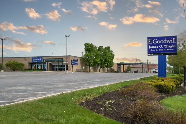

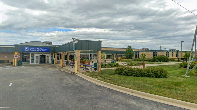
This Property Is For Sale
NEARBY LISTINGS FOR SALE OR LEASE
Property Detail
6055 N 91St St
151-9996-111-7
LANDS IN NE 1/4 SEC 29-8-21 COM SE COR SD 1/4 SEC-TH N ALG E LI SD 1/4 SEC 527.42-TH W PAR TO S LI SD 1/4 SEC 366.08-TH N PAR TO E LI SD 1/4 SEC 50.58-TH W PAR TO S LI SD 1/4 SEC 469.77-TH S PAR TO E LI SD 1/4 SEC 578 TO S LI SD 1/4 SEC-TH E ALG S LI
Miscellaneous
Milwaukee
X
Wisconsin
55089C0245G
9.94 AC
2024
Milwaukee NW
2024
Milwaukee/Madison
000502
Milwaukee-Waukesha-West Allis, WI
DEMOGRAPHICS near 6055 N 91St St
1 Mile
3 Mile
5 Mile
2024 Total Population
14,987
99,807
258,469
2029 Population
14,778
97,972
254,802
Pop Growth 2024-2029
(1.39%)
(1.84%)
(1.42%)
Average Age
33
36
38
2024 Total Households
5,243
38,163
103,780
HH Growth 2024-2029
(1.49%)
(1.84%)
(1.52%)
Median Household Inc
$46,872
$52,070
$54,476
Avg Household Size
2.80
2.50
2.40
2024 Avg HH Vehicles
1.00
1.00
1.00
Median Home Value
$140,767
$153,924
$181,834
Median Year Built
1962
1961
1957
Nearby Places
- Restaurants
- Banks
- Shops
- Fitness
- Groceries
PUBLIC TRANSPORTATION
AIRPORT
General Mitchell International
DRIVE
WALK
Distance
General Mitchell International
33 min
17.0 mi
Freight Ports
Port Milwaukee
DRIVE
WALK
Distance
Port Milwaukee
26 min
12.8 mi
Nearby Properties
Address
Land Use
TOTAL SIZE
Lot Size
Zoning
Address
Land Use
TOTAL SIZE
Lot Size
Zoning
369,652 SF
20 AC
Address
Land Use
TOTAL SIZE
Lot Size
Zoning
121,472 SF
8.97 AC
Address
Land Use
TOTAL SIZE
Lot Size
Zoning
33.49 AC
TL
Address
Land Use
TOTAL SIZE
Lot Size
Zoning
222,355 SF
4.32 AC
Address
Land Use
TOTAL SIZE
Lot Size
Zoning
8.03 AC
RM1
Address
Land Use
TOTAL SIZE
Lot Size
Zoning
197,426 SF
26.34 AC
PD
Address
Land Use
TOTAL SIZE
Lot Size
Zoning
206,529 SF
7.88 AC
PD
Address
Land Use
TOTAL SIZE
Lot Size
Zoning
245,266 SF
18.11 AC
PD
Address
Land Use
TOTAL SIZE
Lot Size
Zoning
298,666 SF
5.09 AC
PD
Address
Land Use
TOTAL SIZE
Lot Size
Zoning
209,138 SF
14.70 AC
Address
Land Use
TOTAL SIZE
Lot Size
Zoning
21.66 AC
M2
Address
Land Use
TOTAL SIZE
Lot Size
Zoning
326,619 SF
30.69 AC
PD
Address
Land Use
TOTAL SIZE
Lot Size
Zoning
160,000 SF
12.48 AC
Address
Land Use
TOTAL SIZE
Lot Size
Zoning
12.49 AC
TL
Address
Land Use
TOTAL SIZE
Lot Size
Zoning
12.48 AC
IL1
Address
Land Use
TOTAL SIZE
Lot Size
Zoning
104,365 SF
9.85 AC
PD
Address
Land Use
TOTAL SIZE
Lot Size
Zoning
378,511 SF
22.19 AC
Address
Land Use
TOTAL SIZE
Lot Size
Zoning
17.84 AC
TL
Address
Land Use
TOTAL SIZE
Lot Size
Zoning
140,757 SF
19.08 AC
PD
Address
Land Use
TOTAL SIZE
Lot Size
Zoning
221,548 SF
11.80 AC
PD
Address
Land Use
TOTAL SIZE
Lot Size
Zoning
42.07 AC
IL1
Address
Land Use
TOTAL SIZE
Lot Size
Zoning
93.72 AC
PK
Address
Land Use
TOTAL SIZE
Lot Size
Zoning
225,174 SF
6.68 AC
Address
Land Use
TOTAL SIZE
Lot Size
Zoning
136,544 SF
11.32 AC
Address
Land Use
TOTAL SIZE
Lot Size
Zoning
181,083 SF
8.50 AC
Address
Land Use
TOTAL SIZE
Lot Size
Zoning
21,516 SF
11.86 AC
IL1
Address
Land Use
TOTAL SIZE
Lot Size
Zoning
115,500 SF
13.08 AC
Address
Land Use
TOTAL SIZE
Lot Size
Zoning
7,420 SF
18.06 AC
IL1
Address
Land Use
TOTAL SIZE
Lot Size
Zoning
17.91 AC
RS5
Address
Land Use
TOTAL SIZE
Lot Size
Zoning
157,152 SF
21.09 AC
The World's #1 Commercial Real Estate Marketplace
Connect with us
© 2025 CoStar Group
The information above has been obtained from sources believed reliable. While we do not doubt its accuracy we have not verified it and make no guarantee, warranty or representation about it. It is your responsibility to independently confirm its accuracy and completeness. Any projections, opinions, assumptions, or estimates used are for example only and do not represent the current or future performance of the property. The value of this transaction to you depends on tax and other factors which should be evaluated by your tax, financial, and legal advisors. You and your advisors should conduct a careful, independent investigation of the property to determine to your satisfaction the suitability of the property for your needs.